Good Thursday, everyone. Rain is rolling back into the bluegrass state and it’s likely to become heavy over the next couple of days. Gusty winds and a crack of thunder may even join our wet weather party. Once we get through that, we have to focus on the possibility of some wintry stuff early next week.
The rain that moves in today will be a cold one with temps generally ranging from the upper 30s to the low 40s in most areas. If the drops make it in early enough, I could see how a few spots could get a touch of frozen stuff.

Current temperatures

Thermometers will rise tonight and could be near 50 by Friday morning as a warm front drifts through here. Rounds of showers and some rumbles of thunder will then sweep in during the day as gusty winds continue. Highs could push 60 in some spots.
That low will then roll right on top of us Friday night and Saturday with more in the way of heavy rain…
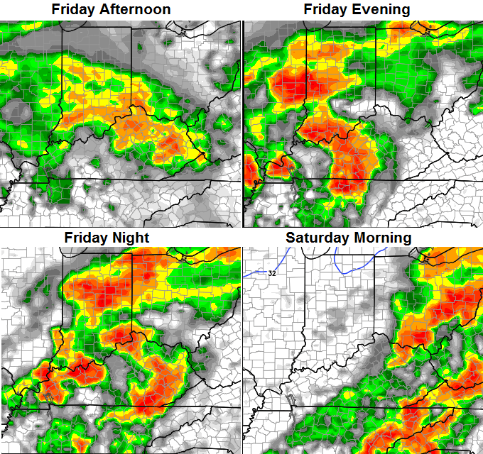
Things may try to dry out from west to east during the day Saturday as colder winds blow. Temps will start well into the 50s and then crash through the 40s…
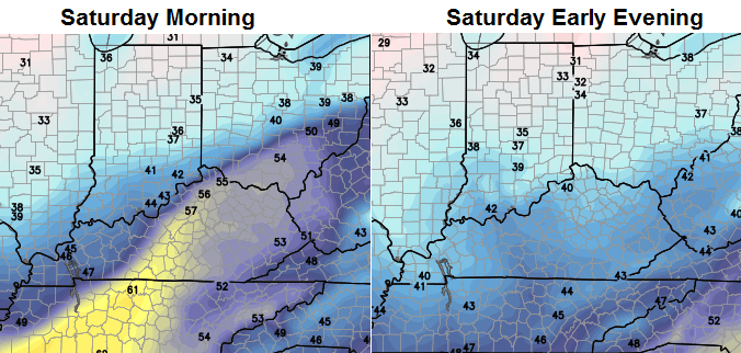 That sets the stage for chilly, but nice weather for Sunday. Highs in the 40-45 degree range will be common after lows in the upper 20s and low 30s.
That brings us to the POTENTIAL for some wintry stuff next week. The models, as expected, have been all over the place in recent days. That’s something I said would likely take place and we are seeing that now. The latest European Model for Tuesday into Wednesday…
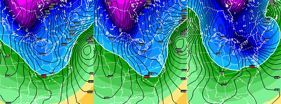
That basically brings a cold front through here with some flurries and snow showers with cold air filtering in. You can also see how it pounds New England with a huge snowstorm.
Until the models can figure where to stick the cutoff low, they will show a lot of change from one run to the next.
To get us back into a true winter pattern, we have got to turn mild for a bit. I actually think that happens very late next week into a part of the following week. Coming off a cold November, we usually have to sacrifice some days for the pattern to reload. I’ve actually talked about this happening for a while now and I’m finally seeing the setup that can provide that.
Don’t sweat it because this has happened in MANY of the great winters of years past. 1939, 1977, 1978, 1984, 1993 and 2013 come to mind for having extended mild periods in December before going boom! There is only one awful year I’m looking at that I can’t seem to write off… 1991. That year had a few similarities to this one and was a total stinker.
Our pattern should snap back into a wintry one in the week leading up to Christmas.
I will have updates later today. Take care.

In the winter of 1991-1992, it was mild to start off with until Jan15, 1992. I had my first baby on that day. We got a lot of snow that evening. Everyone had to leave the hospital right after my daughter made her arrival. The snow was coming down hard. I got to watch it from my hospital room with my newborn. 🙂
Jog my memory about the winter of 1991. Can’t recall whether that one was mild or harsh.
Big question for a lot of us is if Mother Nature breaks the 32/33 degree “law” this winter, or same old rinse and repeat. Then we watch the cams on CB’s site that show OPS. Other Place’s Snow.
No rinse and repeat here in southern KY Bubba, as usual it will be the same ole wash out and repeat… Same ole story year after year…
Since nobody is up this early to report…on NE side of Louisville, slush is starting to format on patio and sidewalks from the sleet/ice falling.
Looking at the tropics, super typhoon might affect Japanese islands. If this happens could we be looking at another cold outbreak in a couple of weeks or less? Perhaps. And an active southern stream…hmm.
Of course, first, the supertyphoon has to hit the Philippines.
Thanks Chris. Anybody know where one can gat a good deal on an ark? Looks interesting to say the least. Guess I will have to drag out the waders for the next couple of days at work. Have a great Friday Eve everyone!
remind me was 1991 not a bad winter as far as not much cold for snow?
Thanks Chris. It is miserable working outside today. It was just on the edge of ice for awhile. I’d much prefer snow. That said, I sure hope we can match up with one of the snowy years of past.
Really appreciate all the knowledge the posters have too.