Good Friday to one and all. Heavy rain is rolling across the bluegrass state today and it’s bringing milder air and gusty winds with it. The mild part of the equation won’t last long as the chilly stuff pushes back in on Saturday. What about the chances for winter weather early next week? That’s a question I don’t really have the answer to, yet.
Speaking of winter… I will show you some maps that back up the thought of true winter settling in later in the month.
The rain today will be locally heavy at times with temps surging from south to north as a warm front swings through. Highs could flirt with 60 in a few spots.

Current temperatures

Rain REALLY picks up tonight into Saturday morning as low pressure works right on top of the region. Some rumbles of thunder will also be possible. Most areas will pick up a good 1″-2″ rainfall with local amounts near 3″ possible. That could cause some rises on the smaller creeks and streams.
Gusty winds may spike to 35mph at times.
Temps on Saturday start in the mid and upper 50s and then drop like a rock from west to east. Most areas will be into the upper 30s and low 40s by early evening. There is even a small chance for a touch of frozen stuff in the far southeast as the leftover moisture exits.
Sunday looks DRY!!!! Colder air will be noted with upper 20s to start and upper 30s and low 40s to end it.
It’s at this point things try to get a little more interesting. Every model except the GFS dig a system into our region with a huge storm developing along the east coast. The European Model has much more of a phased look with a glancing blow of system snow to Kentucky…
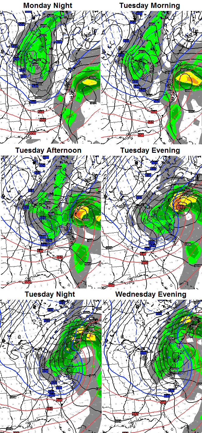
That is one heck of a slow-moving storm across the northeast that would pound those folks with snow. For us… the heaviest still stays to our northeast, but wraparound snow showers and flurries would be possible Tuesday and Wednesday. That’s also w pretty cold look for us. Of course, that’s assuming that model run is correct.
We need to get into the weekend before we get a better handle on the exact impact this system could have on our weather. If we can somehow get that system to phase a little farther west… we would be in some big business. Conversely, if it phases farther east… you get the idea.
It should also be noted that the European Model never brings a big mild up our way through the 10 day forecast period. It keeps temps normal to below normal. This matches up very well with the recent trend in the actual weather. The cold is winning the overall battle in a period that SHOULD favor warmer temperatures.
If you’re a regular reader, you know I’ve been hawking a first half of December pause in the real winter action. The extreme November pattern had to break and it’s likely reloading to make another run at us later this month and into January.
The hot off the presses loooong range maps from the European Model shows the return of winter very well. It wants to get the party started with a slow moving closed low the week before Christmas…

Now, watch the evolution of the pattern from Christmas week into early January. Notice how blocking makes a VERY strong return across Alaska toward the Arctic and how deep troughs then dig into our region…


 I doubt too many folks around here would be complaining with a pattern like that! Wait… I forgot who I was talking to. 🙂
I will have updates later today. Take care.

Chris, When do we see 70’s and 80’s again? I’ve already had enough winter!
all tho u didnt say direct, i sorta got the feeling you may be leaning towards the european model. giving kentuckys trend with winter storms, the big one wil miss us just to our northeast.
the pattern will make a lot happy = warm winter and you forgot you was talking to “winter and snow” lovers here on the blog?
not trying to start trouble chris. got to much respect for your blog and our members here. just what i got out of this blog. the pattern for late dec into jan could be just as easy be saying cold and snow lovers are gonna love it , and u forgot how how much we like it.
whichever way the weather goes, its gonna go, but as far as having someone to keep a eye on patterns and whats coming for my area, i will put my money on you and come out a winner almost every time.
wanna thank you for all you do for the blog. i dont have cable or satalite right now to watch you on tv, so i follow you on the blog. i also will check in with nws jackson office web page. i am thankful for all the tv guys and weather office’s to keep the public informed of upcoming weather events, be it good or bad.
32/33: It’s the Law!
If I recall correctly, I think a blog comment someone made about the 76/77 winter was that it didn’t start getting really bad until just after New Year’s Day. So basically, Dec ’76 wasn’t snowy (from what I gathered reading the comment)
MarkLex you are correct…I was nine at the time and remember going back to school the week after New Years then all hell broke lose with snows of 1 – 3 inches cold cold weather then another 3-6 with colder weather then the only blizzard Louisville has ever recorded with 15 inches of snow and temps plunging to below zero for several days. We where out of school for two or three weeks. Temps well below freezing for more than 20 days straight. All after a December that was dry and mild to say the least. Walking on a frozen Ohio River is a memory I will never forget. Hope 2015 brings the same.
I didn’t get on the ice but watched folks walk on the Ohio River. I don’t want that cold weather this year. A mild winter would be welcomed.
Bite your tounge feederband…..LOL
I’m with you, I don’t want that kind of cold either. Last winter was bad enough with frozen and busted pipes. Did what I could to add insulation but you can only do so much with a 100+ yr. old house. Don’t get me wrong, I want snow. But we don’t need ridiculously brutal temps to get it.
I wasn’t 9 but I remember it well, too. You are correct on the timing. We had a relatively mild period and just after the New Year. We had snow on the ground for the next month! Just as soon as the roads would get clear, it would come again. Would love to see a big snow like that again! (Maybe not for a month)
77 was the winter the Ohio river was frozen over. I went to the Bengals Chargers playoff game and thought I was going to freeze to death. It started snowing sometime in November and didn’t stop until March. New Circle Road was one lane because there was no where else to put the snow. Public schools were out for a long time, so long they went on Saturday to make up days. I’m not sure what year it was, but the Bengals made it to the Super Bowl, and lost he he, but the actual temp that day was 27 below with wind chills in the 40 below range.
That was 1981-82.
Hopefully a white Christmas? My son is going to protest if we don’t have snow on Christmas. He said we had snow on Halloween and snow on Thanksgiving. If we don’t get it for Christmas, he’s going to “show mother nature a thing or two” and protest by burning a tree. (Mind you, the tree is already half dead…) He’s such a rebel.
I remember well the winter of 76/77 I was a freshman in highschool in rural Rockcastle Co just after Christmas break the weather turned brutal snow every week for it seemed like a month I can still remember Brad James on WKYT saying here we go again as another snow system moved into KY. Then it turned cold I mean bitter cold with temps 0 or below for weeks. I can still feel the cold on my skin as me and my Papaw went out and fed the cattle every evening we had a few covey of Quail on our place Papaw would take cornbread and clean places off the ground to feed them. I want snow but that I do not want. In all school did not go back into session til around mid March. Happy snowy winter to all and thanks Chris for all you do.
We didn’t have the snow removal equipment then that we do now. Snow and brutal cold came in and didn’t leave. No melting. We were stuck with it until March.
BRING ON THE COLD AND LOTS OF SNOW!!!!!!!!!!!!!!!!!!!!
Man, I sure do agree. The colder the better. We never even get close to brutal cold around here, so bring on the cold and snow.
I gave up on predicting snow or dwelling. If it were not for CB’s blog and the bonus of Rolo-coaster posts for entertainment, I would probably just say meh and move along.
But BubbaG if you did that, we’d miss your great one-liners…..
Thanks Chris and posters.
I really enjoy the snow talk and looking back at the big years like 76/77. I remember some of that stuff – big old snows with our street getting thick with snow and ice build up and missing a bunch of school. Seems like it was back to back years that we missed a bunch. One year was really snowy and one year was super cold.
Thanks Chris. We actually have a break form the rain at the moment and I am taking advantage of it! Going to get interesting it looks like.
Have a great Friday everyone!
The blizzard of 1977 was brutal. I was working in downtown Louisville and couldn’t get to work for at least 3 days. Interstate 65 south was closed. Unless u were an emergency vehicle u were bared from traveling on any major highway. Few winter storms have impacted the Ohio valley like the blizzard of 1977.