Good Saturday to one and all. Colder air has arrived right on cue and it’s pushing the heavy rain to our east. Now we turn our attention toward a system rolling on Monday night into Tuesday. That one is likely to bring some light snow to parts of our region.
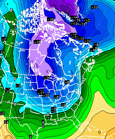
The disturbance that dives in here from the northwest continues to look rather potent…

That creates some fast rising air which would lead to some light snow across central and eastern Kentucky by Tuesday morning. That will also coincide with the coldest 850mb temps pushing in…

That will give the atmosphere another little kick in the pants and allow for snow showers and flurries to develop on a northwesterly wind flow.
You guys have seen me tweet several times about not underestimating a northwesterly wind flow… that’s the case again Tuesday into Wednesday. That’s especially true when combined with low 850mb temps. Well, the European Model shows a second 850mb thermal min passing across eastern Kentucky late Wednesday…

That could keep snow showers and flurries holding tough during that time.
Highs Tuesday and Wednesday will run in the 30s with lows deep into the 20s. Temps by Thursday head toward 40 then into the 40s by Friday. So much for another warm week. That will make 3 weeks in a row certain weather circles have told you a blowtorch was coming… yet it never showed up.
Things will break milder next weekend into early the following week, but that happens as a true winter pattern begins taking shape. The change begins later in the week then kicks into high gear for Christmas week. Even the GFS is picking up on it. Check out the cold that kicks off the week…
 The final two weeks of the month look much colder with the active storm track continuing. That’s a pattern you have to like.
Tommy Boy is good with it!
Enjoy the day and take care.

Some snow for Christmas would be great, thanks for keeping us updated!
The most important question ever asked on the blog: “Who is Tommy?” (I’ve got to get out more!)
Love your site Chris. Amazing how many times I have seen forecasts for warm while you called for colder and you win. Just saw a forecast where they were talking above normal until Dec. 20 with 80% confidence. And something about it looking like it will be warmer for most of the country through the end of Dec. Hope the cold can keep winning out for Christmas and people get that snow on the ground.
The title of John Belski’s last two posts on his blog are…
“Mas-sive nationwide warm up is on the way”
And his latest…
“The warm up looks to be delayed”
From one day to the next. Not bashing or trying to say he’s a bad met, just stating a perfect example of what CB has been saying.
I have it on good authority that the warm-up will be here in 5 months…
I think we all do… lol!
I think that good authority might just be right. As for Belski’s last 2 post it seems that is a trend. One of the places I read calling for a warm-up had a similar thing for Thanksgiving. Not to mention the forecast they have always seems to show the warm-ups and then they modify those temps down as it gets closer.
One of the big things I like about Chris is that he does not generally take one model to rule them all. And if the models see something he does not agree with based on other factors he will tell it on his blog. Showing the models and saying he is not buying it yet.
John Belski could say it will be 80 tomorrow and he’ll still have my respect. He’s a met icon, some consider Belski a met legend in the Louisville area very very well respected.
Rolo likey toooo!!!! yea see chance at a serious white Christmas as well!!!! be nothing like 4 plus inches on the holidays!!!!!!!!!!!!!!!!!tx Bailey!!!!!!!!!!!!!!
Warm up was suppose to happen this week into next. Most all Mets had stated that before Turkey day. CB had the cold driving in Around Dec 12/13th. Now the warmth is now being forecast for that weekend. We have to have a warm up in order to get the atmosphere juiced and a true flip to winter. I also believe the chances are going to be higher than normal for a white Xmas and a very cold January.