Good evening, gang. It’s game on for some snow showers and flurries to fly across the region over the next few days. The cold front responsible for the flake action will cross the state late tonight into Tuesday morning with a mix of rain and snow showers and falling temps.
The prime time for flakes will be from Tuesday afternoon into Wednesday on a northwesterly wind flow.
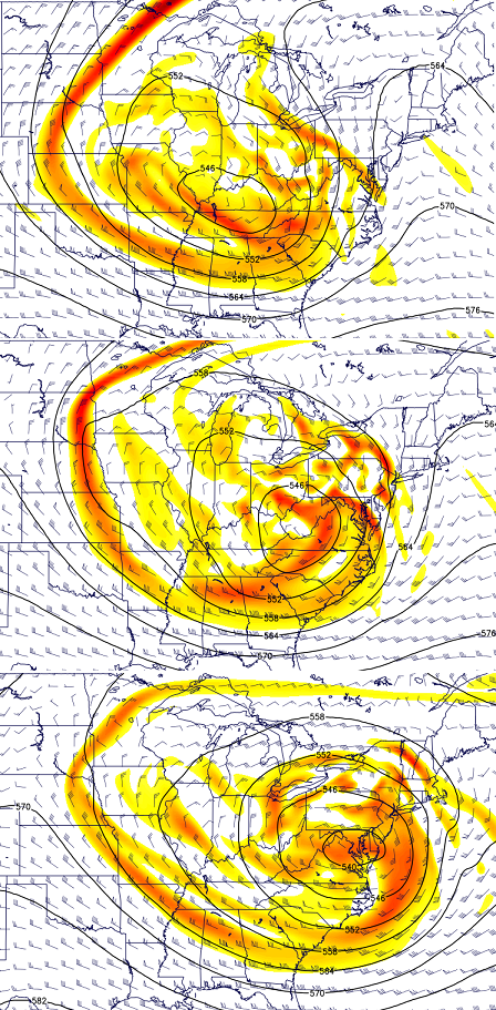
A big upper level low will continue to pinwheel across the east late this week into the weekend. That will keep our temps at or below normal. Here’s the temperature departure map for Friday…

Saturday finds the core of the mild passing us by to the north and west with some lingering chill in the east…
Temps will moderate this weekend into Monday, but the extent of that remains to be seen. This is the small window of opportunity for mild I’ve been pointing toward.
It won’t last long as another big closed upper level low develops early next week. The progression of this will be fun to watch because you can get some wild model swings. The new Canadian Model brings that system right on top of us from late Monday through Wednesday…
That would have a wintry component if it works out like that. Something to watch as we roll forward.
I continue to track the Christmas week potential as we are likely to see a very wintry pattern taking shape. A big ridge goes up out west and floods the east with cold air from Canada. Throw in a active southern jet stream and some fun can be had for all…
 I think that week is the beginning of what may turn very harsh as we head into January. I’m seeing some big signals showing up in the longer range!
Enjoy the evening and take care.

Thanks CB! The only thing I can not shake is the term, “Wintry” to me is synonymous with light to mixed precipitation for us south of 64 folks.
You are on the right path there. If he means just snow, he’ll state that exactly. “Wintry” seems to creep in when it looks like a barely accumulating snow or anything frozen mixed with rain.
I may go have a bad dream about 35 degree rain on Christmas now, heh.
Lol… nah… this is a snowy pattern coming up. I wouldn’t be surprised to see a total smackdown storm at some point.
Im holding out for that rare double number snowfall, lets see if the streak can be broken this year??
Thanks Chris. Maybe one of those analog years of 1977 will show up again! Guesses will wIt and see.
Meant like 1977. The previous one was a humdinger too for southern Ky.
Thank you, Chris.
Looks like Old Man Winter is fixing to set the table for some fun!
I see the warmup bringingvrain with few flurries on backside as cold air comes in. Thats my take on it.. its a week away.
Christmas week into jan could show some snow and more of winter type weather. Hope we dont get a cold 21 degree freezing rain like few years ago. Even with temps in 20s southeast ky couldnt escape rain.
I will say this the start of December when it comes to snowfall nationwide is pathetic. Slowest start in decades this time last year almost 59% of the US had snow on the ground and this year only 18% which is one of the slowest starts in the snow category in decades.
At least Typhoon Hagupit weakened before hitting the Philippines a few days ago. The effects, although still with some destruction and loss of life, are only a small fraction of the enormous tragedy that Typhoon Haiyan unleashed last year.
Interestingly, Hagupit is forecast to continue westbound as it weakens even more. This is unlike other Pacific tropical systems that curve to the northeast, become extra-tropical and then often effect wx here in North America. Curious on any thoughts on how Hagupit’s lack of a turn back to Alaska may effect us one way or the other.
I dont mean to be so negative with my posts chris. I think i just get littlr frustrated with how lack of much snowfall has happened in our area last 2 or 3 years. They been couple 2 or 3 inchers. But didnt last long . I remember one last winter thst gave few inches, then it quit snowing and warmed up to 46 degrees, melting what snow we did get. Guees what? Next day it was cold again .
I hope we get to see the streak broke this year. Would like see that rare double digit here ol clay. Been long time since its did that.1996. Before that, 94 and 93. The 98 dusting gave us about 7 to 8 inches of the heavy stuff.
Hope the week after Christmas is cold and snowy – I am planning a backpacking trip in eastern KY and want a challenge – but not the 35 degree rain type. I have done that too many times…
I just want a snowy Christmas like we had when I was a kid. That was a long time ago. I love the snow.