Good Tuesday, folks. Much colder air continues to push into the region today and it’s bringing some snow showers and flurries with it. This action won’t amount to much, but will add to our Christmas spirit. It’s also a sign of the winter season that’s just beginning.
I guess this winter actually got started much earlier than normal. We had snow on Halloween then frequent snows throughout November. The cold from the month was unreal and the final numbers are in. This was the 4th coldest November on record for Kentucky. We certainly weren’t alone in the cold…
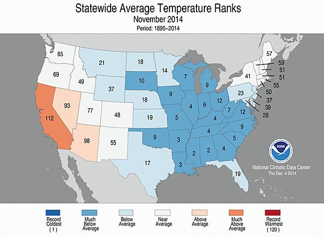
Can you imagine what would happen if we can replicate those kinds of departures in January? Hmm
Ok… back to where we are in the precious present. Rain and snow showers will be around early today with some flurries and snow showers taking over this afternoon and evening. I don’t see much in the way of sticking snow unless you are in the mountains of southeastern Kentucky.
Temps today will hug the upper 30s for much of the day.

Current temperatures

The snow showers and flurries will hang tough into Wednesday. This is one of those setups to where you can’t look at the traditional levels of the atmosphere to judge the flake potential. Northwesterly winds and low level moisture will often result flakes flying around. Check out all the low level moisture that shows up at the 925mb (approx 2,500 feet above ground) level…
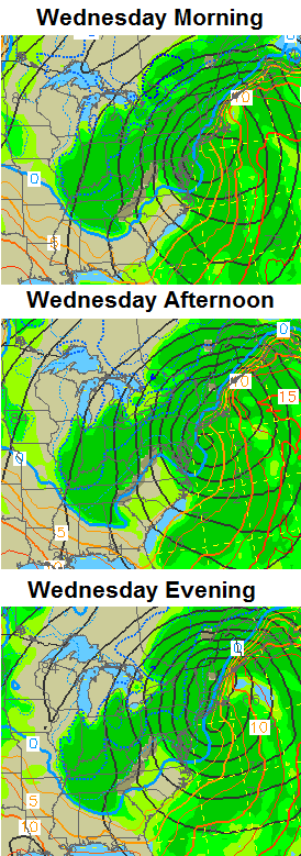 That’s not a level many people will look at, but they should on a northwesterly wind. 🙂
Again, in the overall scheme of things, this isn’t a very big deal in terms of snow.
With the big cutoff low spinning to our northeast through the end of the week, temperatures around here will be held to normal or below normal readings. The “new” GFS is back up and running and shows a similar temp trend to what the European Model has been suggesting. Check out the highs…
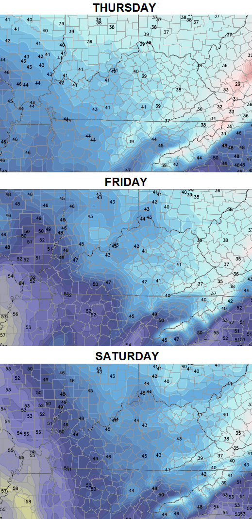
Gusty winds will make it feel colder than what your thermometer shows over the next several days. Wind chills by Thursday and Friday mornings could even reach the teens.
Things do improve over the weekend and I think most areas hit the 50s on Sunday. That may last into Monday before another system rolls our way for the Tuesday through Thursday period. That will knock our temps way down and could deliver some wintry weather as another upper level low spins up. This one may push right across our region…
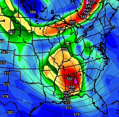
The pattern continues to progress toward one that can throw a lot of fun and games our way Christmas week and beyond. To be honest… it’s a loaded setup with ample cold air available to meet up with a super active southern storm track.
I will have updates later today. Take care.

Not excited about this pattern at all. In fact, one of the gloomiest and ugliest periods of gray, cold and rainy weather I can remember of here in KY, and that’s saying a lot. As I type this, the advertised light snow and flurries that are supposed to be the precip type? Any guess what it’s doing here in Laurel co? RAIN.
Per the usual, it’s always next week and the week after.
Bryant–I’m with you!!!
Bubba–I’m with you!!! Already looking at this quote too many times “and could deliver some WINTRYweather” . The weather here in CKY (not northern KY)…Has been grey / glooming / raining. Temps may have been colder than normal, but it didnt bring us much snow. The snow for halloween and thanksgiving was a skiff of snow here in Richmond
So I guess I shouldnt be that upset for KY..the term WINTRY WEATHER for CKY does mean a cold rain!!!!!
Looking at “next week” upper level low right on top of us means 35-40 degree rain. And most likely the ohio river counties get some snow. Oh yeah, we probably will get a wrap around inch of snow.
Sorry to be grumpy, I guess I dont have faith in snowy weather, just like I dont have faith in my bengals pulling it out the next three weeks!
“33/32” and “wintry” are the same thing and probably a common theme south of I64, or in higher elevations this winter. Word.
lower elevations…. You see, the point is areas south of 64 can get some good snow if HIGHER up…. You see?. Oh never mind 🙁 😉 🙂
Thanks, Chris. I like our chances for some decent snows down the pike.
It’s certainly colder now than when when I stopped by the office this AM.
Thanks Chris for all you do. It is cold today. I would be very happy to see a few flakes. Everyone have a great day and stay warm!!!!!!!
The ‘next week’ phenomenon reminds me of the Colbert Foundation motto, “Making a better tomorrow…tomorrow”.
The description of November snow, who exactly got all of this snow in November in KY? If you are one of the 1% in the description, sound off so we know where to build in-state winter homes.
In all seriousness though, it would be handy to have an accurate county-by-county snow fall map, so we can see clearly the results of last month.
Beautiful video guys walking on crystal clear ice in Slovakia.
http://youtu.be/8WBqX7MSqWw
There are times I simply have no idea what you’re talking about. This would be one of them.
I second that thought CB.
At least he is more fun than Rolo. 😉
I do not like Colbert, but luv the Rolo-coaster casts 🙂 Might not get much snow, but that is entertainment 🙂
I think it is the back yard perspective 😉
I feel update coming in 44 min!!!!! time we get back to song of the day!!! so ALMOST HOME by Craig Morgan is today..