Good Tuesday afternoon, gang. This month has been consistent with two weather things… lack of sunshine and temps that skew colder in a pattern that suggests otherwise. Both trends look to continue over the next week as we lay the groundwork for a lot of winter potential later this month into January.
Rain showers and some snow showers continue to dot our skies this afternoon with temps slowly dropping into the mid and upper 30s. The snow showers and flurries will then take over across the central and east later today into Wednesday. Again, the flake action is not a big deal.
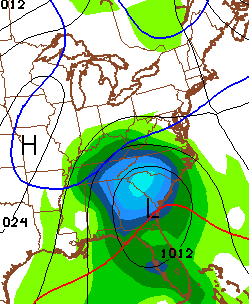
The big cutoff low across the northeast continues to show up slower on the American Models. Check out the NAM…

That’s a flow that should keep many temps in the 30s for Thursday with low 40s on Friday. It’s also one that will produce some… wait for it… wait for it… clouds. There is some indications of some clouds and sprinkles trying to develop over the weekend. That’s when temps begin to moderate, but the latest model runs are tempering the temperatures. The raw numbers from the GFS now have the highest temperature for Lexington at only 50 degrees and that comes Sunday.
As I mentioned a few days ago… the window for any mild up is closing fast and it’s looking more and more like we will never see a true mild spell this month. How’s that for a blowtorch for weeks on end? 😉
However mild temps get late this weekend into Monday, it all gets smacked down quickly with a system that rolls in from late Monday through Wednesday. That may very well have a wintry aspect to it as temps come way, way down.
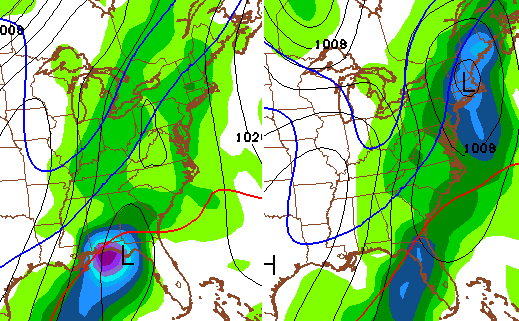
We’re also seeing the models now going toward the cold and active pattern for Christmas week. Even the GFS is picking up on the potential. Here it is for the weekend before Christmas…
And for Christmas Eve and Day…
I don’t look for details from two weeks out, but I do look at the overall pattern coming from the models to see if they match what I think will happen. It’s a pattern that should feature cold air coming in from the north with a southern storm track that continues on the active side. Once it sets up… it’s likely to stick around for a while.
I will have another update later today. Take care.

Thanks Chris. I personally would love a blowtorch since we aren’t getting any snow. Gray skies and rain is taking it’s toll on my mood. Christmas time shouldn’t be depressing!
Kind of like it myself. Cozy weather 🙂
I like too Bubba G
Bad case of pneumonia, gray, rainy cold weather.
No thanks, I’ll take a blowtorch pattern. Personally to say this a true winter pattern and that we are sticking it to the models advertising warmth is grasping for straws. At this point, one way or another is suitable. Either sun and above av temps or a true winter pattern with realistic shots at snowfall.
I like the cold dreary weather. Not that I don’t like the sun. But there is no fun in the sun when it is to cold out to enjoy it. Like our chances for wintery weather over the next several weeks. Thanks CB for the update.
Just changed my phrase…
Gray – it’s the new blue (where skies are concerned)…
Ready for some sunshine, personally, no matter how cold.
But thanks for the great job, Chris!
Hoping for a white Christmas this year. There is a possibility this may happen! That would be great! Thanks for all u do Chris.