Good Wednesday, folks. Cloudy, cold and flakey weather will be noted across the bluegrass state today and it looks like the cold may be hard to get rid of. The clouds kind of goes without saying since we’ve barely had any sun at all this month. I’ve mentioned many times our temps are skewed colder than the pattern would suggest and that it’s probably a good signal for much colder times ahead. I’m pretty convinced of that at this point.
The colder times to come should also be accompanied by a SUPER active southern branch of the jet stream. This pattern is loaded for bear later this month into January. More on all that in a bit. Let’s get into what happens in the shorter range.
High temps today will basically hold in the 30s across the entire region with more in the way of low clouds and snowflakes. Out and out snow showers will be possible across the east and southeast with the chance to whiten the highest hilltops.
The huge upper level low across the northeast will sit and spin… and spin and spin. It doesn’t want to move very much in the coming days…
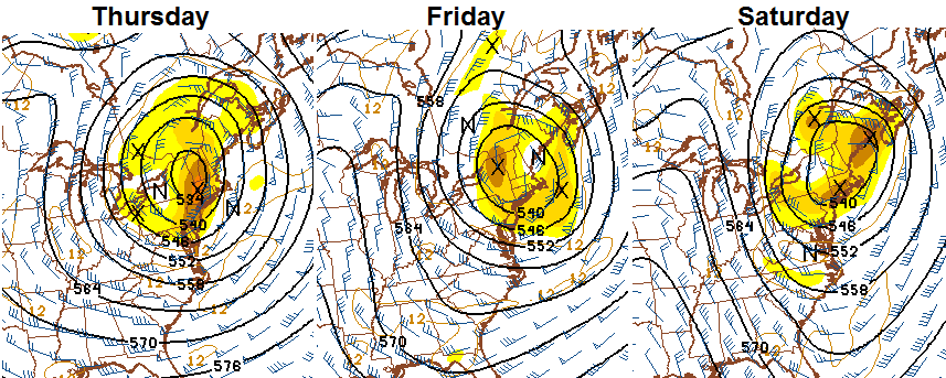
That is really something to see and shows just how crazy the atmosphere is right now. What does it mean for our actual weather? It keeps us in a cold northwesterly wind flow through the start of the weekend. That means clouds will be tough to break, but a few rays of sun MIGHT be possible late Thursday or Friday. Temps on the NAM stay in the 30s for highs in central and eastern Kentucky through Friday. I think it’s safe to call for upper 30s and low 40s both days. Lows each morning will be in the 20s. Gusty winds make it feel even colder.
That brings us to the weekend and my worries over our wimpy window for a mild up are very real. With the upper low still going to our northeast and the milder air in the plains… watch for some clouds to try to develop around here. There is even the chance for some sprinkles. Temps will moderate some, but I can’t call upper 40s and low 50s “mild”. We get those numbers at some point every December around here.
That said… the Hi Res GFS keeps the east much colder than the west with weekend highs…
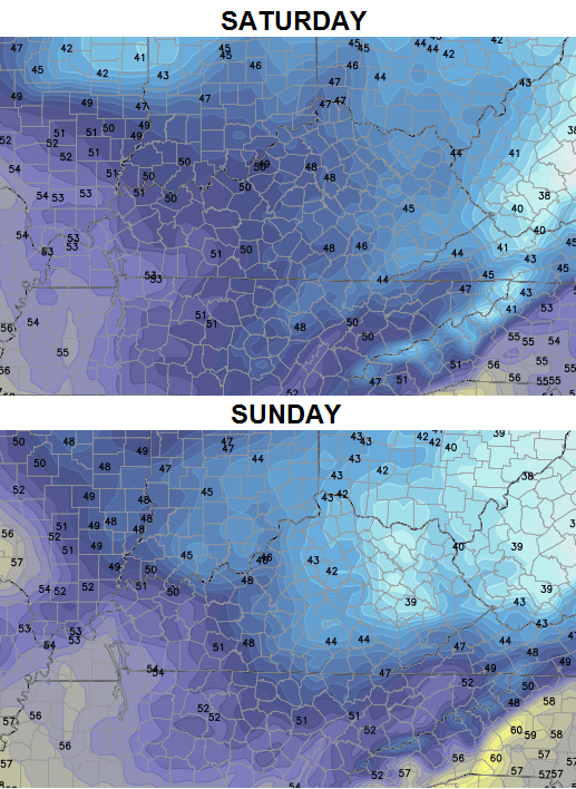 The Sunday highs look rather funky and likely too cold in the central and east. Maybe the model is trying to tell us some low clouds and fog hang around all day? We will have to see about that.
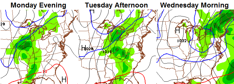
Things will begin to change in a hurry by later Monday as another slow-moving system rolls in from the west. This is being pushed by another bowling ball upper level disturbance that the models are struggling to figure out. The European Model brings this bad boy right on top of us. Check out the progression from Sunday through Tuesday…

The GFS is all over the place with this. The latest run has rain rolling in with some snow showers and very cold air sweeping quickly in later Tuesday and Wednesday…
Don’t worry, the scenario with that will change a lot in the coming days. But, I am seeing a decent chance of wintry weather to be followed by a nice shot of cold from that system.
I keep harping on the setup that develops Christmas week and beyond and for good reason. I posted this map with an earlier update, but it’s worth showing again…

Late month into January could be very fun for much of the country.
I will have updates later today… make it a good one and take care.

100% drizzle yesterday and looking at overnight temps, that didn’t change for overnight. Would be happy to see even just a single snow flake today. Our local Snow Dome can bugger off.
Beautiful pic from Vancouver Island, Canada
http://i.imgur.com/s4Y6TDh.jpg
At least CB put “Winter Pattern” instead of “Wintry Pattern”. 🙂 😉
Agree LD. I have yet to enjoy the festive flakes .
Nothing but drizzle here in Carrie of knott co. Temps never went much below 40 overnight
Chris: Love the word “snizzle” (not the event – had enough). In Michigan during the ’60’s – ’70’s, we had Sonny Eliot and we had “snain”, plus a combo of other names for multiple weather events. So you brought back some memories for me – Thanks! Enjoy your weather reports.
Thanks Chris. I’m fired up for the active patterns coming our way.
cloudy with drizzle here in Hazard
It is another beautiful winter day. A little snow would be nice, but drizzle and low clouds will have to do.
Kept waiting for the festive flakes to arrive and for the temps to drop but we kept steady at 39-41 all day yesterday with a few heavy rain showers.
No festive flakes here either, only the usual…nasty, cold, miserable drizzle. Maybe someday we’ll a;; learn to appreciate the drizzle!!!