Good Thursday, everyone. Your friendly weather dude is getting the bug that’s going around, so I am going to try to keep it short and sweet with this post. Of course, we know my track record on trying to do that. 🙂
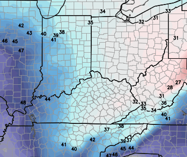
Everyone is searching for the sunshine and for good reason. We have been about as cloudy as you can possibly get this month, so a little sun would go a long way for many of us. The overcast today is going to be tough to break, but some rays of sun will be possible with highs in the upper 30s to low 40s.
Friday might have a better shot at giving us some sun with temps from 40-45 in the central and east with upper 40s in the west. The day will start in the 20s across the entire region.
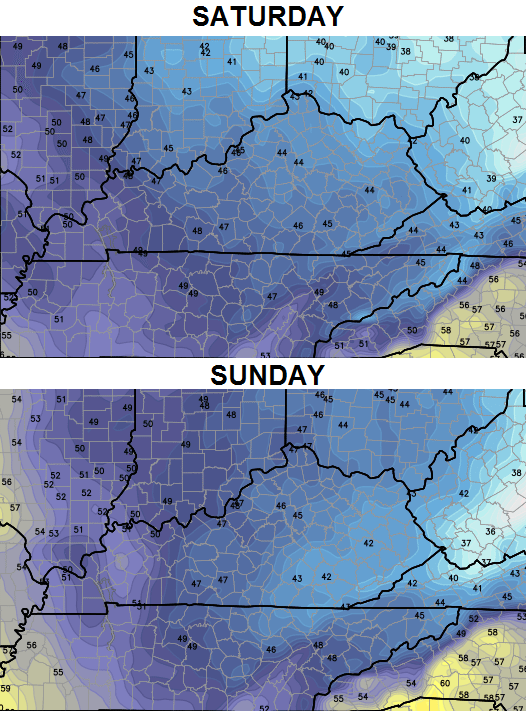
The weekend will likely see us fire up a few more clouds with the possibility of some sprinkles. Temps are still a bit of an enigma. The NAM is either pulling off a serious win or lost in the woods with the high temp forecast on Saturday…
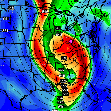
That may be on the extreme end, but it’s not like the other models are scorching the earth with the weekend temps. The European Model is now picking up on the colder trend. Check out the forecast highs from a usually warm running model…
Temps on Monday should spike as clouds quickly thicken up. Rain moves in from west to east during the afternoon and evening and that takes us into Tuesday. Colder air comes in behind that with the possibility of some flakes behind this departing system.
The active southern branch of the jet stream will then throw another storm system our way by the end of the week or into the weekend. There is a TON of energy coming from the southwest and that causes problems for the computer models.
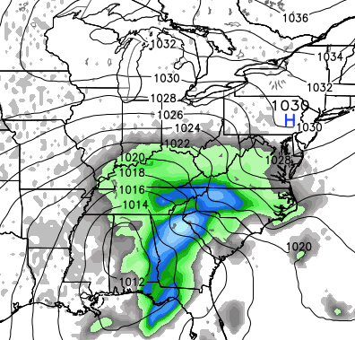
The Canadian Model continues to show this storm passing to our south…
That matches up pretty well with the control run of the GFS Ensembles…
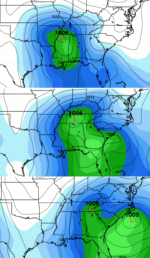
The new European also has the storm but is super wound up with it across our region…
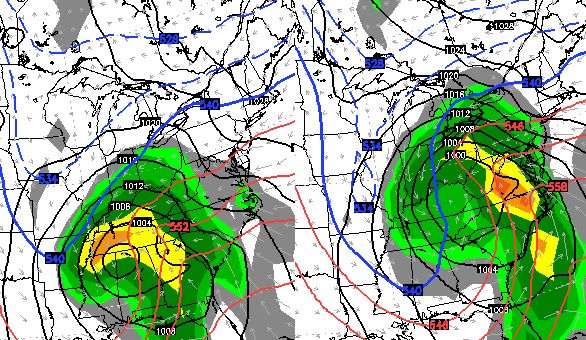
Put all of this together and you get a pretty good signal for a healthy storm system next weekend. That sets the ball rolling into Christmas week and the beginning of what could become a harsh period of winter as we close out the month and move into January.
Looks like my history of not keeping it short and sweet proved to be correct. I fought off the affects of Nyquil to stay up and get all the latest data into this update. The things I do for you people. 🙂
Make it a great day and take care.

Hope that happens, southeast ky has missed out on all the snow over the last couple of years
Nashville is also long overdue for a good snow.
Yet strange how even some areas to the south and west of Nashville and southern KY have had some decent snows. Last winter, my parents in Chattanooga/Cleveland TN woke up to five or so inches one morning. Little Rock of all places had a foot of snow Christmas Day 2013. Can’t forget how part of the Tennessee-Alabama line near Huntsville got about 16 inches in early Jan 2011.
And we people very much appreciate what you do for us!
Hope you feel better soon CB!
Thank you for all you do!
🙂
Low is riding to far north given the NW shift. It looks real good now on all the models. Once it moves in and strengthens, as the Euro is predicting, it will put KY in the cold rain spectrum or dare I say freezing rain. Chris thanks for the update and hope the bug does not overcome you to severely.
We appreciate you staying up and giving us the latest model trends CB! They definitely are giving us snow lovers some hope for Christmas week. Looking forward to tracking the southern storm stream these next few weeks!
A nice overcast this morning, such a pretty texture to the bottom layer of the clouds. Yea, sunshine is way overrated 😉 .
Seriously, nice to know there will finally be at least a little sun and blue skies, at least for a while. Thanks CB for keeping us so informed. Nashville has some nice tv mets, but you are on par with any of them!
Thanks for all you do! Hope you fell better soon! I am ready for SNOW but just not to bad on the 20th. Lol. We are driving from the Ashland area down to a Christmas show at Renfro Valley which is abt at 2 1/2 hr drive!
im not liking all these rainmakers with backside flurries….could be a cold rain winter
Chris – sorry to hear that you’re coming down with the bug. That means you and apparently half of my hometown are feeling poorly. My school district is contemplating canceling school tomorrow and here’s the kick. When I’m thinking about the possible cancellation and where I could get more info, I actually think “I should check Chris Bailey’s blog, that will help”. Duh! I’m so conditioned to anticipate snow days here that now my brain thinks I can get all my school info from the blog!
Thanks for all your hard work Chris! I have followed this blog for years. I would say it’s the best weather breakdown in the nation! I appreciate the extra effort. You the man!
Get better soon Chris!
Great outlay of models for us to ponder-think SNOW y’all!
Looking forward to the fun and games starting. Thank you Chris for all you do for us and you are in my prayers for a speedy recovery my friend…
Looking too close for a Laurel County snow, but maybe the backside will be an overachieving upslope event. Either way, a white Christmas is poetic and lovely to think about. Praying for you, Chris. Feel better soon.
I recall this time last year CB was warning of potential mega-cold coming our way in January and of course we got it. Not seeing similar wording, so does that mean perhaps this winter not expecting the same super duper sustained cold spikes?
Might be good for snow lovers, since I think those spikes actually stunted snow chances south of I64.
I hope Chris’s is on to something the national people are missing. They have been saying the snow/cold are gone till after the first of the year. I just wonder what happened with the impressive snow pack in Siberia and Canada? It was supposed to lead to a really snowy/cold Winter. With the exception of the super cold snap in November, this season is off to a pathetic start. No snowstorms in the Rockies or Midwest no lake effect except for the Buffalo Blizzard. I really hope things change.
Talk about the christmas snow showing up on the gfs!!!!
Storm next weekend doesn’t make me happy for my Christmas party. Festive Flurries would be ok though.
Go home & get some sleep Chris. Weather’s boring right now (in the immediate term) anyway.
Thank u for all u do chris. Hope u feel better.
Feel better Chris! Even though I live in SW Indiana, you’re my weather guy! Your blog brings a smile everyday.