Good sunny afternoon, everyone. That is the sun, isn’t it? It’s been so long since I’ve seen it, I barely recognize it. 🙂 I have a few minutes to drop by for a quick update on the weekend temps.
The numbers continue to come in colder for Saturday and Sunday with the NAM leading the charge. The Hi Res run for Saturday highs…

The regular run for the weekend…
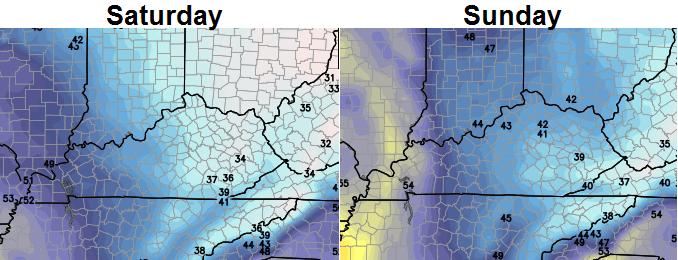 Those continue to run on the cold side of the models, but most of the latest models are coming in with colder numbers. They are also coming in with a lot of clouds and even the chance for a light shower.
The rest of the forecast into next week looks to be in good shape with clouds increasing and rain arriving later Monday into Tuesday. Temps drop behind that system with the end of the week/weekend storm signal still showing up strongly on the models.
With so much energy… and there is a TON… the models will show a lot of different solutions from run to run. This is a pattern that is going to throw a storm our way every 2-4 days. With an increasing amount of cold air… watch out. The pattern setting up from Christmas week into January is a snow setup for the Ohio Valley! It’s also one that should eventually allow for some serious cold shots!
I will update all this later today. Take care.

Thanks, CB, for the update. I’ll be in Seattle to kick off the New Year so I really hope the big snows can hold off ’til after I get back on 1/5. But chances are…I’ll probably miss out on some fun while I’m gone. :/ At least the pattern looks good for not only the first week of January…but all of January. 😀
hey Chris I’m just asking is Richmond Kentucky included in the Ohio Valley setup for snow?
Went across Black Mountain today…temperature was 24 degrees with snow on the ground.
CUTBANK MONTANA today song by Hank Jr
Chris I hope you’re feeling better! Watch that NyQuil….reminds me of Chris Farley on Saturday Night Live…he called it hibernol and he slept through the winter. We can’t have that. Anyway, thanks for all you do to keep us up to date.
Thanks Chris. Hope you are feeling better.
Apps just got in from a hard day.Looked at today’s modeling.Apps very happy starting the 20th,,Euro gone wild.Big bowling ball to south.Sure you will here more on this if it keeps on showing up..cold is coming with southern stream on steroids..