Good Friday afternoon, folks. Our weather pattern is about to kick things into overdrive over the next few weeks as a harsh winter pattern begins across much of the country. I promised you guys a big update today and me and my Dayquil are trying to deliver! 🙂
Let’s talk a little bit about the weekend. Clouds increase later tonight and Saturday and it continues to look like those clouds will throw some light showers or sprinkles our way. The best chance comes Saturday night and Sunday. High temps this weekend stay in the normal 40s.
A storm system roll into town with rain from west to east on Monday. That system then rolls through here Tuesday with much colder air coming in behind it. The European Model shows the cold look…
 That’s some pretty cold stuff for the middle and end of next week. Can we get some flakes out of that cold? It’s possible to get some behind the departing low Tuesday night and we will have to watch for some overrunning moisture streaming our way by Thursday…

I continue to see a strong signal for a bigger storm by the end of next week into the following weekend. The control run of the GFS Ensembles shows the low well…

That’s a pretty strong track for a lot of winter weather around here and across the Ohio Valley. Btw… the colors are pressure anomalies and not temperatures.
The GFS takes this on a similar path…

The European Model is the strongest and most wrapped up with this storm. Here’s Friday evening…

Saturday Morning

You can see where the freezing line is on the right of those maps. That’s not a good look… but it’s a week away and kinda silly to be worrying about temps when the storm track changes with each run of each model.
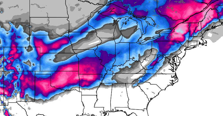
The European Model does show a lot of winter weather impacting much of the country…
Again, that’s a week away folks! Don’t get too caught up in it all because I am just trying to show you there is a potential storm system for us to track. If it can bring some wintry weather our way… it’s a bonus because I’ve been more caught up in the change to winter coming during Christmas week and beyond.
Speaking of Christmas week… the timing of these storms could mean another one arrives by Christmas Eve or Day as winter locks in.
Enjoy the rest of your day and take care.

Chris that sure don’t look like much snow for eastern ky I just don’t want rain maybe it will be cold for christmas
On the European Model snow forecast. What is the light blue, 3 or 4 inches??? That’s what is showing for the Louisville area.
More like 1-2 or 2-3 the greys are 0-.5 and .5-1 sorry if I M wrong but that is what I think.
With a NW jaunt this becomes a lake cutter. Hope I am incorrect. Will this be the year the trend is broken and we get an old skool snow storm. As CB has been saying. Things about to get wintery around here.
looks like more cold rain with backside flurries til maybe xmas week, If were lucky
Great modeling to ponder.
thanks Chris!
Just as long as ICE is not in wording I am good 🙂
Stop, collaborate and listen… 😉
Wake me when a storm verifies within 12 hours lol. 🙂
Hope you feel better quickly Chris. Nothing like being on TV with a cold. Can’t mask it…I know from experience.
Thanks, Scott! Yep… you know it’s tough to talk and smile when the voice is going. 🙂
IF there is a storm. I would bet that European snow forecast is right. Because it shows the area from Tennessee thru Eastern KY into WV being missed. That seems to be a pattern for many years now. A pool of warm air in that area holds tough and we get 34 degree rain then the usual backside flurries.
Very much agreed Mark. I hope I’m wrong but I don’t see this pattern being broken for our area this year or next for that matter. Middle and East Tennessee, Southern and Eastern Kentucky truly is the land that snow has forgotten. There’s something bad wrong with the picture in which West Tennessee, Texas, Arkansas, Louisiana, Mississippi, Alabama, Georgia, and South Carolina are seeing much more snow “in single snowfalls” over the past few years than we have had in the last 10.
Relax folks. It’s one run of one model that will look TOTALLY different in a few hours.
I echo those statements! Even the snow on santa’s sled will melt away before he hits the Lake Cumberland area!
hope you are feeling better chris…..rest up my friend cause i have a feeling you are in for some long days down the road.