Good Saturday, everyone. Our weather pattern is shifting into overdrive with a lot of extreme weather showing up over the next few weeks. This pattern kicks off today with high winds and the potential for strong thunderstorms. That will soon give way to bitterly cold temps and snow chances.
Rounds of rain will roll northward across the state today as warmer air pushes in. This will all be just ahead of low pressure passing across western Kentucky late today. Thunder and lightning will join the mix as the day wears on and a squall line of storms will be possible this evening into tonight.
Winds are going to be a big player from this afternoon into tonight. Gusts of 40-50mph will be possible… especially as the squall line races in tonight. That’s something for us to keep a close eye on.
Heavy rainfall will also be likely with 1″-2″ rains for some.
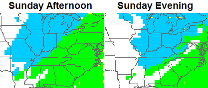
Our cold front swings eastward late tonight and early Sunday with crashing temps behind it. Winds will still be gusty as rain showers change to snow showers from west to east…
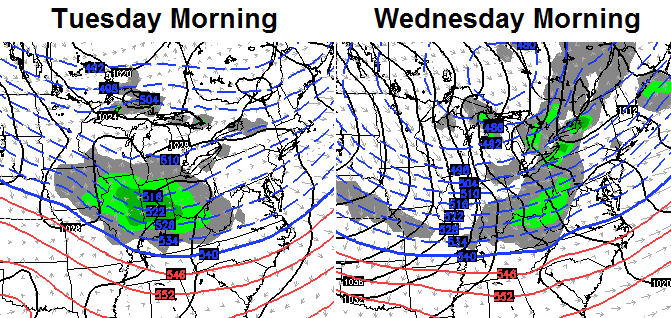
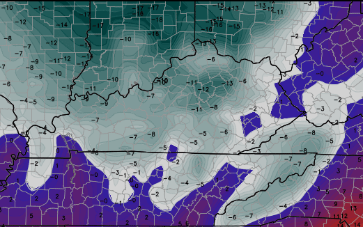
Temps by Monday morning will hit the teens with single digit wind chills. That brings us to the point of the arctic attack for the middle and end of next week. A clipper arrives on Tuesday with the true arctic front sweeping in early Wednesday. The GFS and European Models bring some flakes our way with those systems. The Canadian brings some out and out snows…
The real story will be the cold coming in behind that. Check out the numbers from the GFS…
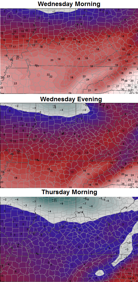
The Canadian goes even colder for Thursday morning…
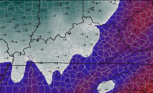
Gusty winds will accompany this arctic outbreak and that may lead to dangerously cold wind chills Wednesday and Thursday. Many models are now indicating widespread -10 to -20 feels like numbers…

That looks a lot like some of the brutal days we had last winter, doesn’t it?
A new trend in the models is for another arctic front to show up on Friday. The GFS and European aren’t as cold as the one you see above, but the Canadian goes hog wild with Saturday morning lows…
 I do NOT endorse that map, but it illustrates the extreme weather possibilities upon us.
Speaking of extremes… let’s track today’s wind and storm action…

Current temperatures

Sustained Winds

I will have updates later today. Make it a good one and take care.

SPRING SPRING SPRING SPRING SPRING SPRING…….Sorry Chris All I will be envisioning during the next 2 weeks is Spring, Warm weather, longer days,
I hate seeing all this cold showing up yet the only precip we get are spring like thunderstorms. Good waste of arctic air next week. Would be good if it had some moisture to share with us. GFS has the clipper missing us to the north. By next week temps moderate back into the 50’s. Hope we at least get some measurable snow sooner or later.
As a taste of things to come, already some lightning strikes at this early hour just west of the Mississippi River alongside Kentucky and Tennessee. Even some flood warnings in Arkansas.
But the highest severe thunderstorm/tornado threat will likely stay south of the Tennessee line. That said, Friday’s calm winds were somewhat surreal knowing that very strong gusts are just around the corner. Button down the hatches, everyone 😉 .
The latest SPC update has pushed the Marginal Threat of severe wx northward a bit, over the Tennessee Plateau up to the KY-TN line. Mainly a strong damaging wind threat from t-storms apart from the regular very gusty winds. The highest tornado risk remains well to the south.
Hope that clipper can dig a little further south and put all of KY in the all out snow and not just the river counties. No hype a week away I kinda like the looks of that. Thanks for the updat Chris.
I am as confident as any delusional mind can be in that this will probably be a yappy dog winter: All bark and no snow-bite. Book it. Well, we might get a couple ankle biters (maybe), but that is barking more than bite. Ruff!
For your seeing snow fix…Swan Peak in Montana on New Year’s Day
http://i.imgur.com/EoGIPRc.jpg
OPS (other peoples snow) SES (someones elses snow)
NMS (not my snow) I want my own snow 🙁
🙂
Thanks for the update, Chris. Our beloved Kentucky weather-you never know what you’ll get. Hope we get some snow soon!
I’m with you retro fetch.
Rodger says cold without some big snow chances is like kissing your sister!
That’s just great! Can’t wait to lose power tonight due to 50 mph winds, and then lose water next week due to frozen lines around the county!
Thanks for the update Chris. Sounding like we are gonna be bridesmaids again on the snow chances. ( you know always a bridesmaid, never a bride). That seems to be our part to play. Oh well, i guess we get what we get. I am glad that the days are on the side of getting longer though. That is a positive, for sure. Have a great Saturday everyone!
we need a good ol fashion ice storm since we cant get a snowstorm
No soup for you!
Cold and little snow. Not my favorite combination. I’m with some of the others on being glad that the days are cycling longer now. Not even a good snow showing up a week out right now. Hopefully the kiddos stay in school and get a long summer break.
Snow = Good
Cold rain = Bad
Extreme cold and dry = No thanks, I want spring!!
Go Steelers!
Go Steelers!
Everyone who says bank on no snow this winter is only speculating. I want snow as badly as anyone. When I wake up to a big snow,I am like a child on Christmas morning. One thing for sure is that it will be cold. Please remember to check on the elderly and bring your pets indoors please. The weather is what it is. I do love reading all the posts from everyone. Sometimes educational,but always entertaining. From Lucy pulling away the football,to it never snows anymore south of the river. My wish for 2015 is that all of us snow lovers are sick of snow before it is all said and done. I realize of course that we have to get our first good snow to begin with. Hopefully the party will start soon. God bless CB,fellow weather weenies and the CATS!!!!!!!
Will we be seeing any accumulation with the snow Sunday evening or next week??