Good Saturday afternoon, gang. We have a wild storm system rolling across the state this weekend and it’s going to bring some wicked stuff to town. Wicked takes on a much different tone next week into the following week as harsh winter weather shows up.
Let’s recap what to expect with the current storm…
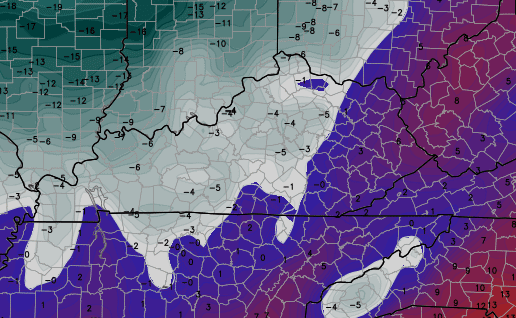
– Rain and thunderstorms will increase this afternoon into tonight. A line of storms will rumble across the region overnight as a cold front sweeps east. Heavy rainfall of 1″-2″ is a good bet for many. Locally higher amounts will be possible.
– High winds will also be a problem. Gusts to 40mph will be a good bet outside of any thunderstorms. That line of storms that moves in tonight will likely produce winds between 40 and 50mph. That could cause some damage.
– A dramatic temp drop will then take place from west to east Sunday. 20s show up from west to east from late afternoon into the evening. That’s when snow showers kick in and those are looking a little more widespread than earlier. Some minor accumulations will be possible Sunday night as temps drop into the upper teens. Wind chills by Monday morning will be in the single digits.
That’s how a harsh week of winter weather begins across Kentucky. But, it gets a whole lot worse as arctic air settles into town by the middle of the week. That comes behind a clipper rolling in on Tuesday. That should produce some light snow with the arctic temps arriving behind it on Wednesday.
Wednesday starts in the teens with tumbling temps through the day. We may be in the single digits by late afternoon and evening. Thursday morning looks brutal.
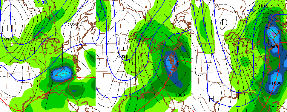
GFS

Canadian
Throw in the wind and feels like numbers drop to -10 to -20
 Yowza!
From there, the Canadian continues to drop an even colder shot in here late Friday into Saturday. The GFS isn’t as cold, but develops a system working our way from the southwest with some snow…
That’s showing some nice interaction between the active southern storm stream and the arctic cold that’s now across the country and Canada. The medium range models continue to show more and more of this over the next few weeks…
I simply cannot stress enough how this is a total pattern reversal from what we had in December. I said to think of this as more of the November pattern on steroids. That should have you pumped…

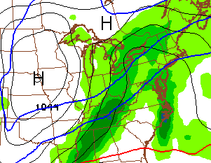
Here’s regional radar to track today’s showers and storms…

I will have updates as needed. Have a great day and take care.

Thanks Chris. Looking like some fun and games for sure coming up. Maybe the cold air can actually meet the moisture and make a good snow maker for us. Guess time will tell.
I am getting on the clipper mania train.
Hmm – I wonder if this winter will go like this –
Nov – cold/active
Dec – reverse of that
Jan – cold/active
Feb – reverse of that
Mar – cold/active
April – spring arrives
No mention of tuesday’s clipper? Guess it’ll be another snow (non) event.
No, you just missed it. It’s there.
He mentioned it clearly, you just read over that part
Clipper going well north of us. The snow drought continues
Don’t look now but the GFS is painting all kinds of ugly for next weekend. Freezing Rain, Sleet, and snow.
Yawn. More cold rain for southern KY. That’s how winter plays out these says, quick cold shots followed by cold rain. Not hard to understand this
Yah Bailey don’t be a girlie mahn and get some snow in heah.
With the cold coming in, Hans & Franz could use some help from their friend, Aaron Rogers, to pump up the snow volume over the next week or two. Kentucky is gonna feel like the Frozen Tundra might as well look like it too! Love that Hans & Franz!
Considering it’s Jan 3rd and I still have yet to see any frozen standing water, I’d say we’re over due for some harsh cold.
I was just outside squishing around in the ridiculously warm and moist ground in my backyard. It will be interesting to see how much of this snow will end up disappearing on impact no matter what the initial temp. It will take some of that brutal cold to get the ground temp to where it will happily accept and nurture snow fall.
I know the cold is the big story and it’s going to be a big shock to the system after today but there just hasn’t been much rain or wind today. I am sitting at exactly a quarter of an inch of rain since midnight and right now is the windiest it’s been today, which is to say it isn’t. Just warm and damp with some light drizzle. Heaviest rains seem to have been just to the north across Southern Indiana. That’s fine, wasn’t really looking forward to a couple of inches of rain.
Per Belski, today is the 37th day in a row without snow here in Louisville and I suspect it’s been longer than that for most of you. We had the 3.7 inch snow in November and just a flurry here or there since. None of the local stations has a chance of snow over the 7 day period which is okay as historically, the bigger snows don’t tend to show up till a few days out.
I know it’s going to get cold but if no snow by the 20th of January, I will be ready to turn the corner for spring and the return of sunshine, warmer temps and longer days.
KellyinLouisville – NW shift happens with the rain events as well. Now if this was a snow storm we would all be peed off. LOL. Cold and snow are a coming. Just be patience.
I know the cold is coming but not optimistic on the snow part. I for one am glad that I didn’t get all of that rain.
Kelly, I’m done with winter. Mailed it in after seeing the usual pattern-cold rains, cloudy skies, and 40 degree weather. Plus I’m still feeling the lingering effects of pneumonia that I contracted in early December.
We will get a nice cold snap or two, as that happens every winter. But prolonged sub freezing weather and shots at a good snowfall just isn’t happening. At this point, I think some in KY will be lucky to see a couple of minor snowfall.
I’m ready for getting on my bike, grilling out and putting a garden out.
I’m going to hold out hope for a bit longer. I’ve got a ski trip the first week of February to my old home of Snowshoe, West Virginia and I really want some powder. If nothing happens by then, bring on spring. I’m already planning out my garden for spring and dreaming of the late sunsets.
Results pump me up.
think ice ….that always makes things interesting
I remember one year, may been 2004 but cant remember, was maybe half inch snow that winter here in clay co. This year do far could be winter in least snowfall ever, but, we still have jan and feb to go. One biggest snow events in years was feb 18th or so 2012. About 5 half inches fell during daylight hours on a sunday afternoon.
In part of Richmond we are at 0″ of snow so far this year. Could be a record setting year the way things are going.
Dont think we have had much excrpt dusting on cars once in oct I think. Winter 93 was whimpy until superstorm. We still got hope of chris’ extreme prediction yet.
this current storm does not seem to be doing much aside from an early pre noon rumble of thunder it’s been mostly breezy drizzly rain showers nothing like the 40-50 mph squall line and heavy rains predicted for days another forecast bust or over exaggeration
do u like commenting here ? lol
I second that Upslope!!!
Bjenks, Upslope is mocking CB. CB said the same comment to Upslope a couple of blogs ago about being negative and somewhat trolling.
oh my! did I set myself up for something? lol.
im not trolling …ive been reading these blogs for years ….everyone should be entitled to their opinion , just bc its not popular shouldn’t matter
just my observation is all. it would be interesting if at some time it would be addressed as to why things didn’t exactly come together as forecasted as opposed to brushing it aside and on to the next thing.
Yeah, today was nothing like forecast by just about every weather source I saw. Just some light drizzle and a few isolated and very brief bursts of heavier rain. Just over a quarter inch for the day. I haven’t seen the wind blow at all today. To be fair, a lot had to do with where the rain set up. Just about 15 miles north of me in Southern Indiana they had almost 2 inches of rain while we have had very little south of the river. When I got up this morning I was fully expecting a deluge but so far and based on the radar, just drizzle and scattered showers.
Well said upslope. Comment sections on blogs are for opinions and back and forth. As long as everyone keeps it civil it should all be fine.
Except in this case… I’m tired of constant complaining from people and people acting like jerks sometimes. This is NOT facebook! Facebook has caused people to lose all filters they should have in a respectable society. Just because everyone has an opinion, doesn’t give them the right to be jerks to people who do nothing but provide them with constant information.
I don’t see anyone being a jerk on here, just some back and forth discussing the weather. I get that this is for the whole state, just stating, like several others here, that today didn’t pan out everywhere the way forecast were shown.
I certainly wasn’t criticizing you or your forecast, I acknowledged that many places did get the heavy rain, just not where I lived.
But whatever, it’s your blog and I respect that and won’t come back. I’ve enjoyed hearing and reading what people have to say on here. I respect what you do and I think you do a pretty good job but taking criticism isn’t one of your better qualities. As Darren said above, never any discussion about why things didn’t go as expected. If you are looking for nothing but cheerleaders, have at it. I’m sure there are plenty of people out there willing to do just that.
I wasn’t implying you were being a jerk.
Kentucky is a big state. That’s what this blog does… we cover a whole state and not just one backyard.
Thank you Chris for all of your hard work and dedication to this weather site! I’ve been turning to you for many many years and I hate the negativity in the comment section. Please ignore it! Obviously they know you are the go to weather forecaster or they wouldn’t stop in so much!! I agree that this isn’t Facebook but some just don’t have the filter!!
Well, Henderson KY has had 1.54 inches of rain so far. Morganfield KY 1.39 inches. Paintsville in east KY 1.21 inches, and it’s still coming down at a good rate in east KY as well as east TN. A recent tweet of 1.29 inches fell within two hours in DeKalb County TN east of me.
Multiple reports of gusts over 40 mph in KY, including Calhoun, Marion, La Grange, Harlan, Morganfield.
Sure would be sitting pretty if we were in Kansas right now. Cue the Wizard of Oz!
Here comes winter! We will be wondering how we ever doubted in just a few days! My knee is saying ‘brace for snow!’
Winter? Looks like a quick shot of nasty cold. A couple days in the teens and 20s. Other sources I’m reading, including Accueather, which despite it’s unpopularity, isn’t half bad in medium range,is going with WARMTH next week. 40s and 50s look like a possibility.
Starting to wonder here if <10" total snowfall amounts will be widespread throughout KY this winter. So much for 1977-78.
This is your last chance. I do NOT care what your “other sources” are telling you
This is NOT facebook.
Chris I wish we had the old blog back
Facebook really bugs me. People think they can be jerks about everything now days. What happened to good old fashioned common folk that would give you the shirt off your back? I grew up around those kind of people and now it’s getting few and far between.
Please be nice people. Chris has put out his forecast. Let’s discuss it nicely and be civil. If you don’t like his forecast then go look somewhere else.
I meant to say shirt off their backs. Lol
Fine. Not posting here sure won’t cost a minute off my life. I fail to see where this has become like Facebook. No foul language has been used, no personal attacks. This is nothing like FB.
Those of you wanting the “old” blog back, well you criticized and put down guys like WXMan and the forecaster from the NWS in Louisville who often posted during Winter. They were knowledgeable guys, but Katie bar the door if they disagreed.
You guys can have the cheer club, and hold on to delusions that a repeat of 77-78 is on the cusp
For what it’s worth, I agree with you.
Yeah, I’m right there with you Bryant. If you aren’t a cheerleader on here you might as well forget it. Criticism or discussion is not allowed around here.
Discussion is great!! Educated discussion! I love it but constant complaint is ridiculous!
That’s very uncalled for.
It seems Old Man Winter’s no show this year, is leading to a lot of frustration. Tempers rising as fast as the temperatures. I have lived through these snow drought seasons in my area several times, most happening in the last 20 years. Only good thing, this year is we have plenty of company. Two thirds of the country are experiencing the same thing.
Winter just started technically little over a week ago. Everyone needs to calm down. It is what it is. Chris doesn’t control weather he just forecasts. If you want snow then start praying and humble yourself. Lol
Mr. Bailey, I have been following this blog since last winter. This is my first post. I want to thank you for the amount of time you devote to this site and keeping us informed even if things don’t always go as planned. You do a great job of trying to give everyone in the state of KY as well as surrounding states aware of what could happen. I live in western ky and follow multiple weather sites but you are by far the most reliable and report more in depth than any of the others I follow. Seems there is a lot more negativity on here than usual so I also applaud you for taking a stand on it. Thanks for all your efforts.
Chris… I think you have warned everyone of the pattern that has and will continue to evolve into a more favorable pattern for cold/ snow …rough getting it to this point.