Good Sunday, everyone. Temps are tumbling across the bluegrass state as we get a little preview of what’s to come this week. Bitterly cold air is on the way to the bluegrass state and this will get close to rivaling some of the brutal stuff we had last winter.
Thermometers start today on the mild side with colder air working in quickly from west to east. Readings will drop into the 30s this afternoon and early evening with 20s by late evening. Snow showers and flurries will kick in during this same time… especially in the central and east.

Highs on Monday will be in the 20s as we await the arrival of a clipper on Tuesday. The best chance for light snow from this will be across the northern part of the state. The true arctic front arrives early Wednesday morning and could produce a band of snow showers and squalls. The Canadian Model continues to be the most optimistic on that…
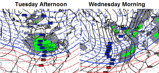
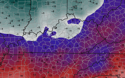
Temps Wednesday drop into the single digits later in the day and thermometers by Thursday morning may drop close to zero or below…
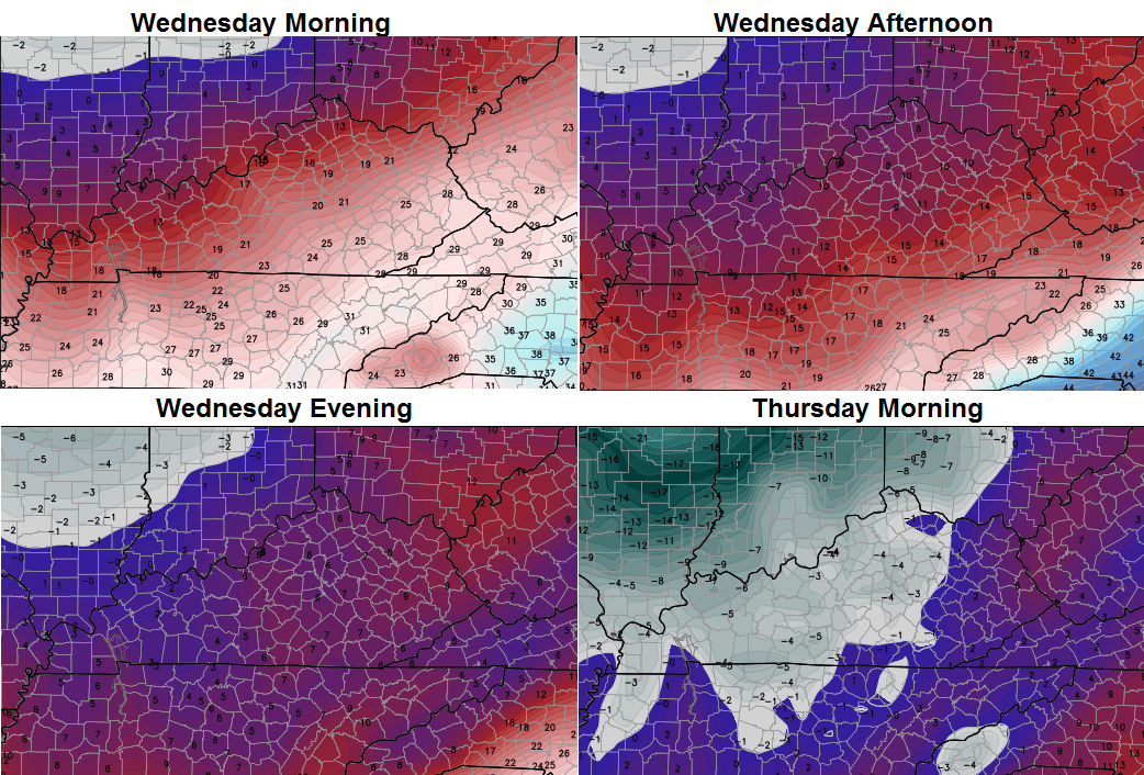
Gusty winds will make it feel MUCH colder than that with wind chills from -10 to -20 possible.
The models are split on how cold the next arctic front is around here. That arrives later Friday with the Canadian continuing to go super cold by Saturday morning…
Other models are not that cold and would give us the possibility of a snow system sneaking in from the southwest.
I’m not sure if I will do any updates today or not. Make it a great day and take care.

The good news in instead of a snow for us Direct TV folks is the games Sunday are not on WLEX 18. Winning!
Have a good day CB & thanks!
Giving you the benefit of the doubt, as I know you’re old enough to understand that WLEX-TV can be viewed over the air for free with a digital capable TV or attached device, but I’m absolutely shocked by the number of people on social media around here who can’t grasp that they can still watch their local affiliates no matter what happens with a carrier’s negotiations.
Not true the signal has limits not everybody can
Sadly -this. Not to mention having to hook something else up outside and pay for a hi def antenna. Moot, since my boss already okay-ed the DirectTV dish and refuses another thing stuck outside on the wall. Unless me 🙁
Hey Bubba, try building a fractal antenna. You’ll still need to buy a balun but everything else you probably have laying around the house (I used clear packing tape instead of spray glue). It’s pretty unobtrusive so the boss might not even notice (taped mine to the back of the TV)…
Plans here
Really sucks that you guys are discussing what TV channel you can or can’t watch and not the weather….and now back to regular programming….lol
Artic air and no precip sucks! Hopefullythis clipper can dig deeper into the south.
Discussing rain is boring
I respectfully refer to my boss as the warden.
🙂 ……….. 🙁 ………… 😉 …………………… 🙁
I us a standard antenna in my attic and run the coax cable as an auxiliary input into my Dish Box. I get the local channels in HD for free and the benefits of the DVR for them as well. I have been doing this for about 8 years. No one sees the antenna and I get all the local channels and their sub channels for free. Works for me. (Oh – I live in Richmond.)
I’m as disappointed as anyone about the true lack of winter weather to this point.
However, to put things into perspective, places like northern Illinois for instance have had only 2″ of snow so far. Louisville officially has 5.9″.
All it takes is one big snow…even if it is in March!
We got spoiled last winter with all the active winter weather to track. (Yes, I know this doesn’t include southern/eastern KY).
I think everyone knows how most of you feel by now, in regards to the lack of snow. I wish we had snow every other day. But, I don’t repeat it on a blog day after day. Give CB a break.
Much agreed with you. Chris gets so much undeserved grief it’s unreal.
Today I learned that living in Madison County places you in Southern or Eastern KY in terms of winter weather. This is going to make radar monitoring rather confusing going forward. I hope Bubba sees this as he’s also in the same boat.
Same here (South Chenault area of Richmond). 😉
The river… the river…. it creates a lot of “meh” for snow results.
But BubbaG, I live on Lake Cumberland! You’d think with it on two sides of me I’d get a little snow love it something besides a cold rain! Oh wait, that’s probably why it diverts into Tennessee and parts south!
🙁
The river, the bridge the curves and hills…maybe we can get a used snow making machine from up north and crank it up next year if this does not verify to our satisfaction! Widely scattered snow!
As someone that works outside, I will say working in the cold is not to bad. 0 degrees is not so bad, if it is dry. But I would prefer 50.
I should have added working in zero degrees is not so bad with the right winter gear.
I don’t normally post on weather blogs, but when I do, it’s to defend Mr. Bailey. The information on here is merely speculative and not the word of the weather gods. Personally, I come here to learn more about weather. That’s it. Chris takes a lot of his personal time to provide info. He keeps it real and subjective. If you don’t agree with it, don’t read it. Stop all the bashing when the weather isn’t to your liking.
See Chris Bailey, this is why you need a “Like” button!
Like like like like like like like!!!
Go Steelers
Vinny they lost….now you can pull for the Cowboys! Go Dallas…
Yea, we played soft all night. Good luck with your Cowboys buddy!
Go Steelers
Thanks Chris. Please know you are the man when it comes to weather forecasting. My family and I truly appreciate the work and fun you put into this blog.
It’s January 4th.We’ve got several weeks of winter coming and the snow chances should follow.
Good Sunday to all!
Thanks Chris. I hope at some point to see a good snow but that’s not up to Chris. He just calls what he sees. If he controlled the weather, we’d all be happy snow campers!
After last winters heating bills I’m ok with less of a winter this year.
Anyone else’s comments getting cut? Half of my last one disappeared! I meant for it to say Chris is the best in the business and he is who my family turns to for weather! That and Go Bengals!
Geez! What is wrong with you people? Can’t Chris just forecast snow so it will happen? That’s how it works, right?
Man, that’s a chilly forecast for the upcoming week! Brrr!
Coffeelady, I’ve been having the very same problem. Wonder what’s up with that?
And for all you snow lovers…….be patient. I know you want and need snow in your life. It will come. Maybe not when you want it though! The weather is wild and wacky and has a mind of her own. Chris does a great job trying to make sense of it all. As much as I hate the cold, there is nothing more exciting than a good impending snow storm (well, other that severe weather!). Hang in there everyone!
Same probl
em here. Just kidding 🙂
I really and truly appreciate CB,but sometimes people just need to vent. 99% of the time it not towards CB,but the weather itself. Sometimes it is the only therapy some people get. We love you Mr Bailey…
CB, try not to let the negativity get you down. You’re great at what you do, especially when your field of expertise is one in which will never be a able to be accomplished with 100% accuracy by anyone or any machine. Humans inevitably complain when we don’t get what we want…granted, some here go way too far with that when they blame you directly or indirectly. Ignore those idiots! I’ve done my share of complaining as well (without blaming you) but have since come to grips with the fact that the climate has in fact shifted and cold rain is the new norm for winters here in southern KY. Why continue to complain about something that cant be changed. The problem is that those of us in our mid 30’s and older remember what a real winter always brought been we were younger…several snows per year averaging 4-5″. We all miss that feeling from our youth and now it feels lost in the past.
I agree.
The only thing with some of the “complaining” on here is that it starts as soon as CB shows a model or map with snow. And even the “non-complaints” are repeats of the same stuff. And if it snows it seems the posts die down for a bit. Until the next showing of the models with snow. Was like that all last year and the year before. Just has gotten worse.
Sure, we may not get the snow that we want. But November was colder. Was a good start. Even early December was not to bad in terms of colder weather and forecasts were being busted with lower then predicted temperatures. And that was early. Not really a time in which we typically get much snow. And as soon as the models hinted as snow it was on though.
Bailey does a great job by my account. Not so great leading up to Christmas but nobody is perfect. I watch a lot of forecasts and seems that more times than not Bailey is the outlier. The others eventually move to what he was hinting at or showing.
You are misunderstanding my post. I am not jumping on Chris. I know of no one who forecasts upcoming weather events any better. He is the best. What you are seeing is tongue in cheek stuff from some of his earliest followers at the blogs beginning. It has become a joke of sorts because we always manage to miss a good snow. The weather is indeed wacky, but Chris doesn’t control it any more than I do. He is tops in my book. Always will be. Sorry Chris, if it seemed I was complaining.
Coffeady, this post was in no way. shape. form. or fashion directed toward you or any of the other long tome “respectful” posters. 🙂
I’m okay with the mild weather we have been getting up to this point. Would much rather have this than cold and no snow. It’s not like we have been getting hammered with big snows (the last decade and counting). I’m kind of surprised not to have seen some more days with at least a little snow up to this point. I’m hoping that winter doesn’t stick around any longer than it is supposed to. I wouldn’t mind a big snow or two, but let’s not keep it cold and dry any longer than we need to.
CB, keep doing what you are doing… I enjoy your comments and I’ve learned a lot from this website… I look at it at least 3-4 times a day and sometimes more… Thanks for all you do!!!
Do we need the cold weather?no.myself I’m not a fan of cold weather.do I need or want cabin fever?no.
We need cold weather to help control bugs
Didn’t help much last year.
Helped me a ton this year didn’t have near as many eating on the garden
The cold don’t get rid of rabbits or squirrels….lol
Shotguns do 😉
Yep! More food on the tale. Need meat with them greens…
Table
yeah, it helped with the bugs. For some reason bugs have always loved me. Especially mosquitos. This year was not so bad for a change.
Most of my comments are a lil less than positive when I post, but it’s not directed at CB I think it’s awesome how he uses his time to update the site. My frustrations come with a lack of snow, for folks who feel like I do…. All we can do is vent cuz there isn’t anything any of us can do to change it!
definately some snow showing up on radar in Indiana ….get that to swing in here might be nice
Or if it acculates it could help push the Tuesday clipper further south as lows follow the snow pack
Accumulates
The trend with the models today except for the NAM has been to track the clipper system for Tuesday further south. Not sure if that trend will continue.
Not real surprise to see the models trend southerly with the clipper system for Tuesday. Alberta Clippers are nightmares to forecast there chaotic and have a mind of there own.
What do the Bengals during playoffs have in common with models outlooking snow for this area? Both consistently fail.
They are who I expected them to be the weather models and the Bengals.
Kinda sounds like the Cowboys!
Who dey? Anybody if you play us in the playoffs
Def colder up here on the ridge in Greenup ky…spitting snow too
I am depressed. Was hoping to squeeze out snow day tomorrow. Evidently all this is happening later than expected or we just aren’t getting any. Chris is the idea of minor accumulations gone now for tonight?