Good Monday and welcome to a week in the deep freeze. With the potential for temps going below zero and even lower wind chills… the air for the middle of the week qualifies as dangerous in my book. It’s a good time to go ahead and winterize your car and home before the bitterly cold stuff arrives.
Let’s talk about where we are now before we get into the frozen part of the show.
Temps today are plenty cold enough with many areas in the teens this morning. Wind chills will be in the single digits, so do bundle up. Afternoon readings will only make it into the 20s with late day clouds increasing.
Those clouds are ahead of a clipper moving into the Ohio Valley tonight. That will send a stripe of light snow across the northern parts of the state and could cause some accumulations. Here are the areas most at risk…
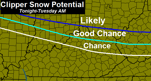
There will be a sharp cutoff on the southern edge of the snow, so we will have to wait to see how the radar looks this evening to see where that sets up. The “Good Chance” area could certainly see snow on the ground by Tuesday morning. The Likely folks north of the state could see totals approaching 4″.
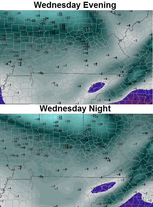
That zips away quickly on Tuesday with gusty winds and temps spiking into the afternoon hours. That’s ahead of our arctic front that sweeps in late Tuesday night into Wednesday morning. A band of snow showers and squalls may accompany this front and the GFS is now picking up on that…

With that much cold air and gusty winds accompanying the flakes… Wednesday morning could get a little interesting for some areas.
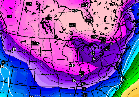
The arctic air then settles in with falling temps all day long. We start the day in the mid teens and drop from there. Single digit readings show up by the late afternoon into the early evening. It will feel below zero during this time. Actual low temps by Thursday morning will range from -5 to 5 across the state.
The wind chills will steal the show…
That’s nothing short of brutal and places our region firmly in the danger category.
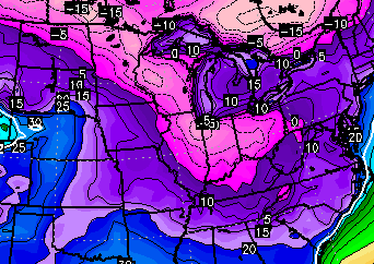
Another clipper arrives on Friday and could bring some flakes with it. The air coming behind that is trending colder on the GFS with single digits showing up Friday night…
The Canadian continues to advertise another below zero night…
From that point, we will be watching a southern stream storm system coming together and that may impact our weather late this weekend into early next week.
I will have updates later today… or will I? I only had the chance to update once on Sunday and the number of clicks was closer to what we get for a severe weather day. Haters… you lose, again. 😉
I’ll check back later today. Make it a great Monday and take care.

Thank you, Chris! Have a great day!
Thanks –
Thanks Chris! I look forward to your post and emails!
Thanks for keeping us up on what look to be dangerously cold temps. Look forward to your updates. Thanks, again.
Thank you CB and God Bless…everyone have a great day…
“How many clicks does it take to get to the center of a tootsie roll pop? The world may never know” or “First World popular website problems”.
If things are getting this ridiculous now, I can’t imagine what it’s going to be like when we start having to deal with actual accumulation forecasts and the resulting totals.
Good god man, no one is ‘hating’ on you personally. The only people who actually offered professional criticism (i.e. they were educated themselves as mets) haven’t been here for a long time, and even then it wasn’t “zomg haterz lol yolo” types of communication. Professional or Non-professional people discussing factual data or interpretations and methodologies of such, isn’t ‘hating’.
Think of an aspect of your duties of hosting this place as akin to that of a bartender who listens to everyone’s weather problems (and other things masking themselves as weather problems) and keeps pouring as they listen. Bars are full of complaining but it isn’t truly directed at the bar or the sole bartender. If it was, they’d go to another bar and complain about it there. Everyone keeps coming back to the bar, so that should tell you something. It really is that simple.
Okay? Okay. No more persecution talk and let’s all happily move forward from here and all be Joe Friday to the best of our ability.
Well since the title of his blog is Kentucky Weather Center I guess it still covers Northern Kentucky, where we look to be getting some snow accumulations (hopefully) tonight. 🙂
Huh…Apps no understand this hater..He speak forked tongue..
There is near zero chance for this post to have a positive result…. I could say the same thing about mine too but digress…….
There are a LOT of folks that read this blog, so CB needs to control the content- Especially when kids read this blog who BTW can not go to a bar 😉
You are overblowing this big time.
It’s just that people need to vent……we see it all the time……when it doesn’t go right, they need someone to blame….and now more than ever they can with technology and the internet…….Remember those busted forecasts in the 70s or 80s…….We all wanted to know “what happened” Why did you say it was going to do this and then it didn’t? You wanted to scream and vent but couldn’t like we are able to now……..disappointment and someone to blame for it is all it boils down to ……
True that people need to vent. But you have to admit this stuff starts way early. When models where shown in November the first thing I read was certain people coming out to post the negative posts. And it is the same stuff.
Venting is one thing but when you are constantly negative from the beginning it can come off as a little more than that. Not saying it is just that it can appear that way.
The worst part is you can predict which posters it will be and pretty much what they will post. Not to mention that the number of posts drops a lot when things work out.
Of course most people could just look at the poster name and avoid those posts. I do most of the time on certain people because I know what they are going to say.
And by the way I have never once heard Chris accuse anybody of persecuting him.
Thanks Chris. Been home with the flu for the past few days, but not looking forward to going back to work in those temps! Long johns are gonna get a workout for sure! Have a great Monday everyone and stay warm!
Wonder if we get one of them clippers swoop down more south? I hold no faith in the southern feds, since they have only been big-ice for a very long time for a lot of us. Ice is only good for my Pepsi 🙂
I guess it’s possible. Heavy rain was predicted but it stayed much farther north and west a few days ago, so I guess there’s that possibility this could do the same thing ….
My rain gauge begs to differ I had 1.44 inches of rain in about a 12 hr period that’s pretty substantial
Hope the flu was not too bad. I have not had the flu since I can remember. Only thing that happens to me when I am around people that have the flu is I get extremely hungry. But I have seen some people who are real sick with it. Hoping that was not the case with you and you are feeling better.
Thanks Chris for the awesome job you do. Please tell old man winter to take it easier on us this year.
Thanks so much, Chris.
The cold is really here…brrrr. And gonna get colder still. I like my brisk weather but this is a change for sure.
Cold in place and then some snow! Let’s hope so.
i wonder with the southern storm possible early next week will raise the temps up to the cold rain senerio …the trend says yes , trend buster? I guess we will see
Seems a lot of these storms are like this. If they come from the south they tend to warm us up. We need one far enough east but not to far to throw that moisture into the cold I guess.
i wonder with the southern storm possible early next week will raise the temps up to the cold rain senerio …the trend says yes , trend buster? I guess we will see
A priest, rabbi, and a preacher walk into a bar. The bartender ask, is this some kind of joke?
Pattern is screaming big ole ICE storm sometime down the line..Hopefully we are in the cold rain variety if it does hit..
The reason I do not like southern feds and why folks should watch out for Lucy- Not a football, but a big solid piece of ice she will let you kick. Ouch.
All those BubbaG rains are borderline. All we need is things to work down a few degrees in the right scenario and that will give us some ice. It isn’t like we have not had ice in recent years. Just not real bad. Some beautiful scenes out and about with the ice in the trees. But those are light icings. No desire at all for a big one or a small one followed by heavy snow.
Look for several schools to be out Thursday or on a delay due to the cold temps!
Temps have dropped from 30 this morning, to 25 now and that wind ( it will cut you).
From the track of the clipper, it looks like about 3 or 4 days of DRY cold followed by a warm up and rain by Saturday.
Make a deal with you… come back here on Saturday and let’s see how warm that day is. 😉
Sounds good. I have ate crow before. Have you?
One more thing. I hope you are right on that forecast. I am a Winter Weather Lover but the local tv weather here in my area have upper 30’s and low 40’s for the weekend.
The southern storm, this weekend, will bring freezing rain to some here in Kentucky, rain for others and snow north of Louisville. The cold air is in place, but southern systems will bring over running warmth with them allowing for different precipitation types to occur. Plus cold air brings low dew points, that may keep precipitation from hitting the ground early on.
We`ll see. I just dont think we`ll see a lot of snow, this year here in Kentucky.
no snow much from looks of thingsd, itds the BUBBA buster 32 below no precip, above rain.
We need a Bubba buster and a Rolo-coster to break the trend!!! GO BIG BLUE!!!!!!!
Sunday-Monday screams Ice Storm. make preps now for lots of ice -most of central ky in line with lots of moisture from the gulf on this one. Prepare Now. You heard it hear first.