Good afternoon, folks. Our frigid week is off and running with actual temps spanking the computer model forecasts again. Readings this morning dropped into the low and mid teens and are struggling to get into the low 20s at noon. One can assume the same will happen with the “frozen tundra” blast coming in a few days.
Firs things first and that’s the clipper system impacting the region tonight. This system will bring a swath of light snow across the northern parts of the state and I have no changes to this…
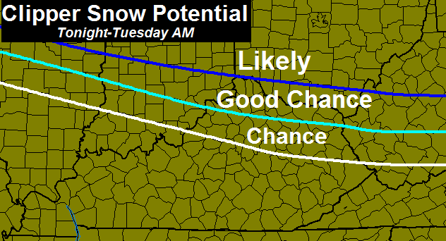
Areas in the “Good Chance” have a decent shot at picking up an inch or two of snow. Read that again… a DECENT SHOT doesn’t mean it’s a given.
The arctic front moves in Tuesday night and Wednesday morning with a band of snow showers and squalls…
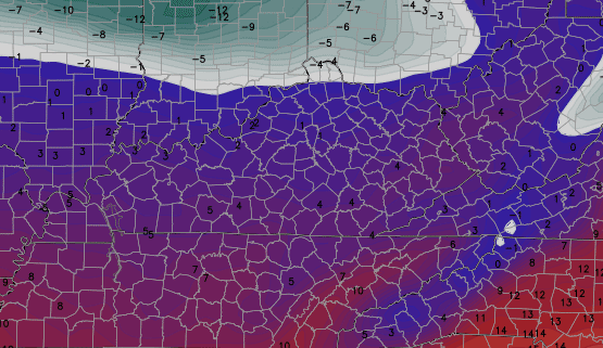
Temps fall hard behind that front as we start in the teens and see single digits show up from northwest to southeast late afternoon into the evening. Lows by Thursday morning on the GFS…
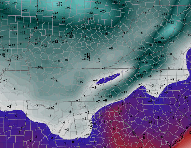
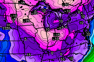
The Canadian continues to insist on many areas going below zero. -5 to 5 should be common across the state. The Wind chill numbers continue to look crazy…
Another clipper shows up on Friday and may have another round of snow showers and squalls with it. Gusty winds and falling temps lead to wind chills below zero for Friday Evening plans…
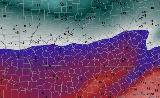
This GFS continues to trend colder with the air by Saturday morning with single digits showing up for many. The Canadian goes below zero…
From there… we watch a winter weather setup from late weekend into early next week.
I will have another update later today. Have a good one and take care.

It is 29 here in knott co with the sun out. Seky is on another weather setup then rest of ky. Was giving 30 here today so I’d think we will hit that pretty easy. I’m interested to see how cold we can go with out and snow on the ground
Started about 23 at my house in Knox this AM and its now up to 31 but we are not the majority so its not note worthy
Low of 24 here last night. Hit 33 today pretty nice day with all the sun
This year my New Years resolution was to go on a diet, so I chose the whiskey diet, I have lost 3 days so far
Hot cocoa time, snap!
Or a nice Irish Coffee! 😉
I see a traffic-camera-filled post coming soon!
No Chance…so that’s whatcha got!! Mr. McMahon would love that one.
Thanks Chris.
I saw that the NWS was still concerned with a southward trend in the models with tonight’s Clipper… anyone heard anything else about that? Looks like Chris is holding steady with a NKY event…
Hope everyone is having a Happy New Year!
Clippers have been our (south of 64) biggest snows since post 98. Southern feds are nothing but bad news for a lot of us.
Think clipper! That is unless you want power out due to ice from a southern fed. Boo!
i ll take an ice storm 🙂
Clippers are nothing but headaches to forecast always er on the side of caution with Alberta Clippers. These clipper systems are known to mess up a forecast radar is your absolute best friend for clipper events.
Hey Chris,
Any predictions on the clipper moving south? We live in Ironton, Ohio. Hoping for a decent snow, thinking it might move south. What do you think? We’ve watched your blog consistently since you left WSAZ. Still the best blog going!
For those who follow the MJO, there have definitely been some positive developments based on the GFS and a few other models. The GFS takes the current impulse into phases 7 and 8 by mid month and there seems to be good support from its ensembles. Phases 7, 8, and 1 are cold phases for out region. The Euro and Japanese models also get near phase 7 and 8, although they are both weaker.
The MJO did well predicting the warm up in December, but I’ don’t think it was the driving factor. The strong Pacific jet was the main culprit and the MJO just followed. Now, I believe (hoping) the same thing is happening. As the very favorable SST’s in the Pacific begin to exert some influence, the MJO seems to be following their lead.
The warm SST’s in Nino 3.4 and cool SST’s in Nino 1 are indicative of a Modiki event and usually delivers cold here. On top of that, the warm SST’s along the west cost and Gulf of Alaska promote a positive PNA. That means ridge in the west and trough in the east.
Late chiming in here, but I bet I’m far from alone in appreciating your posts! Thanks, Robbie.
To the north, the sky is very cloudy and a peculiar shade of bluish purple. I hope that means some snow is on the way. Here in NEKY we are due for some. Everybody keep your fingers crossed. Thanks, Chris for showing us we have a chance for some of the white stuff.
I always hate these cold outbreaks with no moisture involved, looks like Ohio will do pretty good out of this, maybe our turn is next?