Good evening, everyone. A light snow maker is working toward the northern parts of the bluegrass state tonight into Tuesday morning. This will likely cause some accumulations the farther north you live. It’s possible to get some flakes to fly all the way to the interstate 64 corridor. Possible is the key word.
It’s an evening of radar watching to see just how far this system can get…

The arctic front arrives early Wednesday morning with gusty winds and likely snow showers and squalls for some. Temps behind the front tank quickly with single digits showing up late in the afternoon and evening. -5 to 5 will be possible by Thursday morning.
Wind chills steal the show…
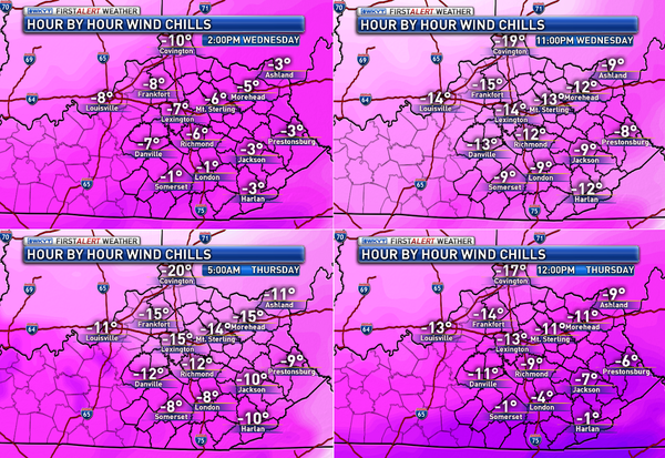
Those forecast numbers are just flat out brutal if they verify. Wow.
Another arctic front swings in Friday with the potential for some snow showers and flurries. Single digit lows will be possible again Saturday.
The southern stream system I’ve been watching from late Sunday into Monday continues to show up in some fashion on all the models. The European Model is seeing it…
I will have a full update and some tracking toys later tonight. Enjoy the evening and take care.

BRRRRR!!!
The pattern has certainly become a little more exciting for winter lovers around here. Here is to hoping it is a sign up things to come.
Thanks Chris for the regular updates! We really appreciate all you do to keep us informed.
of *
Clipper stops at the river….imagine that….and the euro has snow a week out….imagine that…came down with the flu over the weekend and I have not been sick in at least 10 years. Chills aches fever really sucks….like our weather….thanks for the update CB…..bundle up everyone it is a coming.
Hot tottie time….
Crossing the fingers that we get an inch or two up here in Boone County (Burlington). 🙂
Somebody please lift the Dome at the KY border! Snow is out there……Somewhere!?! All we need is an evil snow grinch to howl with a big ol’ horse laugh.
I have to laugh at the radar right now because it no joke looks like something could just be standing there with a shield deflecting the snow right at the Kentucky border. Like, “HALT! You have reached the land of the snow dome and thou shalt not enter here.” Boo on that.
Lol. That’s how I feel about Richmond Va. There is a dome where Richmond gets no snow, yet 10 miles north and west gets it all. Occasionally the South and East will get snow, yet once again Richmond get nothing.
Maps without legends, come on Chris. You’re better then that!
No big deal. Chill.
Unfortunately, my smiley face icon didn’t stick 🙂
Son, please don’t tell me to “chill”. You don’t know me…
Don’t call me “son”. I don’t care who you are.
Well im off work tomorrow and since the snow will not come to me in thinking I will go to it. Only a hour and half drive to Indianapolis and a one hour drive to Cincy from where I’m at.
Head to Indy like right now before you get into that mess.
We have very fine, light snow reaching the ground now in Northern KY. It is almost dust-like.
Clipper looks like miss. Then dry cold for the rest of the week. I am not excited about that southern system this Sunday. It has rain and rising temps written all over it. Those southern storms look good a week away this year. But then fade to warmer and rain.
Accuweather now saying a coating to an inch for Richmond. Is this thing going to dive south?
There’s your first mistake (Accuweather) enough said.
Thought it was interesting that they have shown nothing all day up until a few minutes ago.
Yeah, Accuweather would not be my first choice. But then they are right sometimes.
It almost, at least on the radar, look like this thing may get a little farther south. Back edge of that thing looks like it is filling south and may just get far enough south for snow south of Bailey’s chance line by a little. Would be nice to see a surprise snow.
Possibly but doubtful. Looks like a over running situation for Sunday into Monday. Artic air is very stout models always struggle trying to scour the artic air way to quickly.
We could be like It’s a Wonderful Life and use cornflakes for snow.
That is what they used for snow falling, since black and white made it look like snow. Got milk?
Rodger sees snow further south than predicted. All eyes then on weekend storm chances.
Roger easily influenced by Lucy and her football.
😉
Verga storm in frankfort, radar looks good but nothing falling 🙁
I believe the next dog I get I shall call Verga…why not. Lol