Good Tuesday, everyone. A glancing blow of light snow will quickly work out of northern Kentucky this morning and then it’s time to focus on the arctic attack on the way. We have, at least, three days ahead of us that will feature single digits or lower. The wind chills will be even colder than that! Brr!!
First things first and that’s tracking the morning light snow in the north…

I-71/I-75 at I-275
Near Covington

I-275 at Mineola Pike
Near Covington

I-275 approaching KY 20/Airport
Near Covington

I-71/I-75 at Buttermilk Pike
Near Covington

I-471 at Grand Ave.
Near Covington

I-471 South of US 27
Near Covington

The arctic front moves in here late tonight and early Wednesday and may have a band of snow showers along and ahead of it…

Temps behind that drop quickly through the day. We start in the teens with readings dropping to around 10 by the evening commute. Single digits show up during the evening with lows by Thursday in the -5 to 5 degree range. Wind chills during this time will be brutal!
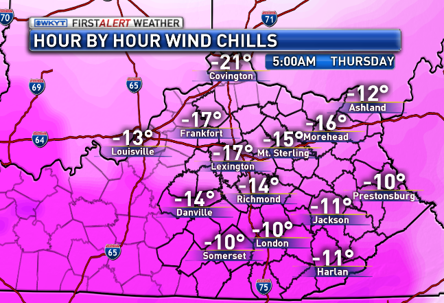
Those numbers are from the NAM and would rival some of the cold shots we had last winter.
Another arctic front arrives Friday with the potential for some light snow and flurries. Temps behind that drop into the single digits by Saturday morning. The Canadian Model keeps on keepin’ on with forecast below zero readings…

Temps on Saturday may struggle to get to 20 degrees.
From there… we watch southern stream moisture to see how it interacts with the cold air that’s around.
I will have updates later today. Make it a good one and take care.

It’s really depressing to see snow all around us yet again
I’m not sure what in the world happened, but as soon as I clicked “post comment,” the majority of my message was gone!
Call me an optimist, but I have a good feeling about Sunday night.
Here in Cincinnati/NKY we got only a light dusting. Even those in the WSW area just to our north only got a few inches.
Not a single flake near Ashland. 3 or 4 days dry and cold then warmup to rain this weekend. Southern storms have a disaster this season.
“Temps on Saturday may struggle to hit 20 degrees.” Not being critical of you, but who in Eastern KY is forecasting a warmup to rain for the weekend?
The trend says so, sorry!
It will not get above freezing until the precip. Comes, so yes sat. May below freezing, but the Trend forecast will be cold rain!
Unfortunately my stations come from WV. They have dry weather the rest of week, cold thru Friday. With the word Moderating and temps at 40 with big one raindrop on Sunday. No reason to doubt them it has been the pattern all season.
“only got A FEW inches”.
Yes, I’m sure all of our hearts go out to everyone caught up in such a time of crushing disappointment and suffering. I’m sure between all of the Red Cross stations being set up and the wave of forthcoming donations, everyone will find a way to cope and survive. I’m sure a telethon is being planned in Hollywood right now to help out as well.
Carry on you brave soldiers, don’t let this tragedy steal away that twinkle in your eye or that spark of awesomeness in your heart. You are our hope and our salvation.
Meh, most of Hollywood does stuff like that for politics, PR and tax reasons. Kindness is not normally one of their main motives.
I happily take nothing over a small snow that results in roads coated nasty salt. Winning!
I certainly hope your comment was tongue in cheek. Was just reporting what was on the ground with no wish for anything more or less or disappointment.
Nope, I know I was not and pretty sure neither was LD. Think LD might be having a “Shining” moment… Have to see the movie to get that 🙂
More like a “Flowers For Algernon” moment. 😉
No snow for you…..funny how the models that don’t show snow for Ky are always correct and the ones that have us in the snow always change. Still holding out hope for a few good storms to move through KY over the next month and a half. Dreaded southeast ridge needs to relax just a bit to get the souther fed storms to travel up the apps.
Think Snow! Thanks CB for the update…
30 degrees here in knott co this morning. Was 22 when I went to bed warmed up big time over night. So much for those teens I guess
Its already warmer now at 35 than It was all day yesterday in Knox County
38 here in Bell Co
Gonna hit 40s in seky today with ease.
Unless the trend is downward, not only will the Lake Cumberland area see 20 on Saturday we’re forecast to top the 30’s.
Rodger says weekend system looking either too warm or too far south with main precip. This is getting depressing. He also thinks Mr Bailey’s minimum mention of it this morning has him thinking the same thing. Rodger in Dodger
Nice to see Rodger leave the football alone 😉
We probably will be “lucky” to see a few 2″-3″ snow events this winter. Concerned though that ice from a southern fed could smack us this winter.
Funny, CB is calling it frozen tundra and I predicted that is what our winters would slowly become around here a few years ago. “Brilliant” in my own mind! 🙂 😉
Yeah you’re something else. Wish you’d start your own blog.
Would be a boring blog with the same stuff constantly. Would only need to visit once to know what was said. j/k.
I do see that even accuweather has my area hitting 0 tomorrow night. High of only 19. 20 for the high Thursday. Accuweather even mentions a snow shower. Not sure if that works out but maybe. I see that the forecast from them is now 20’s for highs through Saturday. Even the weather channel site has come around to the cold up through Saturday. For some reason they are showing snow, rarely happens this far out, for Monday-Wednesday. I am not up on their forecasts (they are wrong a lot). Waiting to hear what CB has to say.
The radar looked good last night but nothing really to speak of. Nice to at least see the radar with something on it though.
Like my little boy says ” you get what you get , and don’t throw a fit ” , but I am still holding out hope for some snow this winter , keep up the good work CB , love reading your blog
Holding out hope? It’s only Jan. 6!
Was there mention of snowfall tonight? Has that potential evaporated, or did I misread the last few posts?
Not sure. I did see that accuweather added it into their forecast for my area.
They also added in ice for Tuesday-Wednesday next week. Weather.com has snow Mon-Wednesday.
I am pretty much waiting on CB. He talked about this cold way before others were mentioning it. Some had mid+ 40’s before adjusting down. I just wonder what the models are showing and if he is started to heat up to the possibility.
It rarely snows down here on the tropics of southern Ky!