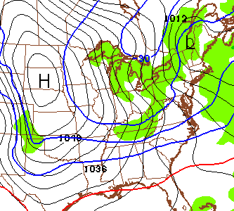
Good Tuesday afternoon, gang. The arctic surge is ready to push into the bluegrass state late tonight and early Wednesday. This headline making cold will then be reinforced by another arctic front arriving Saturday.
Tonight’s front will likely be accompanied by a band of gusty snow showers…
A plume of Lake Michigan snow shower action may follow that up and reach all the way into the eastern half of the state during the afternoon and evening.
Temps are the big story and will drop from the teens in the morning to close to 10 by the evening commute. Single digits show up during the evening and we keep dropping into Thursday morning. The forecast lows from the hi-res NAM…

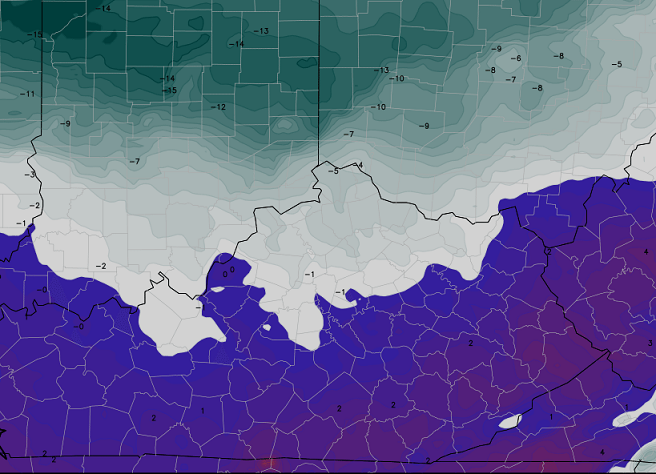
Single digit temps are forecast all the way into parts of the deep south. THAT is one heck of an arctic outbreak!
The next cold front arrives Friday with a few snow showers or flurries. Temps behind that drop into the single digits for Saturday morning with highs only in the teens.
Southern moisture then gets involved in the cold pattern from late weekend into next week. I get that your weather apps show temps a gazillion degrees… but they were showing that for this week, too. Weather app forecasts are useless and I don’t care which company they come from. Zero human input into those things!
I will update again later today. Have a good one and take care.

I really hope the Ky Snow Dome breaks soon. I haven’t seen a flake since Thanksgiving. I really want a big snowstorm! This getting cold and warming up stuff needs to stop. What happened to the winters where it would get cold and stay cold all winter long?
Hopefully not much wind with that cold air. Longjohns rock!
Last winter it got cold and stayed cold. Coldest one in decades..
I wish it would get cold in December and stay cold through atleast March. By cold I mean stay below freezing.
I want the Ohio River to freeze over again.
Ummm. Last winter?
My app actually showed a gazillion and one degrees for Saturday 🙂 Thanks for the heads up, Chris. We are trying to prepare our students for how to dress tomorrow. Be warm everyone.
A husband and his wife were sound asleep when suddenly the phone rang.
The husband picked up the phone and said, “Hello? How the heck do I know? What do I look like, a weatherman?” He then slammed the phone down and settled into bed.
“Who was that?” asked his wife.
“I don’t know, some guy who wanted to know if the coast was clear.”
That was a good one Axl. I’m hoping the snow dome and the snow grinch both disappear…soon!
Thanks Chris. As usual you are on top of all things weather.
Chris tweeted that bands of snow may make the morning commute bad…I wonder for which parts of the state???
The usual suspects 😉
Then not Southeastern Kentucky…lol
Kevin Spacey = 64 north 😉
be few school closing tom, snow looking stronger late tonite into morning.
EAST SE get best shot with upslope taking affect.
Only giving 10 to 20 percent chance for Harlan County…:(
Thanks for being reliable Chris Bailey ! I’ve been following for about 7 years now and I always check you first . I can remember when Lincoln was in high school . lol
I predict Richmond will add 0 inches to it’s seasonal total of 0 inches. We’ll see, I may be overstating things…
lol!
If there were a NEGATIVE snow total, Berea would have it. 🙂
I think 4″ total is a goal we strive for! 😉
The closest thing we have to the “frozen tundra” look around here is standing at the gas pumps at Costco in Lex. When we get a little snow on the ground and some good wind, it both looks and sounds like your wayyyy up north. It’s great.
Since this location is close to the WKYT parking lot, I shouldn’t be disappointed in the morning. 😉