Good Evening, gang. The air out there is nothing short of brutal and the numbers keep dropping as we head into tonight. This air has been well covered, so I’m not going to rehash every single detail. Lows tonight range from -5 to 5 with a wind chill of -10 to -20 for some.
Another arctic front arrives Friday with the potential for some snow showers or flurries. Another night in the single digits will follow that.
A very wintry pattern will then likely kick in from Sunday through next week. Southern moisture is going to get involved and the arctic air in place is NOT going to get bullied. That could set the stage for overrunning nasty weather Sunday through Tuesday. Freezing rain, sleet, snow and rain could all fall during this time. The GFS is picking up on this…
 Watch for a possible trend to colder on the models as the realize the dense arctic air that will be in place.
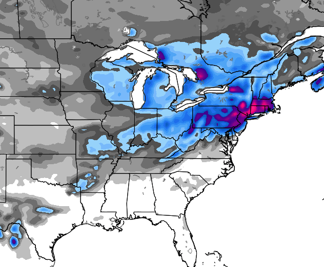
The models are following that up with the potential for another system by the middle of the week. The new version of the GFS spits out a monster up the coast…
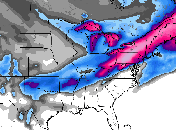
 If we look at the European Ensembles, we can see where it thinks the corridor of winter weather shows up next week…
We shall see how all that works out, but the pattern is certainly supportive of our region being in the winter weather zone. To what extent is the question at hand.
Enjoy the evening and take care.

I gotta question , if the arctic air isn’t gonna be bullied , but then the word RAIN ….so if its rain , it will be pushed somewhat away….back to bubbas 32/33 line anyway lol
It can rain way below the 32/33 mark.
Pendleton, our outside digital recorded -3 deg F overnight
Thanks Chris –
If only we at least could trust me models 3, 4 or 5 days out – unfortunately, we can’t. I guess we shall see what happens…….
Narrow, intense snow band has set up here in Perry Co. Really coming down.
Read between the lines folks. If the event trends colder, what probably happens will not be nICE. Bad stuff from southern feds and a trend colder could mean mainly ice for us river dwellers on south and mainly snow for 64 on north.
We want a warm direction for temps. Southern feds have been bad for most of us since post 98. True stuff.
Don’t like the last map. Shows the river counties on the lighter side of things. Do like the set up though. Wait and see now.
Only god knows whats gonna happen. I wouldn’t mind some snow. enough
The artic air seems to be always bullied by moisture….hope it hangs on this time.
Not this hillbilly. Name one time a southern fed since 98 has not been big ice for us as far as mainly frozen stuff.
Three letters if the cold air is around: WAA
Rodger says let the games begin. Warm moisture usually wins out over cold in our part of the world but at least there’s something to watch. Thanks Mr Bailey for all you do.
Winter. Ahhh. Took a great and very cold walk this evening. I miss days like today, and I am looking forward to next week’s shenanigans. Hopefully the fun sticks around for a bit.
NWS going with low 40s next week in eastern KY. As usual, we will see.
Yes, but they are using the Kelvin scale. 😉
Chris Bailey you rock how you got Fatette County Schools to reconsider and call off school I will never know! Chris Bailey for Pres! You got my vote!
“FAYETTE”
we had a cold 21 degree freezing rain in january 2013. was sad to see temps 21 and have freezing rain.