Good Thursday, everyone. Bitterly cold air is in place across the state today and I’m watching a reinforcing shot that shows up Friday into Saturday. This next blast may not be as cold as what we have out there this morning, but it looks plenty cold enough.
Temps this morning will range from -5 to 5 in most areas.

Wind chills will much, much colder than that and you should limit your exposure outside.
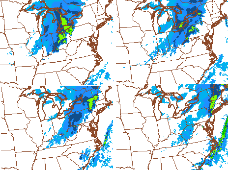
The next arctic front approaches the state from the northwest early Friday. This may have a band of snow showers and flurries along and ahead of it. The NAM and Hi Res NAM are more enthusiastic on those chances than many of the other models. Here’s the future radar from each of those models…
We will have to see how much snow shower action, if any, we can get from that. Regardless… another shot of cold comes in behind it with temps in the upper teens and low 20s Friday afternoon. Temps will then drop toward 10 degrees late Friday evening.
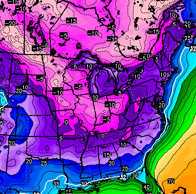
Saturday morning lows on the NAM are in the single digits with the zero mark getting into far northern Kentucky…

The Canadian keeps showing below zero numbers…
Wind chill numbers should be back below zero at times late Friday into early Saturday.
Messy weather then moves in later Sunday into early next week and I get more into that with updates later today. Make it a good one and take care.

Thanks CB. Awfully cold out. Ho
* Hope we get some good snow to along with the cold…
That word messy again .
It’s the new mix 😉
We Do Need SNOW to go along with this Cold. Several inches Please.
Bit of an over achiever in my area of Knott Co with about .5 inches yesterday
Had 0 accumulation in Carrie of knott co. Must just hit in spots
Hope the Friday snow is the final map above. Need a small snow pack when the southern system moves in. The colder the better…..for some.
Thanks Chris for the Update. Look forward to tracking the Sun/Mon event and into next week. And why was Fayette Co. Out of school today?
They were out, like the rest, because apparently the school systems trust neither the parents nor the students to have the common sense to dress appropriately. It’s apparently impossible to survive outside, if you listen to the media and the mets. I guess all of those times we walked to school or waited for the bus in colder than this temps and windchill in the winters of the ’70s must be some kind of miracle. I wonder why know one ever called the Vatican to get it made official and such? I mean how were the emergencies rooms not overrun with thousands of frostbite victims showing up like the walking dead? Amazing, I know.
There was a story last week on CBS Evening News where they were talking to kids waiting for a school bus in MN and the temps were subzero and the windchill in the -30s. They were fine. Hell even the kid who said he just moved here from “down South” was doing okay because he was dressed appropriately by his parents or himself. He had zero ‘acclimation’, so I guess he must be a superhero or something and it have nothing to do with his clothing.
Remember, you don’t need a heavy coat, you just need to wear multiple layers…
http://youtu.be/q–6wtCPHg8
Parents are up in arms here in Boone County because school is on a normal schedule today. Board policy is to close for wind chill only when there is a wind chill warning in effect,and we are under an advisory. My daughter does not ride a bus, but if she did, I would either drive her to school or wait in the car at the bus stop. Apparently common sense has been replaced by common core.
Gotta love folks who act like they are superior to others because they are “tougher” than others.
Is there anybody on this blog you don’t criticize?
And I was hoping Bryant got banned. I guess he was getting his blowtorch repaired.
Jeff is the one who should be banned. He personally attacks and insults people.
That is a false comment and you know it.
Others know it to be absolutely true.
Except for one thing: it’s not. 😉
Yes Bryant there is: people who don’t act the fool.
I’m sure that’s aimed at me. Despite the crud I get, I don’t attack others like you frequently do. Keyboard warrior you are
I agree LD.
Then again I like to see the schools error on the side of caution. At least in my area. And it is only one day. Would I be upset if they had school, no way. But I have seen a bus break down while children waited for it and had no idea. And not all the parents around here provide the best clothes for their children whether is it because they can afford them or not. And you can bet that if there is school their child or children are going even if they go in t-shirt and shorts. They need that time away from them and that is entirely what it is.
On another school and weather note. I remember once in middle school (right after we moved here from NW Ohio) were we had school and the roads were icy. Took a long time to get to the school. We actually slid and had other issues. And when we arrived we stayed at school about 45 minutes and they sent us home. They had buses stuck all over the county. And even after I graduated there were some similar instances a few times. Most thought schools should have been canceled at the time but the schools tried anyway. Good to see them realize that it is just one day of school and can be made up anyway.
Oh boy, here we go with this same old stuff that happens every year when schools let out due to cold. Smartest men in the room are experts on education systems and the effects of negative wind chills on children and buses. With so many experts out there it’s amazing our society has not advanced further than it has.
2 here in Carrie this morning. Calm wind actually feels better out then yesterday’s blustery winds
Look for an interesting Sunday-Tuesday with the southern moisture dueling the cold in place and a wild card of another cold high that might reinforce the cold just enough. Rodger thinking more ice than snow, however. Rodger traveling to and from northeastern Ohio this weekend so hoping he gets back before it gets messy.
If the cold air is in place: Ice Dodger
Thanks CB! Nashville is currently 5 as hints of the upcoming sunrise show to the east.
The Weather Prediction Center (WPC) is showing a bit of ice being somewhat likely from south Texas to Little Rock for the weekend and unfortunately parts of KY and TN could be next so eyes are on that potential.
Hence why we do not want the cold air. Southern feds bad for folks south of 64. Word up, Cherry Coke.
As much as I want an all out snow storm I just don’t see it in the cards we are being delt. Cold WILL be pushed out just in time for the cold rain. Icing will be North of the river, but that will change just as well. Need a clipper or two to give us a snow pack in order for the cold air to stick around for a souther fed system to work fo us. Remember messy and wintery does not mean snow.
You’re probably right – because last year – we had a snow pack here in Lexington so that must have helped the storms after that to be more wintry in nature instead of a warm up to just above freezing and rain…..
Either way we likely get rain, but the cold version is a much bigger pain.
Im not sure I’m buying the cold air being gone. We got another front coming tonight the cold air will modify by Sunday but precipitation is forecast to affect us Sunday evening. That looks to me like a freezing rain/sleet event especially for Sunday night. GFS as it usual does is handling the cold air very poorly for the Sunday evening early next week system. GFS is took quick on scoring the artic air out.
Really hope we can get some snow cover in south/central KY next week. This cold is extra miserable with no snow to show for it. :/
No ice for me, I would rather Have that miserable 35 degree rain.
Apps says Right on cue overnight runs of GFS Bros lost the 15-16th system..Low Crosses Flordia and harmlessly out to sea .Apps still liking Euro though..
You absolutely cannot trust any model over 4 days out.
True dat..But blind nut find squirrel every once in while..ha ha
Unless the SE ridge has relaxed this system will not just move out to sea. Will be pushed northward at some point along the east coast. Looks like many chances for cold rain in the near future.
If there is even a chance for ice I would prefer the system moves out to sea, no snow chance is worth the possibility for ice in my opinion.
wrong system..Apps talking about Wed-Thrus potential…Had big low moving up S.C -N.C..Crushed East KY..Euro still looking good..We shall see
Is the southeast ridge something that’s always there constantly? It just relaxes and intensifies over and over? I’ve always heard people talk about the SE Ridge on here.
Anybody notice CB is not talking much about snow chances in the outlooks? I can not recall a time where not much talk from week to week for as long. Not a good harbinger for snow it would seem, nor the new term, “messy”. I add that to my CB word warning flags for low snow: “Mix”, “wintry” and now “messy”.
I’m sticking with a few 2″ to 3″ events, but hoping they are snow and not a heavy mix of mainly ice. Yeah I know it is still early, but we say that every year.
Talking significant snow and not festive flakes.
CB seems to have toned everything down. Not sure if it is the comments or what but the blog just has not been as robust at times. Just a mention of some models showing something without showing them.
Might be all the 33/32, Lucy, Dome, cold rain, and the other overly repeated things in the comments. I say this because it started well before winter was ever even officially here. And I remember when this cold spell was being talked about more than a week away and some pointed out that it would be warm since other places were all giving that. True they were and it is nice to talk about weather but a lot of it comes off negative and (maybe not intended this way) against CB. It seems it did not help that CB was right in November and a good portion of December with temps busting colder. Once that warm-up hit Christmas things definitely changed.
no it is because many people don’t like to type comments just to get trash threw in their face from tough acting hiding behind keyboards people (won’t mention names, cough jeff hamlin, big papa, cough cough)
Haha what a silly comment. How’s that keyboard courage working? 😉
Jeff Hamlin > looking smooth for the ladies
http://www.youtube.com/watch?v=l0XKh2reIK4
I guess when you have no argument is when you have to pull out irrelevant YouTube videos? LOL
Maybe because so many people were talking crap.
I think it is the constant grind of posting and having to try to find something positive (snow) in a dismal snow season. Plus everytime something looks good a week away only to go to crap (rain) when we get a couple days away. This should be an easy Winter to forecast, just reissue the same forecast for every storm warmup for 2 days of rain then cold and dry for 3 or 4 then repeat.
You know it is a bad snow season when the clippers miss or are so weak they only produce festive flakes.
yeah. We like those “festive flakes”
This appears root cause. No meat to add to the taters.
Yep, that seems to be the case.
Real interested to see Sunday-Wednesday next week. Noticed that all the other place I look at seem to have modified their forecasts through Saturday and are more in line with what CB was saying. Wondering if the colder air holds out and we see something .
Seems like Sunday-Wednesday could be anything. I have seen one place go from rain-> rain/snow -> ice/rain/snow -> and now nothing but colder. Another place had shown snow -> rain/snow -> snow -> now rain and much warmer into the 40’s. While one of the sights actually has a wintery mess of cold rain, ice, and snow in a post. While the forecast is totally different. So if I can say only one thing about CB at least he is consistent and confident daily and not all over the place.
Messy
Within the next three weeks we will have a blizzard, if not we will go to the dq and get one
Thanks Chris. You are the expert on these matters and I will wait and see what you have to say about the mess…Have a great Friday Eve, everyone!