Good evening, my frigid friends. Some snow showers and flurries are breaking out across northern Kentucky as another arctic front swings in for Friday. Here’s regional radar to track those flakes…

A few snow showers and flurries will be possible for many later tonight and early Friday. Temps behind that will tumble into the teens late in the day Friday with wind chills going below zero for some. Single digits are likely by Saturday morning.
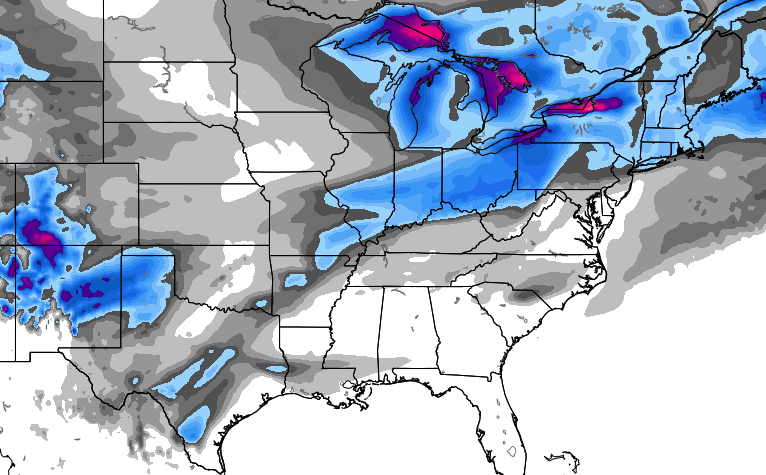
From there, the focus of the forecast is on a possible wintry mess from Sunday into early next week. The European Model shows the areas with the best chance for frozen precipitation through Tuesday…
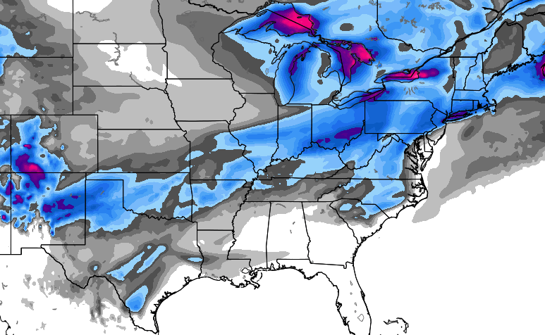
The model then forecasts another system to follow that one up Wednesday into Thursday and that one has colder air to work with. You can see the additional trouble spots showing up after Tuesday…
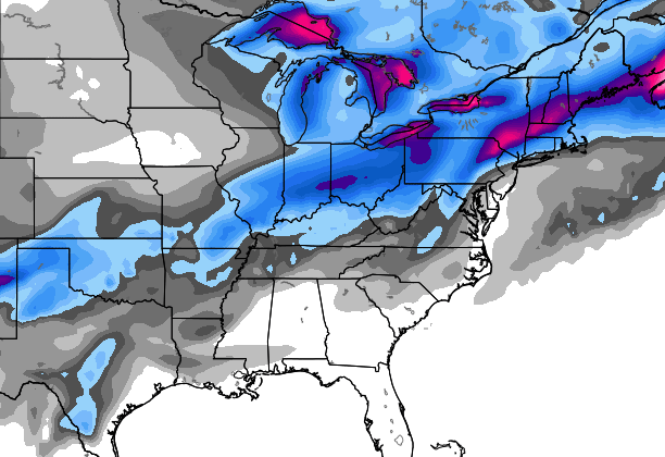
That seems to match up very well with new run of the European Ensembles control run…
 We have lots of time to figure out that messy possibility and that’s what we will do over the next few days.
Have a great evening and take care.

false returns on the radar and false returns with the models.
thanks Chris for what you do.
I do like the in- creasing chances
four some measurable snow next week
Not really, it more like increasing chances for ice! With backside flurries as system departs and more bitter cold with bare ground.
This.
Rain with backside dry air and below 32 temps
This.
The maps include any type of frozen precip, so basically a lot of that could be sleet. I at least want a good snow, doesn’t have to be dome buster but at least like 5 inches or more though I will gladly accept more. I am likely going to move to Bowling Green from Lexington this upcoming fall so my chances for big snow will DRAMATICALLY decrease and I will be stuck with the So. KY weather. :'(
I’m a meteorology student at WKU in Bowling Green. The myth known as the Bowling Green bubble puts the Ky snow dome to shame.
Your a rookie. Don’t dis the dome. 😉
That’s cool. I am going to attend WKU (most likely) and study for a meteorology degree. That’s why I’ll likely move there (unless plans change)
Just last March (2014) was an exception to the so-called Bowling Green bubble. About four inches of snow/sleet/ice fell. For a few days after, Bowling Green was unusual in having one of the coldest temperatures in the state as the snow cover hanged tough while the rest of the state had no snow cover.
Then welcome to the Hill Israel! And TennMark, the day the dome fell was one heck of a great day.
I’m a WKU graduate, attended Western during the 2000’s. I only recall a few ankle biter snows in Bowling Green, along with a few relatively minor ice storms. But I sure remember during my senior year the so-called Super Tuesday tornado outbreak of February 2008 inwhich areas near Scottsville KY, Central City KY and Tennessee were devastated by EF3s/EF4s.
http://en.wikipedia.org/wiki/2008_Super_Tuesday_tornado_outbreak
My wife grew up in Bowling Green, and she experienced a few big snows during the 1990s, and endured a really bad ice storm in 1994.
BTW, the only weather courses I have taken are NWS Storm Spotter courses, never took any WKU meteorology c*l*a*s*s*e*s.
@Israel, you really know your stuff. Have you considered a career in meteorology? 🙂
That was supposed to be a smiley face. Not a sarcastic face. Sorry.
I am going to study meteorology this fall, that’s why I say I’m likely going to live in BG. I would love to work at a NWS office being a forecaster, that is my goal.
Good for you, Israel! 🙂 While at WKU, I only took enough natural science for gen-ed requirements. I now wish I had taken meteorology (took biology and geology instead). Barely survived biology as I was then a brand new freshman and my bio professor turned out to be a dud; he was perhaps marking time to retirement. But my geology prof was one of the best teachers I ever had going back to Kindergarten; enough so that I eventually abandoned my young-earth creationist/world Flood views I grew up with. I would recommend him to you, but he has also retired 🙁 .
Good luck! I’m sure you will excel.
26 degrees and rising
Yeah, I looked on Mesonet and saw Madison is sitting at 26 degrees at 9 PM and the temp has been rising, rising, rising. Area WKYT forecast high today was 17 with a low of 16.
Anyone catch a mention of what’s going on? I don’t see anything mentioned here on the blog about sudden warming.
Southerly winds before the front comes through tomorrow
The cold air and moisture seem to still dislike each other in the KY area!
Whats else is new right!
This too.
Temp has rose in Carrie bout 5 degrees since sun went down setting at 26 right now
I guess we can all look forward to the 5 inch snow in march that melts the same day 🙁
Once again the models go North and the can gets kicked down the road LOL 🙂
I was thinking it would be realistic to think that we might get 4 inches total this winter in Central Ky, a quarter inch at a time, but now I don’t even think that’s going to happen.
A 1/4 inch snow fall would be a huge addition to our 0 inch total so far.
Exactly
if it stays persistently below normal temperature wise.
it is eventually going to snow someday
if it takes a Clipper to do it well d$?#’t, it will take a Clipper.
30 here in Carrie of knott co. Gonna go above freezing over night looks like
Why is it all north of here?
Got any thoughts on spring yet Chris? Like hopefully it arriving early for example?
I couldn’t agree more.
So depressing to look at Southern states and see snow predictions.
I also wish I lived back up in Nky.
Again, my hair is messy, weather to me looks rainy for richmond.
Climate Prediction Center going projects warm air the last half of the month.Hopefully that’s wrong. Still have in getting snow at some point. It wasn’t that long ago that Louisville got a double digit snow in early March.
No snow for you!!! So the SNOW natzi will win again. Snow for southern Indiana and cold rain for all south of the river. I call BS!!!
Really starting to be concerned that moderate temps (average) will return past 10 days out based on the CPC runs along with wintery mix possibilities.
Very strange winter as almost all mets pointed to a very harsh winter based on warmer sea surface temps in the gulf of Alaska, high early season snow coverage near the pole to name a few, all of which was going to create blocking/-AO/-NAO and positive PNA. Except for the current short lived brutal dry blast we look to head back to marginal events pushed by a fast pacific split flow with little or no blocking.
With the AO and NAO being positive this winter it will be difficult to get enough sustained cold to keep us all snow. With no blocking the fast flow does not allow low pressure to slow and dig to our south. It looks like it will need to be a thread the needle storm to put snow down over the next week.
On a positive note the MJO looks to go into cold/stormy phases (7 and 8) later in Jan for a couple weeks and may be are only shot for sustained winter weather. Hope something delivers in the next 6 weeks.
Pretty crazy temps tonight. Just stepped out for a bit and it felt so warm.. Funny how 33 feels warm when it was below zero this morning.