Good evening, gang. I didn’t have the chance to update this afternoon and I have a short window to update things this evening. Life gets busy sometimes. 🙂
The system moving in later Sunday into Monday continues to look to bring a wintry mess to our region. The GFS shows the potential I’m talking about…
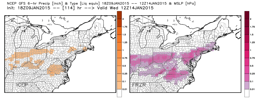
The map on the left shows the sleet potential with the one on the right showing the freezing rain areas. The bulk of that would fall late Sunday into Sunday night. Monday may start with more in the form of plain rain with colder air coming in as the day goes by with another mix of light snow taking over late day into Monday evening.
Told ya it was looking messy.
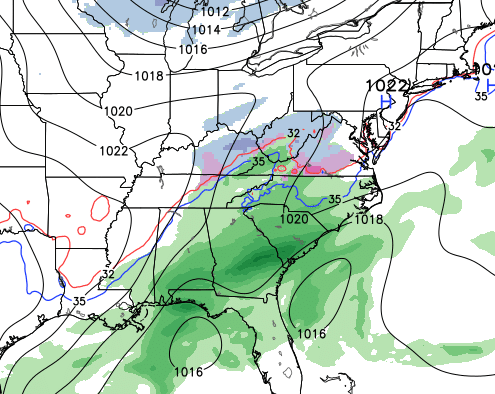
The next system later Wednesday and Thursday is giving the models fits. Some runs show up with a strong system, others show up with something weaker. The high resolution GFS shows one of the reasons for the issues as it tries to figure out which southern low to focus on…
 Still plenty of time to see how that comes together. I will have a full update later tonight. Enjoy the evening and take care.

This winter has been so frustrating. Cold and dry or wet cold rain. Lousy winter so far. If this is going to be our winter. Bring spring on!
I know the forecast for Somerset. Cold followed by warmup to a brief mix to rain to moderate or heavy rain to snow/rain mix to a little snow sleet left over and colder again. By the way Chris, I really enjoy the site and not negative towards you at all. It’s just a pattern that we currently are in that has not been broken here, I’ll have to see significant snow here before I believe it. No ice please.
with no disrespect to chris ot any one else but i do believe a lot of mets are going to bust on the winter weather forecast for this area……we are way below normal for snow fall in eastern ky. and western wva. and except for the cold november…..which was still in the fall……we haven’t had a whole lot of cold except for this past 2 to 3 days…..days are getting longer especially into feb. and cold and snow usually don’t sustain it self from feb. on…..just saying.
Only takes one storm some of our biggest snowstorms have come in February and early March.
Agree!
How many of those years recorded *literally* no measurable snowfall up to that point?
Enjoy the winter weather this week. We should finally start to see some of the white stuff.
Thanks so much for the update, Chris! Looking messy for sure!!!
Please someone do a snow dance for Somerset!
Still now snow….wa wa wa 🙁
I think I asked for some ice not to long ago …..too bad that don’t work when I ask for snow .. 🙂
Bryant – Jeff Hamlin – Prelude……any thoughts…..LMAO….
You guys need to get a room. It is just weather we are talking about. Hell I still think the Ohio River is going to freeze over this winter. Sure not a blowtorch in my books.
Late January to mid Feb. generally is our coldest days of the year and March has brought many of deep snows, just don’t last as long. So there is plenty of time to get an old skool, dome bustin, fence breaking, trend stopping snow storm that are is not a ankle biting, salt crusting, cold rain running by the 33/32 rule. We just all need to THINK SNOW!!!!! Oh yeah. Thanks for the update Chris.
The only room I want is one where I can light up a cigar and have a few drinks. 🙂
Jeff, you need a blowtorch to light that cigar?
A small triple flame torch (which I have), matches or a cedar spill do great. 🙂
So it will now be a triple flame torch kind of winter.
What in God’s name is a cedar spill? Where I’m from out here in younder KY im familiar with the matches, a bic, and a zippo with Dale Earnhardts number 3 on the zippo.
A cedar spill is a small piece of cedar. Check out this video: http://www.youtube.com/watch?v=Cdr6_T9R5u4
That’s kind of nifty learn something new everyday.
It actually makes a difference in the taste of a premium stogie.
The jury rest for now your honor. lol
u guys are funny …keeps the blog entertaining
Yes they do. That is why in had to instigate things from the last post.
Bj must have stayed at a Holiday Inn Express 🙂
Despite favorable factors like the SST’s in the Pacific, it amazing how uninteresting the weather has been this winter. Finally, it has turned cold, but the lack of storms has been disappointing.