Good Saturday, folks. It’s another frigid day in the bluegrass state… yada, yada, yada. We’re 10 days into January and temps are running WAY below normal, so far. Over the next week, thermometers won’t be as cold as this past week, but will still run plenty cold enough.
The trade off for a more normal brand of cold is a pattern that looks pretty messy. That all gets started late Sunday as moisture returns from the southwest. With temperatures in the low and middle 30s and a frozen ground, things could get a little dicey for some areas.
The mix and rain will then carry us into Sunday night and early Monday. The GFS continues to spit out some pockets of sleet and freezing rain…
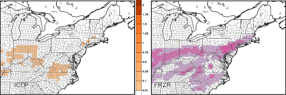
Even with temps just above freezing, we have to watch the road temperatures. The ground is frozen solid and will be as precipitation moves in and that could create some icy spots. Something to watch out for!
Colder air funnels in by the end of the day and that sets the stage for a touch of light snow taking shape Monday night…
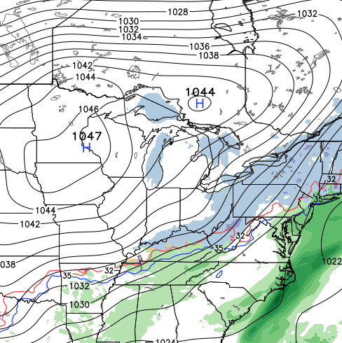
That’s a pretty strong high building in across the Midwest for the middle of the week and that keeps our temps running on the seasonally cold side.
The next system then tries to develop under that high by Wednesday and Thursday…
I will update all this later today. Enjoy your Saturday and take care.

As someone already stated, it is amazing how there has been a lack of storms this winter. Not just for out part, but for the entire US. I’ve noticed the southern jet is actually getting involved this winter, just not as much as everyone had thought, and not as many storms or cold for it to play around with. As we enter mid January, we are basically half way through winter and we still have a lot of time left. But to reach all these winter forecasts from different outlets, we are gonna have to have a very harsh last half of winter ahead of us. And I, nor does anyone else see that.
Yea – the past decade plus, we’ve never really hit the snow lottery, but no one seems to be hitting it this winter except for places like Buffalo.
It is definitely the dullest Winter I can remember. Not just for here but like you said nationwide. It will be interesting to see just how many places set records for lowest snow amounts for a season. There’s still time and all it takes is one decent event. How can we expect anything here when the usual places can’t get any snow. I’m glad we don’t have to rely on snowpack melt for water here, it would be a disaster.
Too much model reading, cold air is harder to move at low levels
Chris you said it best! Yada yada yada…..do we need to say anything else about Kentucky weather….
Thanks Chris. Hopefully one of these things will finally spit out some snow . We’ll see. Have a great Saturday everyone. I gotta go to work!
With the lack of storms mentioned above, and noted nationwide, it could be a year of drought across much of the country, unless stronger low pressures begin to take shape. Most of the storm systems so far have been wimpy, wimpy, wimpy. Winter and spring is when most of the U.S. receives widespread rain, but it’s not happening this year. Another reason for concern is CB’s comment a few posts back that this summer would not be as cool as the previous two were. We really need to see some super soakers spring up before summer.
If we can go all winter without snow, I wonder if we can go all summer without rain? One is unpleasant, the other is purely sadistic.
Thanks so much Chris. Cold out feeding the critters today.
We got some cold just need the snow. Keep the faith.
Have a great day y’all. Go Cats!
So will February bring any snow or is it going to mild? We had a cold November and milder December … Now we have had a cold January soooo
I know accuweather isn’t very accurate but in their extended forecast temps only show 40 like 2 out of the first 22 days. And I’m looking at seky. Once again I know they suck but just to compare they had/have almost all of jan in the mid to upper 40s and even 50s. I’m hoping feb will be the month we get all the snow!
I’ve followed the blog for a lot of years and cannot remember CB being this unenthusiastic about snow chances in his posts. If we hit mid February with nothing, I’m hoping for a early spring. Since there has been a severe weather drought for the past few years, maybe we can track some fireworks this spring.
I really can’t remember a winter that we have gotten this far into without at least a threat for some winter weather. We have not even had one of our famous 33 degree rain events. Nothing really stands out in the near future to give us much of a shot of accumulating snows either. The forecasts for next week are basically the same as last decade in that it’s just going to warm up and rain when the precipitation gets here. Looks as though we are going to get into at least mid to late January with nothing to get excited back.
A few outlets are predicting it to turn rather mild after next week. If that comes true, then you can write January off for winter weather. February may be the month that we get our snow. I say let’s get it all over with in February and move on to warmer weather in March.
Not giving up on winter yet..It’s been dull but believe thing’s will start to turn around the last week to 10 days in Jan..Modeling is suggesting the AO may finally go back to negative territory after 10 days..Right on cue higher than normal height’s at the arctic are showing up in this time frame…(Thank you -AO)…..Also the NAO is modeled to maybe go neutral…(Good thing,Slow down the flow,Bigger low’s )….All this with a +PNA and thing’s could finally start to get interesting..From what i have read weak El Nino’s arrive late in winter also..Now will all this materialize.Who know’s but we shall see..Think snow…
I wish I could nonchalantly throw around your words as if I knew exactly what you were talking about. LOL! 🙂
I love the way you think Ready4snow.
Rodger says thanks Mr Bailey for all you do but warming up from zero to rain is VERY depressing. Bring on spring and Daisy Duke weather if this is our sad winter. Rodger in Dodger!
I fully agree, Roger that.
I can’t decide if this winter, so far, is more similar to 1989 or 1999. Neither one of them were very good in terms of snowfall. But 1999 came on the heels of “that one.”
The 12z nam trending warmer and warmer for tomorrow’s event. Very disrespectful looks like another cold rain.
*makes grumpy cat face* Good.
No amount of wishing and hoping for early spring will make it happen.
True, just like wishing and hoping for snow wont make that happen either. So I have my fingers crossed for nice sunny 50 something days for the rest of this miserable winter since the snows obviously aren’t going to come to fruition.
As if it weren’t depressing enough. After 2 degree low and a 25 degree high today. We get 40’s and rain tomorrow. From a storm that has snow on the radar today in Texas. That is just cruel joke.
Very true Jimbo. Anyone that would say that the climate has not shifted (whether it be totally by nature or with the help of mankind) is totally full of BS!
We’re just in a 25 year long stretch of no big snows. Oops, did I let the secret out? lol.
Got into the 30s in seky today not bad for a day that was suppose to be in mid 20s
Almost nice enough for me to go outside and have a cigar! 🙂
Great day. Cats 15-0 by a whisker
Warmer weather would be nice. Sure beats rain and 40
Oh well, at least the Cats won and Loserville lost. I know that puts a smile on Bailey’s face, he hates everything about Loserville, just like the rest of us
Seriously…..Loserville. This is a weather blog. More than enough tolerance in this State for all schools! Gutty win UK, tough loss UL. Think snow.
Connor if college sports smack talk offends you, then lol at ya. :p
wow……..mature.
First it was Global Warming, then Climate Change now I feel Global Climate Stagnation is on its way…
Freezing rain advisory posted for NKY counties and WWA for Southwestern Ohio/SE Indiana.
Let’s just see how this plays out!