Good evening, gang. Another cold day is in the books with a few spots going below zero once again. Now we begin to focus on the increasing potential for messy weather in the coming days.
Let the headlines break it down…
– The first thing to focus on is the frozen ground and road temperatures that are below freezing. That’s not something that shows up on computer models, it’s just something you have to think about. Why is that important?
– Moisture moves in later Sunday as temps head above freezing for the first time in nearly a week. That moisture will be falling onto a surface that is frozen and that increases the potential for, at least, some local icy problems. I have seen several cases of that happening with temps several degrees above freezing.
– Our mix and light rain will continue into Sunday night and Monday morning when mainly rain takes over across the entire region. That won’t last long as colder air dives in from northwest to southeast by Monday evening.
– Another mix of light freezing rain, sleet and snow will then be possible across central and eastern Kentucky into Tuesday. Temps during this time will be below freezing during this time and some travel issues will be possible.
The GFS precipitation type forecast continues to show areas of sleet and freezing rain through Tuesday…
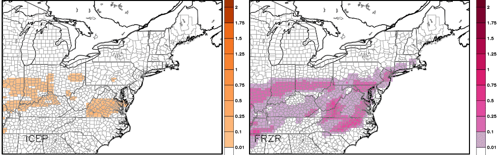
It only takes a small amount of freezing rain to cause some issues and that’s something we will have to closely follow in the coming days.
I will have a full update later tonight. Have a great evening and take care.

Been above freezing in seky last 2 days
So you’re telling me that after 19 years of no birthday snow, there’s a chance of seeing some Tuesday? Intitialy I wanted accumulation, but I’d be happy just to see flakes to celebrate 20 years.
Happy Birthday young man!
We always appreciate your input here.
Have many more birthdays! Anytime you get good snow in Bowling Green, you can celebrate by sleighing down the hill in front of Van Meter, or even down Reservoir Hill 😉 .
Ah i miss my irresponsible days of youth at WKU.
Thanks guys. I don’t always put in comments because I’m not an expert with a degree yet, but I often try my hand in forecasting and come here to see if I’m on the right track.
And TennMark, I was blessed to experience sledding down the hills of WKU during the March 2014 winter storm. Talk about good times!
Even though I’ve become more of a warm weather person as I have gotten older, still disappointed I only sleighed once at WKU (down Van Meter) before I graduated. Used a big piece of cardboard.
Vandy students and other hearty souls sleigh down the huge hill from the state capitol building in Nashville, although definitely at their own risk 😉 .
Thanks for sharing, when I go to WKU, I might do just that!
I guess for those of us that actually DID get above freezing the past couple days freezing rain won’t be as much of an issue.
Second day in a row with temps in the area higher than forecast.
Friday it was 7 to 10 degrees warmer. Today, 5 to 7 degrees warmer.
Not really sure what’s happening with that. Odd, really.
Based on the weather CB is calling for on Monday evening, it looks like Mother Nature is indicating her displeasure of Ohio State winning the game. Seriously, what a fitting combination of weather and possible outcome. Blech.
On the positive side, winning the first college football Div I playoff will create a lot of valuable memorabilia for the Ohio State players to autograph and sell. 😉
Tattoo shops especially. 😉
This will likely be the winter of 33/32…… Boo!
That might just be a top 10 comment!!!!
I like your sense of sarcasm. 🙂
This.
It was near freezing yesterday here. Much warmer than forecast. Today was close to forecasts with only a couple degrees higher and below freezing still.
Now it is just a case of how tomorrow plays out. Forecasts calling for 45 for the high. Wonder if it gets there. And lows in the mid 30’s. If the high comes in lower and we can drop a few degrees with the low that might set the stage for a big mess. Hope my area can hit that high and the overnight stays warmer since farther east. And hopefully Monday is the 40 they are calling for as well. Would hate to see a miss Sunday on the low side and then at freezing overnight into Monday.
In any case seems that the cold rain will be the better option. Thanks for the update Chris.
my comments are getting lost in space
Our weather is lost in space!
The auto-mod can be overkill at times. Even words like c*l*a*s*s and D*i*c*k*s*o*n County, Tennessee will cause the entire post to be deleted.
Thus, one either has to use new words or insert the equivalent of a ” * ” between the letters.
you’re right, I change m@a@s@s with air.
I would like to receive emails dailey with your updates on the weather
Still think warm air wins out and advisories are to far south. Seen this set up to many times for it not to be different. All rain for river counties south. Might be a slight period of freezing rain, but temps warm quickly combat it. Goinf to be interesting to say the least.
Thanks for the update Chris. Cats escaped again and the Cards blew another big lead and could not win this time. They might learn one of these games to put a team away.
Cards need to get a bench that can actually score.
I agree. They will come around.
Sounds like no snow again for southern Kentucky, will we get more than a trace this winter?
All rain tomorrow and Monday. Nothing frozen except near Cincinnati. When and if cold air arrives precipitation will be gone. Same song and dance only thing changes is the date.
The more things change the more they stay the same.
Yesterday, someone mentioned a Blizzard. If the temps tomorrow go above 40, I’m going to go get one at DQ. That sounds really good to me.
Now that IS a top ten comment!
Delish!
I agree great comment.
Good win by the Cats today. My bad towards the Cards fans with my earlier comments.
This week looks pretty boring. Actually looks like a typical week from this previous December-gray, rainy and sort of depressing.
Don’t know about you guys but I’m ready for March madness, Derby, grilling out and early summer storms.
Cats were close to same result. Cal did say they needed close games 😉 🙂
Your comments were harmless IMO.
my goodness what is going on with the weather? this is not normal to have such snow droughts everywhere is it el nino? started so promising in november
when will the Clipper train be arriving in my neighborhood.
if it can’t snow with this artic air hovering over us when will it.
I am amazed that it ever snows when a storm comes from the southwest.
I am on the phone with Alberta requesting arrival date.
Thanks, CB. Glad only ‘nuisance’ amounts of sleet/FR are expected. Might pose some travel problems but shouldn’t lead to power outages or downed trees. That said, I’m still hoping for rain and 33. 🙂