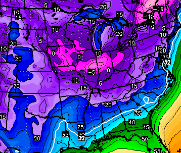
Good Sunday, everyone. Our bitterly cold setup is about to turn into a messy one as wintry precipitation and rain moves our way. I’ve been setting the stage for this for the past week and there isn’t a whole lot more to add to what happens over the next few days.
Precipitation slowly increases from southwest to northeast today. This could start out with a mix of precipitation and rain falling on a frozen ground. That could mean some icy spots developing and that’s something we are going to have to watch for. Here’s what you need to track the action…


Many areas could change to plain old rain tonight into Monday morning before colder air comes back in late in the day. That sets the stage for another round of light freezing rain, sleet and snow into Tuesday. Temps during this time will stay below freezing so we will have to watch for some slick spots in central and eastern Kentucky.
The air from Tuesday through Thursday continues to come in colder and it’s a period that likely keeps us with highs from the upper 20s to low 30s. The Canadian says a very cold night or two is possible…
While the cold continues to show up, the other possible system for later in the week does not.
If you’re looking farther down the road… temps relax some next weekend but the cold stuff returns quickly the following week. At some point… it has to snow…. I mean really snow… right? 😉
I will update things later today. Have a good one and take care.

What is the least snowiest winter on record? Are we flirting with that? It sure would be nice if it would snow while it is cold enough to stick around a bit instead of a late season snow followed by spring sunshine. Although at this point I am looking forward to cold roads and 35 degree rain, so a March snow would be welcome.
CB, I have a question about the analog year talk from last fall. What accounts for the meager winter weather this year in the context of the 76/77 winters? I suppose it is clear that a warming ocean and planet effect local weather, but I was just wondering if anything else stands out in the comparisons.
My father always told me we don’t have winters like we used to because we don’t test nuclear weapons like we used to. Just something to think about…
That’s could be a fascinating freakanomics type of thing.
You do realize winter started 3 weeks ago!??
So it’s about over then right?
As we know, officially, winter starts on the 21st of December but in the meteorological since it starts on December 1st so we are actually about half way through……With no snow.
We are also looking at not getting any snow for at least another week which will put us past the half way point of January. Any way you look at it, winter has been a dud this year.
I have to say I remember winters in HS where we had not snow up until the middle or later in January. It was even warmer than average at times. I would always think we were going to get out on time this year since I liked to travel to Ohio and Tennessee for fishing trips in May especially. Then we ended up missing 8-10 days or more with some decent snows and had to make up those days and would get out at the beginning of June. The year I graduated the date was June 6th.
I think the issue for some is that it is not happening now. And IF it does in late February or March we are usually ready for spring by then so it is not as exciting. And those tend to melt off faster.
Yes it did,but meteorological winter started 1 month before that. So we only have about 6 more weeks or so of time left(normally)
Wow. Helpful and kind. Thanks for the thoughtful responses. A person can’t start a conversation for all the policing that happens on this blog.
Western Ky already have risen to 32 degrees. That’s baffling to me that the artic air is getting flexed on by the good ol SW flow. That being said why is it as of late that a SW flow has no problems overcoming the cold dense artic air that suppose to be somewhat trapped at the surface?
Exactly. I am curious about the same thing.
Forecast low was 17, Madison Mesonet hit 10 last night. Continuing weirdness for third day in a row. Forecasts in regard to Madison or the weather station need some recalibration.
As much as I wish for it, no, it doesn’t actually *have* to really snow at some point. As long as
Always interesting when people choose to reference the “start” of winter.
Active snow pattern? “It’s been a hell of a winter so far!”
Meteorological winter (Dec-Jan-Feb)
Dearth of snow? “OMG you guys, it’s only just the start of winter!”
Winter Solstice (Dec 21-22 ~ March 21-22).
I’m going with a scenario that the Patriots triumph means the gods are pleased and will spare us the ice.
Btw CB, loved that retweeted joke about “join us against Missouri for our 3 OT game!”.
In the world of “has that ever happened before,” can anyone else think of UK playing in a season with two straight overtime games and have remained undefeated at the same time?
Have we ever gone a full winter withiout a measurable snow before?
Thank you Chris.
For the winter season to date, Lexington has recorded 1.6 inches of snow. Normal to date is 4.0 inches. Last winter, Lexington had 3.6 inches to date.
The lowest total ever for a winter was 2.1 inches in 1931-1932.
Richmond has had 0.1. Seriously.
Thanks Chris Mercer. Always like your number crunching to put things in perspective.
It’s a cold 30 degrees out right now. Maybe the moisture in the air?
Thanks for the info. We are actually pushing that record a bit. I doubt zero snow happens from here on out though.
Cold here in Lewis Co. got down to 7, but forecast was for 17. Ky Mesonet had us at 13 at 7am. Seems like a huge batch of cold air hanging over Eastern KY. Is anyone else experiencing the same conditions and what are your feelings on today’s warm up? Maybe a watch and see storm if temperatures don’t increase as they are calling for this afternoon.
I’d put carrie in knott county at trace for the year
Just have a really bad feeling we aren’t going to get any significant snow this year. This is not based on any scientific reasoning. Just a gut feeling.
Really stinks to see all that green on the radar below us and all the cold air around us eroding away. I have heard that cold air is dense and hard to move out, but i can’t remember a time that the cold has ever really won out. Thanks for the update CB.
Go Cowboys!
THINK COLD RAIN!!,
It’s a beautiful sunny morning here in the south Ern part of the state. Enjoying it before the winter storm (rain) moves in.
Interesting how their were several active hurricane years and now several years have gone by with each year being predicted to be above average in terms of named hurricanes and none have hit the US. Will probably be 2015! Go figure!!
We are not even getting the promising “week away” storms right now. I can’t ever remember going this far into winter without even getting a missed storm. I’m actually looking forward to warm up coming next weekend. The cold and no snow needs to move on out and let us get out and enjoy the outdoors a few days.
Into the 40s in knott co before noon.
33 here so far. To the south and south east of here counties are already showing low to mid 40s at noon. Would not be surprised to see us hit the mid-40s here. Seems like it is actually going to be as warm or warmer than forecast here.
And the fact that Bailey said the cold continues to show up but the storm does not is no surprise this year. I would say that at some point the storm hits with the cold but I have a feeling it will be right when everyone is really looking to spring.
40 in Louisville temps will fall as rain falls evaporational cooling kicks in. However the temps will not fall below the freezing making this a all out cold rain event, again. Sounds fantastic doesn’t it??? Wasted artic air that gets destroyed by the SW flow. Pointless!!!
Currently headed home from Indianapolis. Temperature is already 36°. Freezing rain looks to be a moot point even this far north! Roads are treated though!
Sleeting in Irvine!
sleeting and london and 43 degrees. What is wrong with this picture?
*in London
Goodbye cold air! Hello warmer than expected air. Will we ever get a decent snow? Cold without snow is a joke!!
Now that the latest wasted cold snap is ending and there isn’t even a prediction of a week away storm to break everyone’s hearts. I am going to take a break from the blog early this year. I have followed the blog for 5 years and have never seen it more frustrated/ depressed, myself included. The blog this year is more like Old Man Winter’s funeral. Chris has the best weather blog, he just hasn’t had anything to work with this year. I hope we get some snow this season, but I am not gonna hold my breath.
D-Day: “Let it go, Winter’s over man, Bailey dropped the big one.”
Bluto: “What? Over? Did you say, over? Nothing is over until we decide it is! Was it over when Frank Faulkner bombed Pearl Harbor?”
so much for the arctic air not being bullied ….wow…never under estimate the sw flow no matter how much arctic air is around
It’s actually time to face the hard truth, winter is, and will never be the same due to climate change. We could go on forever whether it’s man vs natural.
What I know is this: it’s been 17 years (1998) since we’ve had a clobbering from a storm. Yes we’ve had ice, ankle biters, and a handful of 5-6″ snows. But nothing like the storms of 1996 or 98.
Now I’m afraid we are accelerating into the next phase which is scant snowfall and infrequent arctic outbreaks.
Either way, this winter should have been mailed in by now.
Was out cutting some brush and ice began to fall. Had a few pieces go down the back of my coat and it was bouncing off everything. Temp actually dropped a degree so far. Setting at 37 at my place. Ground froze solid with some ice setting in places. Sure it will eventually warm to the forecasted temps for my area. Seems most outside a few places have already exceeded the temps predicted.
Supposed to be near freezing tonight. Can it actually get there? If so could be a messy morning if the ground stays cold enough. Doubtful I guess but will have to see.
Usually I just enjoy the seasons as they come. And I am actually into this winter from a standpoint of the way everything is working out from the standpoint of temps busting low for a decent period to a period of temps busting higher. Seems this is one odd winter. But outside of that the weather has been far from exciting. Not even models being shown for possible big winter storms even if they disappear.
Hope everyone has a great day and week ahead.