Good Wednesday, everybody. The cold has been winning a lot of battles since we flipped the calendar to 2015 and it looks like smart money is on that to continue. Not only is the cold showing up more and more, but some snow chances are sneaking back into the picture.
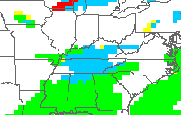
Those chances are out there this morning across parts of central and eastern Kentucky. This is some very light stuff that’s fairly scattered, but the bigger story is the freezing drizzle/rain. That is creating some slippery travel so use caution if you’re going to be out driving early today.
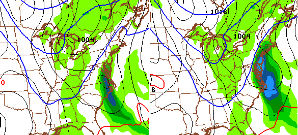
Another chance comes early Thursday as a southern system skirts by to our south. This was something the models showed several days ago and then lost it. Well, they are bringing it back to some extent. The future radar from the Hi Res NAM…
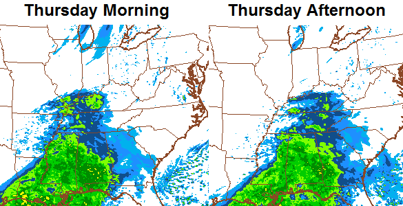
That could be a streak of some light snow and flurries spreading eastward across the state. That’s not too far away from showing something a little bigger, but most of the moisture is to our south. The GFS is also showing some light stuff…
A weak cold front follows that up Thursday night and keeps our Friday forecast colder than what I was thinking a few days ago. Some areas may not get out of the 30s, again.
Our ONE milder day looks to be Saturday with highs in the upper 40s to low 50s with very gusty winds. Those winds pick up Saturday night as a cold front dives in here from the northwest. Temps by Sunday drop through the 30s with gusty winds continuing. What about the snow chances? The GFS continues to like the snow shower idea, but is now developing low pressure just to our east…
The trend for next week is for colder air to continue to pour into the region via a couple of cold fronts. More on all that later today.
I leave you with your tracking tools of the day…


I-75 at MP 36
London

I-75 at MP 23
Corbin

I-75 MP 23
Whitley County
I will have updates later today. Have a good one and take care.

Interesting write up on the lack of snow at Lexington and Louisville for December and January and how it is actually very unusual. The only time Louisville had no measurable snow in December and January was 1931-1932 and it has never happened in Lexington.
http://www.crh.noaa.gov/images/lmk/SnowDrought2014_2015.pdf
Thanks for posting that.
When you look at it in a more realistic sense of “snow drought” being little, instead of absolute zero snow, there’s a ridiculous amount of Dec and Jan months for both Lex and Louisville that would fall in the Trace to 0.9″ range for the individual month.
In fact, looking at that chart is a stark reminder of how often we should expect that little no matter what the models may say.
Yeah I jokiningly said a lifetime yesterday. Since I was born in ’69 it has been a life time since this long of a snow drought. I like our chances moving into Feb., but not holding my breath.
What I noticed is that there are only 13 years since 1940 that had double digit snows in January for Lexington. 4 of those were in a 4 year period in the late 70’s. It just goes to show that the “big one” that everyone is so fond of is a rare event around here and that the late 70’s were such an exception.
Multiple accidents all over the area this morning due to black ice.
If the link that Chris posted doesn’t work for you see my post from last night where I copied those comments into this blog.
Everything still going as planned for the last week of Jan..West coast ridge, negative EPO and AO. Deep trough in the east…Don’t let the warmistas get you down..The “Big One’ coming to a town near you…Yes even Rolo is back to herding his goats..Stay tuned…
Welp, we have the cold air, but like the little old lady in the Wendy’s commercials from thirty years ago: Where’s the beef (snow)? Kind of like a big bun of cold air and no tasty burger (snow).
Not very filling.
Winter is about to deliver a 3/4 lb.Triple w/ Cheese with a side of Chilli..Ummm Ummm good..
That’s a big meal lol
I saw the news from the NWS a day or two ago about Lexington never being on record as having a trace or zero snow for December and January. Whether that stands or we pick up enough of a dusting to amount to a tenth of an inch or slightly more, what does that mean for spring and summer?
A few days ago CB teased a post mentioning analog years but I may have missed it. Did he ever post that? I would find that interesting given the very warm December, very cold January and very little snow for both.
He never said what year. 1991 has shown up on some of the long range analogs which was a bad snow year…maybe we can pull out a March 1993…another ho hum year until we got the big one.
He actually commented on one of the blogs a day or two ago that this winter reminded him of 92-93
absolutely zero trust in weather prediction technology – a week ago nobody said anything about snow for tomorrow/Thurs, then less than 48hrs before it, all of sudden it starts showing up and gets mentioned …. pretty sad with all the advances in computers that weather can’t be accurate more than 2 days out.
Waiting is the hardest part. (Tom petty)
No personal plugs on the blog!!!! 😉
There were some little bitty festive flakes near Lake Cumberland this morning. We are so snow starved, we will take anything we can get!
When are we going to get a much needed break from this stuff?I mean enough is enough.
There hasn’t really been any stuff
Baby powder on the ground in monticello! Time to get funky like a monkey !!!
Dusting in Mercer Co. this morning.
Lucked out here and nothing. School is on. I have heard from others that they had some ice, dusting of snow, and such. Made the roads a mess.
Seems the cold may have some staying power to some extent. Keep those higher temps down. We have plenty of time so maybe we can get a good snow. Maybe one of those everybody seems to want with the 12 to 20 inch range. Always a possibility. Everybody have a great day and stay safe.