Good afternoon, folks. It’s another cold day in the bluegrass state with some light snow and flurries falling. That’s a sign of things to come as the cold continues and snow chances keep showing up in greater frequency.
The next round of light snow and flurries will scoot eastward across the state tonight into Thursday. The best chance appears to be along and south of Interstate 64. Can some areas squeeze out some light accumulations?
Better weather pushes in later Friday into Saturday as another cold front sweeps in early Sunday. That front will usher in much colder air for Sunday and Monday. A band of rain showers will be ahead of the front with snow showers kicking in behind it…

The Canadian Model is on the same page as the GFS…
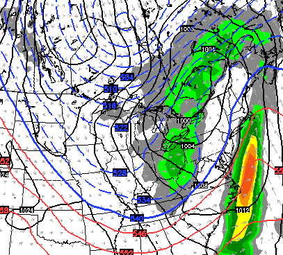
Some flakes could carry us into Monday morning on a gusty northwesterly wind.
The next system will dive in here on Tuesday and ushers in another shot of cold air and the potential for another round of snow showers and gusty winds.
The models continue to point toward a merging of the cold and a storm system coming from the southwest at some point later next week…
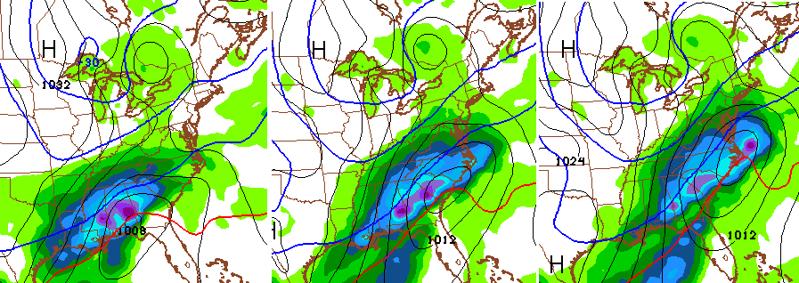
We will see how that works out, but the cold and the active southern jet have got to hook up at some point.
I will have another update later today. Take care.

I will take two of those last set of maps and a side of NW shift. It has got to happen sooner or later. Doesn’t it. Apps runner here we come.
Thanks for the update Chris.
THINK RAIN!
that will get you slightly warmer rain than you normally would get 😉
Dome does have it’s upsides when it comes to ice and severe storms. Not a single snowflake seen thus far in the neighborhood, though our roads aren’t icy either.
Which is fortunate due to the city only purchasing enough salt to cover main roads.
Hey, at least they were honest about something for a change and told the rest of us that it would be survival of the fittest.
If we ever do get ice or snow here, I already have some music from Rocky training montages ready to go in the car.
“At some point Later Next Week…”, we’re back in hopeful mode ! 🙂
Question for all, would you rather? Have it snow 20 inches the rest of this winter (heck I think we will be lucky to get 5) or UK go undefeated and win national championship this year?
I want the banner. I can find snow elsewhere.
you can find Championships elsewhere as well 😉
Not with any team I usually root for. I am like the cursed fan or something.
I buy a pool and we have had cold summers since. Bought snow tires this year and have not seen snow.
Let me know who you want to bet against and I will root for them. We could make a fortune.
I bought a 4×4 truck in 06 and have rarely had to use the 4×4
I hate UK so I would settle for no snow and them get beat in the second round of the tournament.
No soup for you!
Snow. Definitely not a UK championship.
Definitely no soup for you!
20 inch of snow and UofL wins national Championship.
Booyah!!!
Good to see the chances. All one can ask for outside of the actual event. Thanks for the update.
Any thoughts on the longer term pattern for the end of January / early February?
Noooooo don’t say this: “the cold and the active southern jet have got to hook up at some point.” It may jinx us!!
Hook up??? I hope they marry; IF it means snow! I’m totally illiterate when it comes to reading weather maps. Lol. I just want snow- and UK to win it all!!! ☺️❄️⛄️❄️⛄️❄️⛄️❄️⛄️
I’ve seen many of you, and even my self, come close to throwing in the towel on hope for snow this season. But a good friend named David Aldrich from a station I toured down in Knoxville put it best when he told me this.
“You don’t give up on your favorite sports team when they are losing in the first half. No matter how bad they’re losing, you always say that anything can happen in the second half. In the same light, Winter is not over in the first half, and anything can happen.”
I like the way our teleconnections are trending, and despite the blowtorch outlook many other outlets are showing, my rookie eyes see otherwise.
My point, the maps shown my Mr. Bailey may only be the beginning. The second half is near, and perhaps nature has saved the best for last.
Use reverse psychology, think COLD RAIN, cross your fingers, and hope that a wintry gift arrives in due time, but even if it doesn’t, you never gave up hope, you’re alive, you’re well, and that’s what matters.
hard to think reality lol just sayin 😉
a storm 7 days out ??? hmmm finally some sanity on the blog ,things are getting back to normal 🙂
I guess we shall see, at least there is a chance.
Hopefully Snow’s favorite Petty song is not:
Don’t Come Around Here No More 😉
Nature will run its course, relax people!!!
By the way I’ll take the cats winning no.9 and the snow!!!
bm….. Me too! When your asking, ask for it all!!!
You’re asking.
Ninth banner and a nine inch snow.
Or a five and a four…..
Ah, the models are up to it again. Let’s see what happens. Chances are we get lucky some day!