Good evening, friends. A streak of light snow and flurries will zip across the state late tonight into early Thursday and this could drop a small accumulation. The best chance of seeing this band of snow is across the southern half of the region…
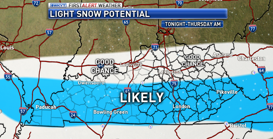 Again, that does not mean you’re going to see snow on your lawn tomorrow, but it does mean there’s a chance of a light accumulation for some. That may be just enough to cause some slick spots to develop on area roads.
Better weather rolls in for Friday and Saturday before another cold front arrives early Sunday. The European Model is back to showing a little more action with that…
 Colder winds will blow as temps drop throughout the day with snow showers taking over. Right now, I still don’t think that’s a huge deal, but we will keep watching it.
The cold keeps showing up and it’s showing up in a big, big way later next week and beyond. Here’s the European Ensembles 5 day running average of temps that start later next week…
That is a super cold look with a ton of blocking showing up across Alaska and northern Canada. It’s starting to take on a similar look to what we were seeing around this same time last year.
Enjoy the evening and take care.

I hope we get some clippers
that come along with the shots of cold air.
Thanks Chris! So what time would you expect the snow potential to begin. Being in London it looks like I have a pretty good chance of at least seeing a dusting?? At this point it would be nice just to see a white dusting. 🙂
Wishing it would begin soon!
Snow lovers be patient and Think Rain!
No mention of the mid weaker that was noted in the previous post. Ruh roh.
Weeker. Freudian slip on my part? 🙂
I would think the weak system tonight/am is getting more attention than something that may not happen next week
Thanks Chris. BubbaG, on the TV forecast, the mid weeker was in the forecast. I’m hoping to just see some snowflakes tomorrow that are big enough to see without a microscope!
It’s only been here for a couple weeks but I’m already tired of the cold. Bring on sun and warmth.
I hope all the school kids are doing the snow dance tonight!
This southern jet stream is being very wimpy so far this winter, we have had plenty of cold but the moisture has been a no show!
I havent said this in a loooonnnggggg time but….I smell snow in the air!!
accuweather is calling for a warm up for mid January.