Good Friday to one and all. We have snow showers and flurries flying around across parts of the region early today. This action will give way to a bigger potential lurking for Super Bowl Sunday into early Monday. How high that threat is where you live is the million dollar question. Buckle up and let’s get after it.
Snow showers this morning can cause some light accumulations that can create slick spots on area roads. This isn’t a widespread accumulating snow, but more of a local scale event since we are dealing with snow SHOWERS. You can get snow to coat one part of town with the other side of town seeing nothing… it’s one of those deals. I will have your tracking tools in a bit.
Let’s get into the late weekend potential. The model that showed the best consistency from yester morning to last night was the Canadian Model. It continues with the southern tracking low across the Tennessee Valley…
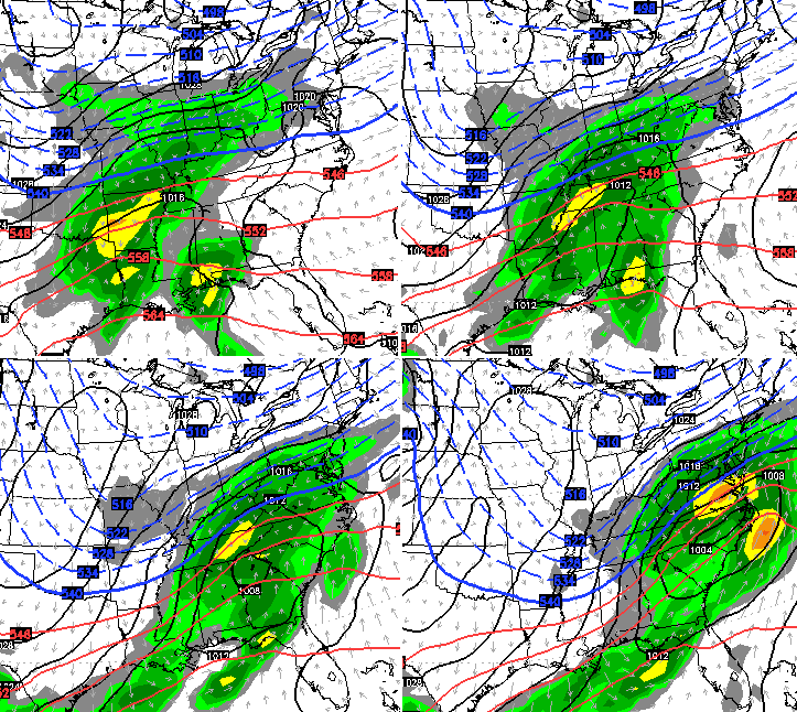
A track like that would put down a healthy swath of accumulating snow across the bluegrass state…
 Before you fall head over heels in love with our neighbor to the north, you should check out the GFS. The model continues to show a different solution with each and every run it spits out. The latest run is a little farther north with the low over Kentucky…

That setup would take the heaviest snows north of the Ohio River with rain changing to accumulating snow on the backside of the departing storm. Again… the GFS has shown every solution possible with this storm. That does not mean the above solution won’t work out, but give us some consistency!!
It’s really not like any of the models are a model of consistency. The European Model has jumped around just as much, but the latest run is close to what the GFS is showing…
 Let me repeat myself for the millionth time this week… don’t get caught up on the changes with each model run. Today will bring us to within 48 hours of the event and this is when we should start to see more consistency with each model. I suspect that may not come until the evening runs, but we shall see how things look with the 12z run.
It all boils down to this: If you want a big snow here in Kentucky, you want the low to stay on a southern track across Tennessee. If you don’t want a lot of snow, you want the low to move right on top of us. Which one of those wins out? That’s the question we will try to answer later today, but it is a very fine line the models are walking with either solution.
Personally, I would take somewhere in between. The snow lover in me would like some snow, but the “I don’t want to have to go to work on Super Bowl Sunday for the second year in a row” side of me hopes we don’t get a lot. Oh, the internal conflict!! 😉
I leave you with some toys to track our early day shot of snow showers…


Hamburg Area from WKYT Studio
Lexington

I-75 @ Winchester Road Lexington

US 60 @ US 127 Frankfort

US 127 @ Frankfort Frankfort

US 60 @ US 460
Frankfort

I-75 MP 127
Georgetown

I-64 MP 97
Winchester

Bluegrass Parkway Bardstown

Western Ky Parkway/I-65 Elizabethtown
I-65 MP 32

I-64 @ 3rd St. Exit
Louisville

Downtown Louisville @ 2nd & Broadway
Louisville

I-64 @ I-264
Louisville

I-264 @ Freedom Way
Near Louisville International Airport

I-75 at MP 36
London

I-75 at MP 23
Corbin

See you later today with updates. Take care.

One thing to note: I know most of us hate cold 33 degree rain…however, (at least for central KY) we haven’t even had much of a 33 degree cold rain this winter. Light showers that don’t amount to much here and there, but no really big rain storm.
The ground in Berea is at full saturation. You made brown footprints when walking in the snow when we received the 2″ of snow from the last Friday. Even after a day of being sorta-kinda-frozen, it’s back to to squish city the last two days.
high noon model runs
three models vs 1 model.
was Gary Cooper Canadian?
Not moving in the right direction needs to head about 50 to 100 miles south. A cold rain with flurries is miserable. Ready for sunshine and warm weather.
+1 BRING SPRING!
Not possible.
Paducah NWS going with NAM and GFS north shift but Louisville NWS not sure. A big cold rain and Patriots win will leave me angry!
A little bit of dry snow in the air, even though Berea is nowhere near anything on the radar.
Either the storm will overproduce or The Empire will be successful on Sunday. I can’t see both happening.
NOAA Louisville shifted its wintry mix precipitation area north even with their southern solution, and now they do not include any mention of accumulation south of Lexington in their maps. This leaves a lot of speculation.
I don’t want a whole of snow, because I have to be out driving in it. Is 3″ a reasonable request? 😛
If someone gets 3″ consider yourself lucky.
I like the Canadian, but we all know that is not how it will work out. Trends will win once again. By this time tomorrow many of us will be saying…….Meh!
Thanks for the update CB.
THINK REFRESH RAIN!
I know things could still change and we won’t know more until closer to Sunday but what do you think the chances are for Bowling Green to get any snow?
You gotta go with climatology and climatology states that this storm will be a primary rain event with backside snows.
where was “climatology” when this storm was hyped 5 days ago Jude Redfield?
And don’t forget thermal profiles
Darren is the man I was wondering if anyone would catch on lol Now what about the thermal profiles I wonder who said that???
This storm was not hyped. Chris does not do that.
He didn’t say Chris. Half the people on this blog have been hyping this for days.
Since Katy Perry is the Halftime show. She should sing ” The one that got away” and dedicate it to WV and KY. Because it looks like the wall/trend will continue.
“sing”
So folks loved the GFS yesterday and rationalized its awesomeness, but now that it is going north- not so much.
I think backs from shoveling might be saved by this one 😉
That’s what I am saying. When it shows a snow solution it is great, but when it shows rain well you know. I would guess our biggest snow of the season fell last weekend.
in Louisville it was Halloween at least at my house.
The GFS is the fair weathered blog friend (pun intended). If it looks great- GFS rocks! If it does not, GFS sucks!
Well, GFS badger don’t give a shoot.
Ain’t that the truth. Everyone worships the GFS for some reason especially when it says what people want, even though it consistently wrong
sticking to 6-10 inches 1 64 north, and 3-5 in SE/E KY on backside as storm slows down and throws moisture back at us.
I would say that is on the high side and likely more north for the main action.
Notice CB did not pull the trigger and put the “gun” back in his holster with potential and the bullet in shirt pocket like Barney Fife 😉 🙂
I’m afraid the bullet hasn’t been in the gun all winter & I’m keeping it in my pocket for this storm too…at least where Southern KY is concerned.
I’ll watch a real meteorologist and see what they say.
I’m changing my prediction from all rain below I-64 to all rain below the Ohio River.
Weather channel has Knott county pretty much all rain. I’ve seen it numerous times and the backside snow forecast never amounts to much here. Then the forecasters say” the cold air just never caught up with the moisture.”…….same old song and dance for this one as well. I say my area will be lucky to get an inch.
Still got two days to play with and the mean time this storm track there saying is meanless as weather it’s going north or south. besides the storm hasn’t even materlize yet.
The 00Z will be the tell all. If the models are still where there are right now, then yes, major disappointment.
Just remember, the main energy for these two storms is still not on land.
Until I see 4 straight runs of the same trend, no need to jump ship.
I think Darth Bubba is right. Sheriff Bailey has holstered his weapon and is calling in the dogs.
Oh well, at least blowtorch Bryant is gone. Man that guy was annoying.
Blowtorch less annoying than all of the “hurr durr bring on that thar spring!” people while we’re still sitting in Jan.
Why do we do this to ourselves YEAR after YEAR?? It’s excruciating!!!
For years I let it get to me. I’ve probably attempted to kick the football more than anybody. For whatever reason (hopefully because I’m getting older and wiser) I don’t worry about it anymore. I’m content to look out my window
Lucy = models
Grab your umbrellas. Even though this thing is not on land, trend is on the side of our neighbors to the north (like always). Something with the weather has changed the last 17 years where moisture and colder temps just cannot meet up in this area of the country. Areas on all sides of us have gotten bigger snows than 95 percent of Kentucky. I’ve got a child that is 16 that I think has not witnessed a snow bigger than 6 inches.
Knox Co. is going to safely make it into February without its first measurable snow of winter 2014-2015.
Bell, Knox and Whitley will make it til Spring without the first measurable snowfall…
I’m with the Canadian eh’. Any of you other hosers on board eh’?
It’s a beauty forecast, eh.
Looks like all the big dogs are going with a northern trend. Not our year, sports fans.
Bring on spring, because springtime Charlie said so!!
Noamount of wishing will make spring get here any sooner.
did you mean to say “Noah amount”? 😉
Agreed!
well im cancelling my forcast, after looking morning info over its a RAIN EVENT for 95 percent of state, ICE POSSIBLE ohio river counties. on backside maybe light snow.
I don’t see no freezing rain out of this
low going track right up ohio river.
Any word on the 12z models? I think the latest run was at 7:00 am EST.
Rolo. The voice of reason. Bring Spring. Not one measurable snow going into February. Hoping for warmer weather.
Warmer weather will get here when it wants to. Have some patience.
Bring Spring!
BRING ON SPRING!
Rolocoaster was opposite of that just a few hours ago. Is reason a relative thing? 😉 🙂
Wow, hilarious posts today!
Bring the Canadian love. Models, beer, bacon, Rush, Neil Young, SCTV….
Thanks Chris!
Maple syrup.
12z NAM no snow love for us the northern shift has taken over anyone surprised?
Just surprised that so many people were fooled yet again
Something about that run just looked off. Like the NAM may have had a few this morning. 12z GFS coming in now. Let’s see what it says.
The NAM had a few alright, a few laughs at our expense.
It’s going to be close. Don’t trust the GFS just yet. Give it a few more runs.
I remember the NAM. Charlie Sheen had it real rough! Winning!
one model run down
tWo to go
it sure does not look promising
If CB thought this had a chance he would be stoking the flames like yesterdays tweets.
True, true.
Agreed
Just came a mini blizzard in eastern Kentucky. Lol
Heck with it…bring on the warmth. Im ready to break out my new R1
That’s what Im talking about your speaking my language. Nice weather and motorcycles go hand and hand.
I hate cold rain too, but I am hoping that is what we get so you don’t miss the game. I would NOT want to work on Superbowl Sunday! Thanks for all you do. GO PATS!!!
I agree! Normally I root against the Pats, but the media dogged them so bad they are the Good guys for this game. Marshawn Lynch’s ‘prima donna’ attitude has solidified the Seahawks as the Bad guy for me 🙂 Winning!
What did the gfs show.
Same ol song and dance…rain rain rain
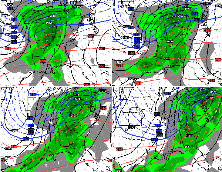
GFS a lot further south than NAM with low jumping from Arkansas to Paducah and then going east across the state. Did have some nice backside snow fall. This is going to be close. It the front is a little faster and/or the southern storm is a little slower then we are back in business.
Rolocoaster going back up in 3, 2, 1…. 😉 🙂
Okay. I pretty much saying the same thing. The low is sitting about the Shelbyville /etown
Seeing
I guess .we will be watching the 12 Z tonight.
another cliffhanger.
I hope that the euro is further south.
maybe it will be sniffing something else.
How do you think CB feels? Frustrating stuff!
I have a question. Why does all the new station always go with the Nam. Is it that that model is better within 3 days
Usually better within 36 hours…
But, this winter, the NAM has been useless more times than not. Not saying the others don’t have their flaws either.
Just think we wait this out until the 00Z runs overnight.
I hate myself for hoping for a few hours on this one. We had a decent (for us about an inch) little cover of snow in Huntington WV this morning but it didn’t survive past 11 am.
Thats right. A decent snow for us anymore is about an inch. If we get 3 inches, then thats about as much as we can hope for.
Everyone is writing this thing off way too soon based on the last 12 hours of model mayhem. The key is the arctic high pressure dropping south into the country. Yeah, I know the models are now ingesting better upper air data, yada, yada, yada. But the models have sucked horribly this winter, even right up until event time. Last Friday ring a bell?
Without that arctic high, no doubt this storm tracks farther north. But with the cold, dense air dropping south, don’t write this storm off as a rainstorm. I would wait until later tomorrow until jumping ship.
We have seen time and again. Artic air is no match for a southwest wind. Yesterday it was 33 degrees at my house at 11am by 2pm it was 50. We all need to face it. This area only gets Old Man Winter’s scraps. If I live to retire in the next 7 years, I am getting out of this area. Going far north or south, don’t want to leave any doubt either way. It is torture living here in the Winter. Sorry for the long rant, Mark
Guys, we are hoping for things that just won’t happen in our neck of the woods anymore. Bailey, hate to say it, but it’s time to move on and start looking forward to spring storm season.
Enjoy the rain folks, I’m gonna work some overtime this weekend, and start daydreaming about cycling, grilling out and warm weather.
This is the worst spot in the USA for winter weather!
I see nothing encouraging about the 12z GFS primarily all rain.
Sad. Just so sad. I’m at a loss for words.
Why not just wait until 36-48 hrs. to start talking about a winter storm for us. Heck, it is now showing to be in the next state and with little impact on us here in KY. What’s the point? Missed snow forecast in NYC recently cost the city over 200 million dollars. I know type of precip is tough to call in this area ( warm/cold transition) and is a challenge to forecasting. So, need to hold off on any early precip predictions in the winter, seems to me.