Good Saturday, folks. Our Ohio Valley winter storm is still on track and that track appears to be right on top of the bluegrass state. That’s a path that isn’t good news to snow lovers across our region. It doesn’t mean we won’t get some snow from this storm, it just means the big deal snows will likely fall to our north.
Some thoughts…
– Clouds will roll across the state today and we could see a touch of light snow and light rain develop from west to east this evening into tonight. That will be interesting to see how that leading band develops.
– Low pressure is likely to track right on top of us for Super Bowl Sunday. It is interesting to note, the Canadian Model did slip a little farther to the south from it’s earlier run…
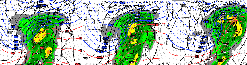
– Still, it looks like any overnight and Sunday morning mix would go quickly to all rain with gusty winds joining the mix during the day.
– As the low goes by, temps crash hard Sunday night with a period of snow likely into Monday morning. Temps may drop into the teens by then. After all that rain and some snow coming down… a quick ice up of roads will be very possible.
– Light snow would make the transition to snow showers on Monday as very cold temps and windy weather make for a nasty day.
That’s how things look right now… does that totally rule out the potential for this thing to come back to the south some? No, but the odds of that happening this late in the game are very small.
Looking down the road toward Wednesday and Thursday… the models give snow lovers another chance at disappointment…
The Canadian.
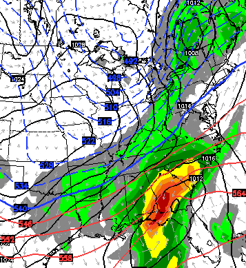
GFS
At least that storm is starting out on the Gulf Coast and would have plenty of room to trend northward. 😉
I will update things later today. Have a good one and take care.

“Chance to disappoint snow lovers…..” = quote of the year.
cli·ma·tol·o·gy:
/ˌklīməˈtäləjē/
noun: climatology
the scientific study of climate
Yea – that will probably be a moisture robbing low way down in south Georgia. LOL Way too far north or way too far south. GRRRRRRRR
*Sigh*
We need the low in the Caribbean a week out.
The system is even further north now. Lake cutter here we come.
cb, don’t bother with early modeling, they’re trash anyhow, and never verify.
What else is new? Oh well. Sounds like a good day to stay inside and watch the Super Bowl commericals.
If this were New York, there’d be an uproar and a half. But instead, it’s Kentucky. We don’t count.
I don’t see these two events even remotely comparable.
In terms of overall snowfall amounts? No. In terms of the buildup and the letdown…exactly the same. Except generally it’s happened at least 10 other times here in the past several years. In New York, who knows…
What buildup? CB said after each model run to temper expectations and not follow each run too closely until 48 hours out. That is exactly what he did. If you had buildup then you did it to yourself.
TRUTH
Agreed.
Yes, he did say to temper expectations. We also had people on here baiting others with “nothing to see here” comments before the northern jog. Take a look back at some of the older comments. Take a look back at all of the older posts, see some excited comments. You surely can’t sit behind your computer screen and tell me the excitement is gone. If that were the case, nobody posting today would be in such a foul mood–and I’m not the only one voicing discontent.
I agree Aaron. The blog fuels it’s own engine of either hype or negativity independent of any input from Chris.
Fine with me .. I have to work outside, driving, all day on Monday. The less snow the better.
Just watched the NWS weather briefing out of Chicago, and they said south if interstate 80, there could be a mix of rain holding down totals. I mean, this thing is apparently going WAY north…..Watch the next storm, it will stay south of us. LOL
Words I don’t want to hear, “looking down the road”…
“Nothing to see.” Well, plenty to see on models but nothing in reality.
Or 7 days away.
Does anyone ever ask why the early modeling is so consistently bad? If I were a weatherman and had to “nowcast” anything, I’d be demanding some new Math behind the models.
Basically the way I understand it is that,for us anyway, the energy that makes up the storms is not over land. Out in the pacific, the measurements are done via buoys that are few and far between. At Ten days or so, the energy is somewhere in Asia, and I’m not about to make any guesses as to the spacing of the mesonet in Rural Russia.
Edit: for use beyond three days out, the energy is not over land.
The way I see it, not getting a big snow tomorrow will be a GOOD thing. I am driving out to my girlfriend’s mom and stepdad’s house for the Super Bowl. Their place is on a back road in northern Madison County so I am glad to not have to navigate any frozen stuff. 😉
Now that’s the spin! Keep em’ comin’ 🙂
Hamlin, I think you need to give yourself more credit for driving in such conditions. Your vehicle looks like it was made specifically for winter driving, so I’m not sure what elsa you’d want to drive instead. 🙂
http://i.imgur.com/ctirbU3.png
Ouch. 😉
I’m hoping to upgrade eventually! 😛
Awesome! WinnING poSt of the day.
I live in Ohio & it’s going to be a all rain event with highs in the 40’s. Every big storm goes over top of the area it gets old.
Well Chris look at it this way… Looks like you won’t have to come in on Super Bowl Sunday! Have a great Saturday everyone!
I suggest CB stops mentioning events a week out and only brings events up two or three days out. The miss ratio for snow is easily over 95% and that is not exaggerating. If ice, go ahead and start talking a week out since those are sadly almost opposite in accuracy.
Maybe just mention events two days out…..
I second that
Or you could just not read it. You’re welcome!
I agree. Don’t mention till 2 days out. It’s so disappointing for a Snow lover to have it fall apart.
No sorrow here. Trends are trends I did not get excited and expected this to happen. Bring on spring I am now officially over this winter. Models can’t be trusted until the systems are in the states to be analyzed. At least I will only have to deal with rain falling heading home from the Smokies tomorrow afternoon.
Thanks for the update CB.
It has been interesting to see first central KY forecasts push the snow north then I saw Cincy say it last night and this morning Columbus is saying the same. Sounds like this low will move straight north!
BubbaG I feel your pain but CB can’t just talk about forecasts 2 days out but we could stop paying attention until 48 hours out. That’s my new approach. : )
Kind of same thing 😉 Maybe CB just calls them fantasycasts when beyond a few days out 😉
The models seems to create their own fantasy stories a week out as far as significant snow.
FreezAiromeo and Moisturette, star struck lovers kept apart by destiny, their families, “cli·ma·tol·o·gy”, lack of human sacrifice, or maybe they just can’t get their @#$% together.
The models are just a tool to forecast, but you need to look at the overall setup on what appears will impact the track of the next week storm. Two items that are different this time…1) we will likely have a neutral to -nao which would limit the adjustment north. 2) Will it phase early. My guess right now is the heavy snow will stay south unless the storm strengthens more. Like most I will not get excited until we get within 12 hours.
Que sera, sera.
Look at it this way. Looks like we’re all out of the snow and we won’t have the state divided by the have and have-not snowfalls.
At least we had last Friday’s snow. Might be our best of the year.
Go Cats!!!
Good thing public money isn’t spent on the models. The GAO would need to look into it. (Please add sarcasm if it is needed as I am not sure if public money is pent on them or not.)
We spend tax money on the NWS; and every winter, in my opinion, we waste half of our tax money. This year they didn’t issue any advisories for the storm that dumped up to 7″ of snow in some places; the rest of the winter has been a dud. I want my 53 cents back. 🙂
Four weeks left of meteorological winter. Time is running out for a dome buster. There is very little snow covering the United States right now, so we are not the only ones not seeing it. Although many mets predicted a big winter, it just doesn’t look like it’s going to happen. Hopefully after the winter is over someone will explain what caused this.
Good point. I was watching the US farm report this morning and they were focused on Oregon and the lack of significant snowpack. California is still hurting also.
Maybe Brian Collins can send us a “dusting” from Heaven!I really liked him, but he will always be remembered for that dusting forecast.
I guess Chris mentions potential weather events a week away because this is a weather blog and he posts every single day multiple times. Even those the “week away” snow events usually don’t happen, I guess he feels it’s something to post about. He’s not forecasting it, just showing us the models. It’s our own faults for getting our hopes up by reading what he posts.
That being said – with these crappy weather models, it’s almost like “what’s the point?”
My comment meant to have some winkies 😉 So the tone was off. Most of us get the week outlooks are pie in the sky and CBs thoughts. The problems is the models are creeping in further and still wrong. I have noticed this in the past few years and starting to stick out. This event and even to some extent the blizzard to end all blizzards are examples.
The models for snow are really-really starting to suck.
Yep, we were “in the game” for several days and then suddenly the rug was yanked out (almost overnight.)
I should come up with a list of analogies for how the models pull this off, there’s quite a few there for the taking.
I’m not one to usually say “let’s stick a fork in it,” but with February here, I think the winter of 14-15 has given us a lot of “potential,” with no follow through. The bitter cold never appeared with any staying power. The warm waters off of Alaska never delivered the results we saw last year. The record snow cover in Asia last October hasn’t influenced our weather patterns as expected. The AO/NAO never took a dive into deeply negative territory. And the weak El Nino has yet to deliver the increased storminess we usually see across the southern areas of the U.S. We have seen a few rainy systems come through, but nothing out of the ordinary. I mean–it is winter after all–it ALWAYS rains.
It seemed we had a “perfect” set-up for AT LEAST a decent winter, but it never delivered.
At the end of last year, I heard plenty of explanations from weather buffs on what drove the cold, despite the +AO/NAO. I hope someone explains why this winter turned out to be a dud.
Of course, we do have one full month of Winter left. But it would have to be EPIC for this Winter to be remembered as “decent” in our area of the world.
Given model chokes just a few days out- the trend truly is our friend as far as accuracy.
Good question..Just goes to show apparently there are other things at play before anyone can nail down a long term forecast in winter..Mother nature is along ways from being understood..
You make very good points here. The AO and NAO have been very much positive this winter. Many suggested that this winter would be like 77-78. I thought this was a possibility based on the AO, but 77-78 resulted in persistent -AO and -NAO indices. So, I don’t think 77-78 was a good analog in looking back over things. The thing that messed this winter up was the -QBO which resulted in a strong Pacific jet. The combination of a strong Pacific Jet and a split flow over the western US has led to greater model busts in the day 4-7 period. The models simply can not handle split flow and fast jets crashing into the western US. Remember, there are not many observations that can be fed into the models until the systems hit land.
I think it’s just plain + B.O.
CB looks like he may even be moving over to the dark side with his northward trend remark. Don’t blame him. Might be the worst place in the U.S. to be a met. The land of in between.
It wouldn’t be so bad if we could get some warmer days to go along with this lack of snow. The cold and no snow will probably hang on to mid-March. I would be happy with average highs in Mid-February (50 in SEKY) . More than likely we will stay in the low 40’s the entire month.
I just saw an update from Reed Timmer on Facebook and from looking at that projection, I’m not even 100% certain that rain will fall on this state.
Good, no complaints here if we had some time in the warm sector and temps shot up into the low 50’s. Winter can kiss my behind, lol. Bring on spring.
Agree
Goodness. You guys with your constant spring chant. It will get here. Don’t worry. It always does.
Yup,there’s always next weeks storm(disappointment) to look forward to. And than after that one there is the next weeks,and the next and the next and the next……
I’m not wasting my time with model hugging. They’re trash, and even really not that reliable within 48 hours (NYC anybody?). February has seen temps in the 50’s/60’s with more sunlight. Time to get the cycle out, and dream of spring.
Ya’ll think CB gets heat, they were lighting up WAVE 3’s Brian Goode on his FB page last night. I think when it’s all said and done, the pro weather guys are going to be grilled over winter weather predictions.
It’s fun to forecast snowy winters, but I’m kinda liking Andy Weingarten’s style of winter weather-conservative and not calling for the farm until he gets within 24 hours. Weingarden used to forecast in the Louisville area, but now is in private weather forecasting I think.
Andy is still in Louisville. He handles the Saturday 6-11 newcasts. I believe he still works for an energy firm, but does have his own consulting weather business now.
MJ, what’s your take on February. Looking at legit snow chances, or can we hopefully put this miserable winter to sleep?
Don’t think MJ’S going to step into that cesspool. 😉
Nah, I’m not going to get into that here.
Perhaps a more prophetic title: Winter 2015 Sorrow For Snow Lovers.
Chris, I don’t want this to come across the wrong way because I think you do a great job, but it is time for all of us to stop hyping these fantasy storms the models show 3, 4, 5, 7 days out. The models prove themselves time and time again to be useless with surface and low-level predictions beyond 24 hours (sometimes even within 24 hours). While they do ok with upper-level atmospheric features in the medium range, they continue to be just plain horrible elsewhere. Despite what the media (TWC for example) wants the general public to believe, weather forecasting is just as bad today as it was 25 years ago. Models are crap. Always have been. Always will be, regardless of their “upgrades”.
I’m actually under the belief that weather forecasting today is worse than it was 25 years ago.
That’s a crazy, but maybe true statement…Back in the 80s, we didn’t have weather blogs obviously. Just the weather channel and the local weather forecasts or the newspaper, and it could be a Saturday and you would see a chance of snow the following wed, and 70 percent of the time, the following Wed, it would snow.
Back then, I didn’t know what a weather model was. I didn’t know it mattered if the low tracked on top of you or south or north of you. I didn’t know what a dry slot was or virga (S?) All I knew was the weather forecast would say there is a storm coming from the south and arctic air from the north and we all know what that means…..It felt so simple and I never knew there were a million variables that went into it….
Yep, and if it did actually snow, great. If not, it wasn’t much of a let-down because there was no hyping, model watching, blogs, etc.
The greatest 2 weather tools ever invented have been the radar and satellite / water vapor maps. For weather forecasting, those are all that is really needed. Forget all these piece of s*** models and their fantasy storms. Time to go back to the good old days and common sense weather watching.
Chris does not hype! When will you figure that out?
Wow. The “whine” quotient on here never ceases to amaze me. Weather gonna weather. Deal with it.
Whining IS how I deal with it.
Think it’s time for a different strategy, though. Maybe taking a few days break and being surprised by the weather by going on a complete weather watching and blog-viewing cessation program. 🙂
In winters past say in the early to mid seventies Brad James and Frank Faulkner forecasts where pretty good a couple days out those lows would move out of the gulf and plain states always snow never rain what’s changed?
Fantasy snow storm..Hummm…I guess if you live north of Ky you like fantasy snow storms..This could of very well gave Ky a good snow..Just a few little things didn’t go our way..Would rather have something showing POTENTIAL in the long range than nothing..Case in point..Next Friday could very well be a good storm..Will leave it at that..If it happens great..If not then no use crying and blaming model’s about it..
Used to be we would got storms that started as snow and stayed as snow, not anymore. Rain is involved somewhere and usually for 90% or more of the storm. I really believe our climate has shifted. We now have Winters that Nashville and Knoxville had 20 years ago and what we used to have is up at Indy and Columbus. Evidence of this is it doesn’t matter the direction the storm comes from, it is rain. Wasn’t so long ago clippers were snow now they are even rain.