Good evening, folks. Snow showers and flurries continue to push across central and eastern Kentucky. That northwesterly wind flow is going to squeeze out enough flakes for a light accumulation in some spots. As those flakes die out overnight, we turn our attention toward a system rolling in for Wednesday night and Thursday.
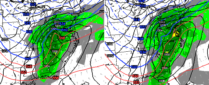
This has the look of an accumulating snow for most of Kentucky. The European Model continues to try to make this into something a little bigger. Notice how it develops a wave of low pressure along our boundary that merges with a storm rolling up the east coast…
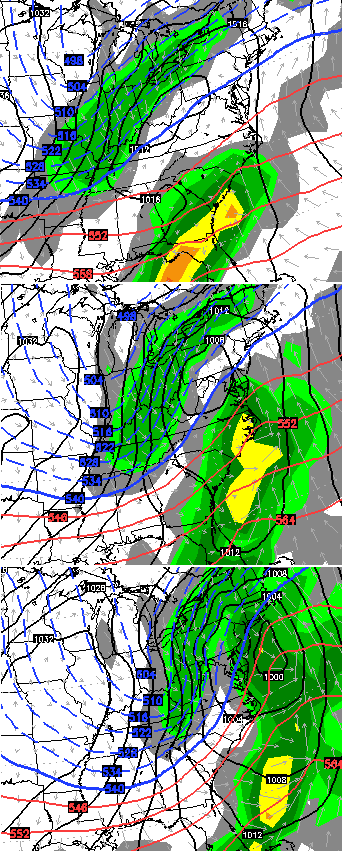
That would be a light snowfall across our region. Winds would be very gusty as arctic air moves back in as the flakes fly.
The model then brings another system diving in from the northwest late this upcoming weekend…
 This is a busy pattern taking shape over the next few weeks. Let’s see if we can make up for lost snow time.
Enjoy the rest of your evening and take care.

sounds great
Best part about the Wednesday night/Thursday system is that it should be all snow and not a rain to snow system that rarely pans out.
I wouldn’t count on there not being rain somewhere in that time frame. Locals in my viewing area of far NE/KY already have it in the forecast for Wednesday night followed by the dreaded wrap around/ backside flurries.
Don’t even know where to start. Want to be optimistic, but with the way this winter has gone it has been it just doesn’t seem to go out way. Looks promising now! Not sure it will look the same Wednesday morning though.
Thanks for the update CB.
Don’t even know where to start. Want to be optimistic, but with the way this winter has gone it has been it just doesn’t seem to go out way. Looks promising now! Not sure it will look the same Wednesday morning though.
Thanks for the update CB.
Earlier today I could not post. Now it posted my thoughts twice.
Best comment ever!
lol
With the temperature profiles for the next 2 weeks, if we get any snow, it will be rain changing to snow. It will be 40`s Tuesday, 50`s Wednesday, 20`s Thursday, 40 and 50`s Friday and Saturday, etc.
This will get us to the middle of this month. After this, if we do receive any snow, it will melt quickly. I`ve given up on a good snow for this winter. A good snow is 6 inches or more that stays around for a few days, not melt away within 36 hours.
I’m just here so I won’t get fined.
Like
I really hope we can get something big in eastern and southern Kentucky. I’m ready for a good snow like we had in the 90’s.
As stated before; it looks like another heavy rain-maker. Temps are going to be too high for any snow to fall.
this is arctic air.
it might rain at the beginning but it’s going to change the snow quickly.
It will change to snow……flurries that is on the backside.
the arctic air that never arrives lol a day here or there has been about it
I’ve just about lost all hope for snow…being let down time after time really wears on a guy 🙁 lol
Accuweather is calling for 2-4 inches for ashland ky. Wonder if that will hold true?
Gosh sakes: everybody reinsert ones binky – if able – and take a corrective nap. Wake up and come to terms with whatever the weather brings.
Prefer just rain if tiny snows. The salt ain’t worth it. Seriously lame having higher accumulation of salt than snow. Just like a lot of the tweets that poster think is mainly snow.
They salt for rain to true story lol
Festive flakes….❄️❄️❄️❄️❄️❄️❄️❄️❄️❄️❄️❄️❄️❄️❄️❄️❄️❄️❄️❄️❄️❄️❄️❄️❄️❄️❄️❄️❄️❄️❄️❄️❄️❄️❄️❄️❄️❄️❄️❄️❄️
Emoji’s work on here? Let me test… ☺
Always looks good before then we end up getting NOTHING at all 🙁 NEED A SERIOUS DUMPING OF SNOW ALREADY!
I’m going to Utah in a few days?
I don’t know, are you?
What’s going on with the big temp difference forecast for Saturday? WKYT forecasting anywhere from 7-10 degrees colder than most others. Will be interesting to see who wins out.
Nothing to see with the snow tomorrow. An overachiever may spit out 1″.