Good afternoon, guys and gals. It sure is nice to see the sunshine out there… too bad the temps aren’t recovering very much. Those numbers will take off early Wednesday as a strong cold front gets set to plow through the region with a band of light snow.
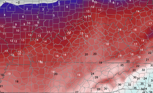
Wednesday temps may hit 50 degrees with winds cranking up. Those winds will be just ahead of our front that moves through during the evening. A band of light snow will be located behind this front and it will quickly race eastward across Kentucky.
Light accumulations are likely with some areas picking up a quick inch or two. Gusty winds will blow whatever snow we have around into Thursday morning. Temps will continue to take big dive and will be deep into the teens to start Thursday…
Check out the wind chills at the same time…
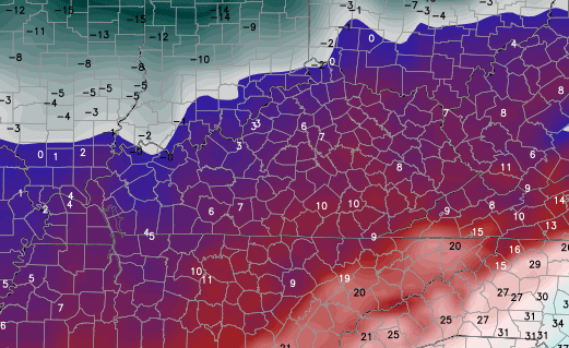
Highs Thursday should stay in the low 20s for many as skies become partly sunny.
A nice recovery is on the way for Friday and Saturday with another system dropping in from the northwest late Sunday and Monday.
I will update that and what else is rolling our way next week coming up later today.
Make it a great rest of your Tuesday and take care.

Heading into the last three weeks of meteorological winter with little to no snow for most. Going to take a big event to make this winter one to remember. Looking forward to the warmup Saturday.
33/32 boo.
boo hoo
What does this mean?
Most of our precip falls as rain and then the temps hit freezing after most of the precip is gone.
Happy Dusting Day 17th anniversary. Hard to believe it has been 17 years since the “dusting”. I’m not too early, am I?
At least there are only a month or so of the “next week”
For at least one child, it will always be too late.
Hey Chris, will you be releasing a Spring Outlook?
When CB does that, you know snow chances are probably done 😉
Wow…what a weak, wimpy, whacked-out Winter we have this year.
To be perfectly honest, after the winter myself and my family suffered last year, I’m glad that things have not panned out the way they were originally forecast.
I’m also glad that we didn’t get the cold like last year. Nothing sustained this year as far as prolonged periods of cold. I think every week in January had at least one or more days reach 50 degrees.
SEKY got all the cold last year with very little snow. Not a good combo in my opinion.
Print this out and put it on your windows. Arizona from last winter.
http://i.imgur.com/GNR69lv.jpg
If you want something similar (same place) for a phone background.
http://i.imgur.com/16BXe2W.jpg
Rodger is DONE! Models showing the Wed night event dryer and dryer and Sunday event is rain! What a joke this winter has been! Ready for spring! Rodger in Dodger!
Come back Rodger!! Don’t cliff jump yet!!
I’ve thrown in the towel. This winter, based on the Pacific SST’s, has been a major disappointment. I thought 20 inches of snow at SDF was a given, especially after the mid-November snow. Right now, I think it’s more likely I’ll need a swim suit before I need the snow shovel. The models have always been promising a week out, but they have not verified. It’s frustrating because we really only have about ten weeks to make winter work. It’s such a small window and things just never line up right.
Test
I give up the blog wont let me post more than one sentence.
Hey, carefully watch the words you are posting. The autobot will not let anyone post coments with words like bluegras-s, as-sociation, certain-ty, etc. And you can see why, except for the “certain-t one because autobot disapproves “tain-t” part of the word.
I always copy my comment before I post it so that in case it gets lost into cyberspace, I can check back and reword, delete, or rearrange it.
If you cant find whats wrong, press on your keyboard (if on a computer) CTRL+F and search for the “bad” word it is finding.
Everyone cheer up all it takes is one storm it could happen it April done it before
Problem is, by then, most of us don’t WANT it to snow!
One good thing about April snow is that it doesn’t stick around for too long. No way would I want to look at a snow in April for more than a day or two.
One bad thing about snows that late in the season is that if we have a hard freeze then many blooming plants can be severely damaged.
what is the difference in having snow or cold in april and having 70s or 80s in the winter for a brief period……..i am hearing not only on this blog but others as well that if you are wanting an early spring this is not your year……..wintry weather is supposed to last well into the non winter months………look at the bright side, this is feb. and catchers and pitchers report to spring training within 3 weeks…….can’t wait for that to happen………god bless every one on here.
How about a Valentine’s Day snow for everyone who loves snow? I’ll order that right now. Order placed and is being shipped out to arrive next weekend of the 14th. There.
Was hoping to use my new quadcopter with hd camera to take some wintry pics of this “epic” winter from a birds-eye-view. Unfortunately all ive photographed is cold sunny days…..bring on the warmth so i can enjoy my two-wheeled hobby
Not that I trust accuweather’s forecasts, but I do check to see what they show for possible snow. Yesterday was 1-3 inches. Earlier today was 1-2. Now it’s a coating to an inch. My boyfriend’s response? “Well, by this time tomorrow we’re gonna owe them snow.”