Good Wednesday to one and all. We have a very interesting weather day ongoing across the commonwealth of Kentucky. It isn’t often we talk about 50 degree temps and snow withing just a few hours of each other, but that is the case from this afternoon into later this evening.
A strong cold front is barreling our way and will give most areas the shot at accumulating snows through early Thursday. This isn’t a lot of snow by any means, but will be enough to cause some issues for travel.
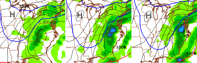
Here’s a breakdown of how things look…
– Gusty southwesterly winds will boost temps toward 50 degrees by early this afternoon as clouds filter in.
– The cold front sweeps in this evening and drops temps quickly through the 30s. Upper 20s will then show up after the snow starts flying.
– Our band of snow will be a fast mover and only give most areas a 3 or 4 hour window of flakes flying. Some moderate snows will be likely during this time.
– Accumulations should generally be an inch or less, though a few spots could do a little bit better than that in a heavier burst.
– Gusty winds will accompany that band of snow and some blowing snow will be possible as temps drop. We will wind up deep in the teens by Thursday morning…
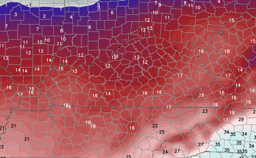
– Wind chill readings may be closer to zero times tomorrow morning…

Temps rebound nicely by late Friday into Saturday with mainly sunny skies. Another system dives in late Sunday into Monday and that one may really amplify. It’s possible for us to go from 50s and sun to rain and wind then snow from Sunday into Monday…
I will hook you up with your weather trackers later today. Have a good one and take care.

Thanks for the update CB. I’ve just about had enough of these little weekly ankle, I mean toe biters this winter. I wouldn’t mind a 1/2 foot snow, but let’s just move on to spring if this is the “new” winter here. We can’t even get in on a “big” miss this winter. Up to an inch has been the most snow forecast for SEKY this year.
Festivaaaa!
Spring will get here when it gets here.
1 in or less…that’s a wild ride I must say. I guess the temp swing is the ride. We are a wild and crazy bunch of guys.
SEKY, the new Georgia for winters.
Actually, GA receives more annual snow. lol
Well I guess it is better than a Refresh Rain.
So what you’re saying is it’s not going to snow…
The more the well intended hyperbole in the post, the more likely snow is not much.
I am pretty confident my two, 2-3″ events this winter could be a bust. Wild such a low estimate is still too high.
The bar appears to have been lowered. I will not say we have nowhere to go but up, since I said that before this winter. Again, my perspective is south of the river. We got nowhere remotely close to the 70″ and 30″ range CB noted.
Did CB actually post that? 70″ seems high for even north KY.
So basically, the same forecast as all the systems before it. As I said before just reissue the same forecast with each storm. Same thing will go down on Sunday.
Actually Sunday will be less snow.. Lol
More than likely our Spring will be cold and wet…not snow.
my white flag/ towel is thrown in…
Unless there is a miracle blast of snow coming through here, in the next 4 weeks, I will see all of you next winter.
The snow lover in me and most of you has been crushed with festive flakes and an inch here an inch there. Even 6″ of snow wouldn’t get me all that excited. I had enough pics from my friends/family to the north from Sunday’s storm to just crush my spirits. 2 feet of snow in Chicago?!? Thanks for the pics, Mom!
Stick around we still got the spring severe thunderstorm season upcoming. I think.
Might be kind of meh too, but that also is a win IMO 🙂
I like nothing that knocks my power out… Ice, heavy snow, high winds, giant trolls etc.
You gotta get one of those fancy dancy back-up generators.
Saturday looking to be a fantastic day …. I bet SE KY hits 60 degrees that afternoon – time to get the clubs out.
I’m ready for severe weather at this point.
Winter is over baby, last one out turn off the lights.
Thanks for the update and all the hard work you do!!!
Sorry I cant help it: I find it VERY FUNNY on KYT morning video that it says WINTER STORM SETUP for tonight…and says a coating to 1 inch possible. I guess we are so desperate we call that a winter storm setup!
Compared to this years events it doesn’t take much 😉