Good Thursday, everyone. A blast of winter weather is rolling across the bluegrass state today and this will create some travel issues. Snow showers and squalls are introducing the first of several arctic air masses to influence our weather in the coming days.
Light accumulations will be possible today across central and eastern Kentucky. This will be a powdery snow that will blow around with very gusty winds. Considering we are dealing with snow showers and squalls… visibilities can be greatly reduced in local areas. It’s one of those days when you get a blinding snow to a few flurries within just a few miles. Travel through early this afternoon will be tricky at times.
Temps will drop into the upper teens and low 20s and then rebound a few degrees this afternoon. Gusty winds will make it feel much colder. I will have your tracking tools in a bit.
A few flurries will be possible Friday as we find ourselves in between arctic fronts. That next front blows into the region Saturday afternoon and will bring more widespread snow showers and squalls that can put down some accumulations. Gusty winds of 30mph+ will also be noted as temps take a nosedive behind the front…

Blowing snow is a good possibility with that type of a setup. Lows for Sunday and Monday will drop into the single digits and could flirt with zero. Below zero wind chills are a good bet at times.
The models continue to advertise a winter storm from the plains states into the Ohio Valley early next week. We are now 4 days away from that storm potentially impacting the weather across Kentucky. Let me be clear… it is still too early to know what impact, if any, that storm will have on our weather.
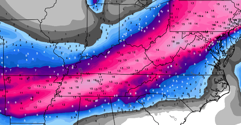
If the computer model forecasts are to be believed, this system could have a big impact around here. The GFS snowfall map…

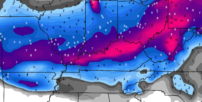
The European Model Snowfall map…
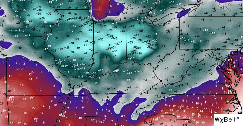
The Canadian Model snowfall map…
As we are fully aware, a lot can change with computer models from 4 days out. The one difference in this POSSIBLE storm and the systems we had earlier this winter is the arctic air. If this storm does develop, it would be sending moisture into an arctic air mass and it would also have another blast of arctic air coming in behind it.
Again, take all model runs with a grain of salt until we get into this coming weekend. We will still get model deviations showing up from run to run and will begin to look for true model trends later Friday and Saturday.
If we can get a decent snowfall out of this… look out. Temps behind that would tank and the models are going crazy with the cold…
Again… IF we can get a decent snow on the ground.


Hamburg Area from WKYT Studio
Lexington

I-75 @ Winchester Road Lexington

US 60 @ US 127 Frankfort

US 127 @ Frankfort Frankfort

US 60 @ US 460
Frankfort

I-75 MP 127
Georgetown

I-64 MP 97
Winchester

I-71/I-75 at I-275
Near Covington

I-275 at Mineola Pike
Near Covington

I-275 approaching KY 20/Airport
Near Covington

Bluegrass Parkway Bardstown

I-65 MP 32

Downtown Louisville @ 2nd & Broadway
Louisville

I-64 @ I-264
Louisville

I-264 @ Freedom Way
Near Louisville International Airport

I-75 at MP 36
London

I-75 at MP 23
Corbin

I will have updates later today. Take care.

Oh my God, stay calm everyone, stay calm. This is going to cause a TON of talk among the public now. I can see everyone later today and tomorrow start saying we’re going to get 1-2 feet of snow. Even myself gets super excited to see a map like this SOUTH of us at 4 days away, meaning a possible Northwest trend with a stronger system. But the storm is still thousands of miles away and we should wait until storm is accurately sampled. If you keep your expectations very low, you’ll never be disappointed. (That’s what I do in the winter, and what you should do too!)
Dumb question: Why is confidence so high on the arctic air a week or MORE ago, and yet we’re 4 days out from a potential snow and confidence is low until almost the day of……The arctic air was 1000’s of miles away too a week ago. I’m assuming air temps are easier to forecast than precipitation in the long range?
Yes! That’s when we will see the real deal as to what happens….But, the Boston blizzard was predicted days before it was “sampled” … Just sayin’
And the mayor of NYC shut the city down for what, a 4-5 inches? Fail.
Yes, the blizzard of 2015 was a half bust.
Rodger says thanks for the sermon. He thinks we’re all big enough adults to get our hopes up at our own expense.
Most models edging south this morning. Could southern Kentucky finally bust its dome?
Rodger in Dodger!
It’s been pouring ice for about 10 minutes here where i live in the north eastern part of ky.
This IMO is the most important thing to take from CB’s post as far as next week:
“Again, take all model runs with a grain of salt until we get into this coming weekend.”
Short of CB making this bold fonts with twinkly lights, it seems pretty clear do not buy in yet and fall for the ball.
Yet look at the post above yours and we have another “agendite” on our hands.
I have 1600 lbs of “grains of salt” that need to be spread.
so I question as to why even print anything? if it’s too far out and you don’t want to speculate, then common sense says just keep quiet about it …. that’s about like saying it’s going to be 70 next Saturday, the models are showing it – well lottie freakn da, things change overnight ………..and no Hamilton I don’t have an agenda, just speaking my mind !!
So if you were filling out a 7 day forecast for TV as your job, what would you put for Monday-Tuesday based on what those models show?
Somewhat surprised to see Accuweather forecasting 4-8 inches of snow for the Mon-Tue timeframe and The Weather Channel also showing 3-5 on Tuesday and Wednesday. The NWS in L’ville want put numbers on it yet but obviously see the same potential. And the long range models I looked at explain why they are putting those numbers out there.
C’mon (old) Man (winter)! Give us one decent thumping of snow then move on and let spring, well, spring!
Accuweather is also saying 4 to 8 inches in Cincinnati, but the NWS is saying a mix of rain and snow, with temps 4 degrees higher than Accuweather.
I cannot even type two letters correctly this morning. This may not be a good day coming.
OK, you CAN plan for a big snow. Our garage door opener broke last night which means we can’t get the snow blower out…. so it WILL snow! Just sayin’. 😉
The weather channel has been pretty accurate and are really high on the European model when forecasting snow storms.
LoL… Sorry you said Weather Channel
The 06z GFS model run looks fantastic for winter weather lover’s early next week.
Location Location Location
In the past I would hate to be In the sweet spot for a storm four days out. But with the artic air pulling in and being cold before the low arrives I can’t help to get a little giddy about the potential. I know no one likes ICE, but it could be on the playing field when this thing finally comes to fruition.
Thanks for the update CB. Going to be some fun tracking.
I’m giddy with you. The models have been somewhat consistent. Again, this weekend will nail it down but I think the snow gauge is half full.
We are about due for our usual ice event, but CB would already be noting it if he thought warm air aloft could be a big factor…. Unless of course he is waiting for the weekend.
Models are pretty darn good outlooking ice.
He did acknowledge it being a possibility in a tweet.
Oh by the way…… 35.8 here in my part of Knott County
Apps is going to nibble but not bite until the weekend…
I agree 100%. Look what happened two weeks ago. A four day storm moved 200 miles north with the rain snow line. The snow lover in me is lining up a 60 yarder with Lucy holding the ball.
Trends are trends!
This from NWS Wilmington regarding the Tuesday potential:
THE NEXT SYSTEM ON TUESDAY IS BEING PROGGED TO COME FROM THE GULF
STATES AND THE TN VALLEY AND BE WELL AHEAD OF THE POSITIVE TILTED
L/W TROUGH OVER THE CENTRAL U.S. THIS LEADS ME TO NOTE THAT THE
PREVIOUS SYSTEMS PROMISING MUCH SNOW IN THE REGION WERE OF SIMILAR
ORIGIN WITH LITTLE UPPER SUPPORT. CONFIDENCE IN THE FORECAST TANKS
FOR THE LAST DAY OR SO IN THE FORECAST BUT HAS THE POTENTIAL FOR A
WINTER EVENT OVER THE REGION.
So I guess we shall just have to wait and see how this unfolds!
Get the rulers out I feel good about this storm….Can you say SNOW ICE CREAM we are so due here in Campton
I’m coming to close to kicking the football on this one, trying to hold off
NWS Jackson KY seems cautiously optimistic.
ON MONDAY A LARGE SCALE UPPER TROUGH WILL BEGIN TO TAKE SHAPE OVER THE ROCKIES AS A WAVE DROPS SOUTH FROM CANADA. THIS WILL LEAD TO SURFACE LOW
DEVELOPMENT OVER NM OR TX ON MONDAY…WITH THE LOW THEN TRANSLATING EAST ACROSS THE SOUTHERN UNITED STATE. BOTH THE ECMWF AND GFS TAKE THE DEEPENING SURFACE LOW JUST EAST OF THE APPALACHIANS IN THEIR LATEST RUNS…WITH A TRACK FAVORABLE FOR
SIGNIFICANT WINTER WEATHER IN OUR AREA. WHILE THERE IS PLENTY OF TIME FOR FORECAST CHANGES TO OCCUR…THIS SYSTEM DOES BEAR POTENTIAL TO END THE SNOWFALL DROUGHT OF THIS WINTER.
Looks like the Saturday temps for Monticello have trended a tad warmer up to 42. A day or so ago the thoughts were 30’s with a few flurries, now we’re looking at a shower to flurries. If the temperatures can’t stay settled in the 30’s here through Saturday will that have any bearing on the system at the first of the week?
Even our own local weather forecasters here in western,ky are saying snow possibility Monday nite and tues. That hasn’t happen since they forecast the snowfall we got back in November.
Good hard snow right now in Bourbon County
We shall see. That’s all I can say at the moment.
Still calling for a lake cutter or another Hoosier and Buckeye state storm. Or worse, we get the cold rain with festive flakes at the tail end.
Ready for spring. Yeah I know Jeff Hamlin, spring will get here on its own accord. So smoke your stogie and let us rant.
Cold rain will be freezing rain so yeah that would be worse.
Talking about the usual 35 degree cold rain. Geesh.
Pretty sure his point was that if it does rain the ground temps would be so cold that it would freeze on contact.
Thanks
Better than a 33 degree cold rain….ha ha
100% this
We’ve got snow coming down in my neck of the woods!
Reports of snow in Laurel County
Snowing in Knox
Although not very big these are the biggest snowflakes of the yr
Radar showing snow all around me. Yet nothing falling from the sky? What’s the deal?
Some people are getting way too hyped about the possibility of winter weather next week (and no, I’m NOT referring to Chris Bailey – he’s being realistic and cautious). You should know better by now than to get your hopes up so far in advance!
Thanks for keeping us informed, Chris.
For snow agreed 100%, but if CB starts calling ice, we will almost certainly be in Ruh-Roh! mode.
We do not want the word “ice” to be part of CB’s updated posts, since we know which it likely fall if be if between ice or snow.
Could really be bad if ice. Not to mentioned the cold that follows.
Looks like some weather agencies are getting hype too, which will only further the problem of even getting to a grocery store this weekend. Maybe this one has some actual bite. I’m calling 4-8 inches for Eastern Ky, with locally 10+. Slump Buster!
I’m seeing right at half an inch of snow here in Lawrence County and its still coming down!
0.75 inches in Annville ky
Today’s snow has been another massive disappointment in my area. The Charleston NWS even issued an advisory early last night, very unusual for them. We have barely had any flakes let alone the 2-4 predicted. This just fits right in the Winter as a whole.
Wow, gang, it is quite the snow squall here in south London, about 2 miles south of downtown London actually. Winds have whipped up, and the ground is entirely covered, probably our second biggest snowfall this year.
absolute white out driving on Hwy 30 at the Laurel/Jackson line …. roads not slick but very hard to see.
It looks like Mon/Tue system is headed way south!
GFS comes in with a much further south snow track. All but eastern KY misses out on the snow. Ha! Doesn’t mean it’s right, but humorous the last one correct north and this one might correct south.
12Z Canadian also shoving the storm to the south. Mostly a big hit for Tennessee. Like I wrote, it would be humorous to miss last week’s storm to the north and then next week’s to the south. Only in Kentucky!
A big hit for Tennessee equals a win for me as I live in a border city. A bug hit for northern KY almost always equals little to no accumulation for those of us from London and Somerset to Middlesboro.
Yep, GFS and Canadian still looking good for SEKY. Of course if it continues to go south then that could change in a hurry. It will be interesting to see if the Euro, which was the farthest south of the bunch yesterday will go further south or if the others are just coming into line with what it was showing.
We have about 1 to 1 1/2 inches of snow in the Burning Springs area of Clay County. It is snowing really hard with big flakes.
Arctic air shoving next week system way south.
Good to know some are getting snow…we have had a few flakes (festive) but our temps are still near 30. Winds are starting to kick up a bit…still hopeful for some white stuff.
Same here MT. We had an advisory last night for 2-4 inches in my area of WV, they revised it to 1-2 sometime this morning. Now down to less than in inch predicted. We are not going to be remotely close to that. So far I could practically count the festive flakes we have received. I also see where the locals here in Huntington WV area have bumped the highs up above freezing for Saturday so as to get some rain involved, surprise, surprise. Also next week is rain too with the dreaded backside flurries.
Anyone know if North Carolina will get any snow from next Wednesdays system? I used to follow this site religiously but I recently moved to North Carolina. It feels like I have to start all over trying to find someone I can trust with delivering the weather here and I am failing hard. There is no one like Chris Bailey or Brian Goode around here. If there is, I haven’t found them yet.
12z gfs run sucks! Its way to far south lol. Just one run many more model runs to go.
Just a smidge
Apps seeing big ice storm stretching from Arkansas to N. Carolina..We
may not want this to shift north..Ugly