Good Thursday evening, gang. Snow showers and squalls are winding down out there as temps drop quickly through the teens. Single digit wind chill numbers are also showing up.
I have no changes on where we go for the upcoming weekend. Another arctic cold front barrels its way in here on Valentines Day with very gusty winds, snow squalls, slick roads and bitterly cold air. Temps by Sunday morning drop into the single digits with wind chills below zero.
With the Saturday forecast pretty much a given, it’s time to really focus on the potential coming early next week. This is looking more and more like two systems impacting our weather. The first system may bring a swath of snow from west to east Sunday night into Monday. The European Model shows this possibility…
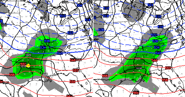
The NAM only goes out through 1am Monday, but has a similar look at that time…
 With very cold air in place, it shows a nice fluff factor with any possible accumulations…
Keep in mind, that just goes through 1am Monday. We shall see how that system looks in the overnight runs because that is now within our window to watch for trends.
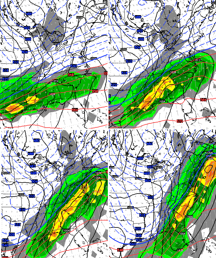
The second system looks much stronger and is just outside that window for Tuesday into Wednesday so we have a few days to wait and watch for trends with that. Here’s the latest from the European Model…

If you’re a staunch believer in a northwest trend for these storms… you probably like what you’re seeing. 😉
A full update comes your way tonight. Take care.

thanks Chris appreciate your time and effort
ty chris bailey for the timely updates….very much appreciated.
A SOUTHERN APPS RUNNER FOR SOUTHEASTERN KENTUCKY?? COULD IT BE??
Feb19th 2012 may be spot on LoL
Boyd County Ky wants some real snow! My kids are doing a snow dance as I type. 🙂
If the storm is showing up south of Kentucky then this will be the one time the northwest shift doesn’t happen.
how optimistic
The Northwest Trend seems to have reversed on this one. The models have been heading in the other direction.
Holding my breathe and got my fingers crossed.
Bahaha. Drop the E off of that! holding my breath….
I would be happy if the storm pretty much just stayed where it is at. If the NW shift does happen then I look for it to be a CKY storm. I’m all for some of you getting some good snow, but SEKY is much more snow deprived than you guys over the last two years.
Couldn’t agree more. Hope that puppy sets right where it is at. No NW shift please!
I’m not no weather man, but it seems to be shifting to the south
member few weeks ago we got a miss to the south,
But it didn’t move to the south it was in the Gulf and stayed there.
What happened to the GFS? Not even a mention…
He didn’t mention it because the latest run of the GFS had it missing us to the south. Two days ago it had the storm missing us to the north. It seems to be useless right now, so better to focus on models that aren’t so shifty.
This. 🙂
I am more than aware of this. That is not my point.
If you are aware of the models problems with being all over the place at the moment, then why ask a question you already know the answer to?
Figure it out. You all are a smart bunch.
A one word hint. Balance.
Yes, but the waffles appear to be trending south. Simple math example for the north and south waffles:
9, 7, 8, 6, 5, 3, 4, 2
Those numbers waffle up and down, but the overall trend is down. What will prevent the cold air from suppressing the moisture’s direction in this case? Seems counter-intuitive based on the events that shoot north with a lack of cold air.
Genuine question here and not rhetorical. What would make it trend more north if the the cold air is in place? Seems the waffles offset to the north less with each run and suggest south.
If I’m wrong, no surprise since I am not a met 🙂
This presumes it does not break up into two smaller events in the first place.
The North trend will start late tonight on the models. You can already see it on the NAM.
Every time I look at the latest run of the models, it seems that it is falling farther south. I am afraid to look at the models and maps in the morning for fear it won’t even be anywhere near where I live…Ashland/Catlettsburg line. I know it is still too far out to know for sure but it certainly isn’t looking promising for where I live. We were looking at 6 to 8 inches just yesterday!!! Now I see only two inches for us but I will continue to Hope!!! Thanks Chris for all u do to keep us informed!!!
I hear ya! Still holding out hope for Boyd Co.! 🙂
By the time it gets here it will be a Alabama and Georgia storm. Ugggg. I’m going to be so glad when this winter is over. All this cold wasted. Come on spring
I see SNOW PEOPLE….
The new twist for this movie might be ICE PEOPLE.
So every other storm misses us to the north, now we have a promising one poised to miss us to the south. Only in Kentucky! 😛
Jackson NWS talking maybe sleet/freezing rain or a rain/snow mix for Monday. If that happens then I am officially done with winter. I know Hamlin, spring will get here when its ready. Maybe CB can elaborate on why they may be right or wrong. I know a decade or two ago these southern systems would start as rain and go to all snow fairly quickly. Now its mostly rain with very little backside snow.
It seems to make sense. Our last big ice event was a similar set-up. The cold air was in place and spiked up a little, but still was below freezing when the moisture moved in and the cold air kept it right over Kentucky. Mainly ice until Georgetown on north and then a little bit of snow on top for all at the end of it.
Not sure we want any part of this and might want it more due south. No offense to Tennessee, of course. Would be nice if CB refuted ice potential.
Difficult position for him.
Start addressing the *possibility* of ice and he’s “hyping the event”, doubly bad if it turns out not to happen.
Say nothing about it until he’s pretty certain it will happen and then “he might as well be nowcasting it”. Plus, there would be much less time for people to prepare without stressing and rushing around.
Personally, I’ll choose information over the resulting perception every time, but I also have the luxury of not having to answer to an army of critics when it goes wrong either way. Then again, he is in that position by choice, so it tends to even out in the end.
IMHO, everyone should go the ‘victory loves preparation’ route and just plan on there being ice.
Jackson saying the question is how far the system can push the moisture without eroding the cold air? Right now they are calling a rain snow mix. If that’s the case with a single digit morning leading up to the event and then it ends up as a mix, then I give up on southern fed systems. Used to get our big snows from those, but in a decade plus drought now. It may still nail us, but my question is how it could happen then, but so hard now?
I see nothing to suggest anything but snow with the first system Sunday night into Monday.
Thanks for no “………” after the Monday 😉
praying and hoping for some good snow in laurel county!! it seems as if all the good snow has gone to the north or to the south or all around us for the past two years!!
the question is CB …do u believe in the NW trend?
The force is strong, my friend. 🙂
00Z GFS running now
the nam is still north.
I’m leaving for Louisiana for a few days next week so I won’t even be here lol…but I hope the area gets pounded!
00z GFS says nothing to see here fools…..hope you like bare ground and frigid temps. C’mon sunny and 75.
Even more south?
Lookout Atlanta.
Nope, it will trend north- to Tennessee 😉
Come on NW shift!
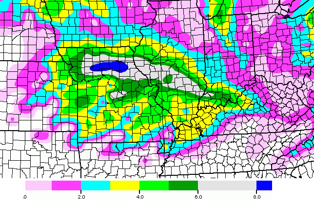
No Northwest shift for tonight’s runs so far, the latest 00z NAM and GFS have shifted even more south. GFS has snowflakes down towards the Gulf of Mexico into Florida, with 2-4″ around Atlanta. And Wow, as I am typing the Canadian model is currently running pushing the heaviest snow south enough to miss TN and pounding Atlanta with a general 6 to 10″! Less than an inch for all of KY. The biggest of all the models (ECMWF) should start running soon. Will be super interesting to see what it will show.
So the NW Force is not from the great episodes 4, 5 and 6, but the weak Jar Jar episodes 1, 2 and 3 😉
Good news over the weekend is northern shift! Bad news it shifts so far south the northern shift is into Tennessee for most action. Not really joking much here perhaps.
Yeah, that’s why I don’t want to see it go even further south, because if it does, when the northwest trend kicks in, it will still be too far south to give KY a pounding of snow. Keeping my fingers and toes crossed!
ECMWF currently running… CB should have a new post soon too…