Good Friday to one and all. We’re making our way into our big Valentine’s weekend and tracking a lot of winter weather. It’s a pattern that looks very harsh for much of the country over the next few weeks with no signs of an early spring anywhere to be found.
Today is fairly tranquil when compared to what’s on the way. Highs today will mainly be in the mid and upper 20s with gusty winds making it feel even colder. Clouds will battle it out some some rays of suns and a few flurries may even dance around.
Our arctic boundary for Valentine’s Day looks stout…

Here’s how that looks to play out…
– Temps spike toward the 30s by late in the morning as winds increase ahead of the front.
– The front surges in during the afternoon with temps dropping 15-20 degrees in an hour or two.
– Snow showers and squalls will be likely behind this front. Some accumulations will be a good bet and that could cause some travel troubles because of slick spots and reduced visibilities.
– Temps by Saturday evening will be ugly…

Sunday morning readings will likely drop into the 0 to 5 above range with wind chills from -5 to -15 possible.
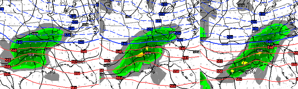
High temps on Sunday will only be in the teens with an increase in clouds. Those clouds are ahead of a potential snow maker streaking in here from Sunday evening into Monday. The latest trend with this system is to make it stronger with more moisture.Here’s how the NAM sees this…
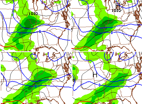
 The European Model…

The UKMET has the low farther north into southern Tennessee with the arctic high across the Great Lakes by Monday evening…
The GFS isn’t as robust with thatsystem, but has much more juice than what prior runs were showing…

Whatever moisture comes with this system, it will be falling into arctic air in place across the state. That will help maximize snowfall ratios.
With much more of a system showing up from late Sunday into Monday, that keeps the next system much weaker and farther south and east for Tuesday and Wednesday.
Let’s see if this late Sunday into Monday system continues to show up stronger with future model runs. Regardless… it gets bitterly cold again for the middle and end of next week.
I will update things later today. Take care.

Most systems have missed the Louisville area by going north. Now this one will miss us by staying south. We cant win anymore when it comes to 6 inch or more snow falls.
love the Trend
we we might not received biggest snowfall in Louisville but we are a player.
we should know more with the upcoming 0z Runs later this evening.
Jackson NWS— significant snow for early in the week has lessened. —— enough said. Another winter with no big snow. Bring spring.
Well hopes crushed again. The models have gone even farther south. I am not blaming you Chris! It is what it is !!! Thanks Chris for all u do!! Have a great weekend everyone and stay safe!!!
My thoughts on the next two systems. Saturday will be another non event snow wise, like yesterday’s, it will another dry very cold day follows. Next Monday one of 2 scenarios. First, Cold air stays in place forcing storm across dixieland then a sharp left turn and it crushes New England again missing us twice. Second, storm comes further north providing a southwest wind, blows enough warm air for 35 degree rain with the dreaded backside flurries. We lose either way. But I would pick #2 because of our track record this year.
Tennessee was looking the most likely last night for north shift, but was hoping for the Star Wars episode 4,5,6 Force shift north rather than the Jar Jar 1,2,3 Force shift. Those IMO were weak movies like the north shift appears hear.
Warmer air in place it goes to the north and cold air in place it goes to the south. We can’t seem to get a ‘tweener’ that gets it over Kentucky and one of the rare times we did since 98 was a big ice storm seven years ago. Truly uncanny how this stuff pans out, but mother nature badger don’t give a shoot.
here. Whatever. At least no ice 🙂 Winning!
I think we should all move to Cape Disappointment.
With this models originally running north, and now giving us that southern track, I think I’ll just keep my mouth shut on this one. There’s no need to make myself sound like an imbecile, this time.
The models a week out do that for us 😉
The past few weeks I’ve been almost dead-on with my predictions of the storm going north. I don’t remember seeing one completely jumping south of us before, so I cannot predict the pattern seeing as how I’ve never witnessed this pattern.
So now there are two systems of interest. Sunday evening will shift further to the north and the second weaker system will travel along the snow pack of the first. Going to be interesting to track. Wish the first wave would hold back until the energy from second could make it one strong system that the models where first hinting at. Looks like we are all going to have a chance at a little snow with the cold rolling in behind it should make for a FESTIVE few days with snow on the ground. Way better than cold and dry.
The catch is the shift appears needing way north even for Tennessee to be the sweet spot. The next one will probably be too weak to stand a chance of northern action that is significant for Kentucky.
More than five days out is pure model fiction for Kentucky. I still get confused when folks hang their hats on rationalizing models waffle. Even when models waffle, they tend to waffle less in one direction and more in the other with each run and that shows the apparent direction. This one is doing it, as have all the others.
Still would like to know why the models nail Kentucky a week out and then shift like clockwork. Almost like Kentucky is a mathematical set-point for the models orientation when a week out.
only because if you bullseye Ky a week out your guaranteed one of two things, it’s going to go north, or it’s going to go south.
Good point! People in Ohio and north might be saying, why do the models always miss them a week out and then- bam! 😉
Poor wittle’ them 🙂
Must be that we are geographically centered between the north and south. As well as east west when you look at the gulf states. Start in the middle and work your way around us is my thinking. If the storm is not being sampled by the weather balloons in the states then there is no use looking at models. They are just eye candy four days to a week out.
Think about this though:
We haven’t had any huge precip storms in a LONG time (for this area), at least none that have amounted to much – whether it be liquid or frozen. We did have five inches in Lexington but that wasn’t a widespread precip event.
Not that widespread. Us folks the other side of the river got almost bo-diddly.
Droughtmonitor.unl.edu
We are in a moderate drought at the moment. 23% of Kentucky was in a moderate drought last week. Now 51% of Kentucky in a moderate drought, now that is a huge jump! CB did mention that this upcoming summer *could* be a dry one. My bet is that this will be a drier than normal summer, it’s been 3 years since we’ve had a dry summer. So Yeah, it is dry out there, hopefully we can get some good rains in the spring to wipe the growing drought!
yep to far south,lol we nrrd Xanax to cope with this bull crap, going quit the blog till 2 days out for systems. be lucky see a inch or 2 in the south.
You guys sound like a bunch of Gooblers using all of this weather lingo..Oz runs,Models shifting,running north, running south, trending here trending there, mathematical set-points good grief. The Barney Fife’s of wether forcasting. Just leave it to Chris…he knows what he is doing.
Oh well, I believe most will get a few inches which better than the usual flurries most of us usually get.
Lets be clear, Chris specifically said several times not to count your chickens before they hatch so to speak….he did not hype this potential, several of you folks on this blog are the guilty ones of that because you once again bought into the same models that have consistently been wrong from a few days out ALL winter. Even Rolo didn’t buy into them! lol
Just like it’s also possible not to buy into a model solution from three days out. The last storm that missed us to the north still had Kentucky in for it three days prior. Take the temperatures and whether they are high/low based on modeling. Last night seemed to be a few degrees warmer than what was called for, which would (in my opinion) grant a possibility for the models to come back north somewhat.
See, folks got all excited for nothing. It really is amazing how much the models can change in a day or two..
No snow for you.
GFS ensembles are way further north than the operational run. DT over at Wxrisk.com (facebook page) doesn’t believe the southern shift. In fact I think what he said was that anyone who believes this storm is going to go that for south needs their head examined.
Still would appear to suggest Tennessee being the sweet spot rather than our fine state. If the systems were combined as one event rather than two it might of had a chance to force more north.
Banter and models aside, mother nature badger don’t give a shoot.
Only problem that post was written on the 10th
Nope, it was written last night when he was talking about the models as they came in.
The optimistic me see’s an apps runner with KY getting the best of the snows. NW shift has been a trend for over a decade most of the time it occurs when temps are not as cold as what they are forecasting. This sets most of KY up for some wintery precip. but not all snow.
Reality is this will continue to push south and we get nothing while Atlanta gets a blizzard.
Trends are trends….Think Snow or Festive Flakes or Refresh Rain
If it was a rainmaker it would run right over top of us. I’m willing to bet we will struggle to get ball games in this Spring.
Just comparing NAM model runs. It appears the midday runs have more precip and are further north. Still waiting on GFS and Euro to see if its heading back north again.
I am not sure what the GFS is doing but it seems it has almost lost it/suppressed it WAY south.
according to John Belski
the NAM model shifted slightly south
Western Kentucky looking good with this run even Nashville gets a little love
To all you people who knows far more about weather than I do, Is it still possible that this potential storm to shift north? I think I read that some where in this blog or was that just wishful thinking?
There have been so many changes in the recent models, anything is still possible.
Thanks Chris for addressing my question. I so appreciate you and all the things you do to keep us informed!!!!
Oh Canada coming back North..The 0z euro ensemble snow mean looks good for southern and eastern ky..Tenn is the big winner..But a few more shifts and Ky will be the Big Dog..
I sure hope we get some here in east tn..we haven’t had any snow at all this year…
Current models pushing Northwards a bit, making Western KY and Southern KY good candidates for snows up to 8 inches. Rebound to the former glory from a few days ago? We shall see.