Good Friday afternoon, gang. Our weekend of weather continues to look harsh with a strong arctic front arriving Valentine’s Day and a potential snowmaker following that up late Sunday into Monday. Let’s look at where things stand at the moment.
Temps spike ahead of the arctic front early Saturday. That slams in here from northwest to southeast during the afternoon and evening. Wind gusts of 35mph to 40mph will be possible. A band of heavy snow showers and squalls will accompany those gusty winds and that will create some ugly travel conditions. Blowing snow is a good bet!
Temps crash into the single digits and low teens Saturday evening with wind chills going well below zero and holding there into Sunday morning. That’s when actual temps have a shot at hitting zero or a little below. The models are close…

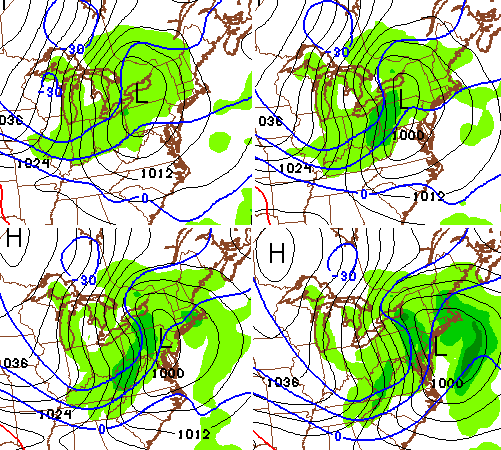
We really need to watch late Sunday into Monday for the potential for a decent accumulating snowfall rolling eastward across the state. The NAM continues to pick up on this…

The new Canadian Model has a similar overall look…

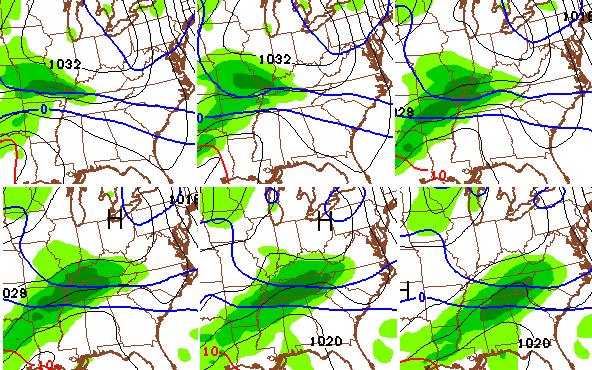
With arctic air in place, we would be able to maximize the snowfall numbers. The GFS is still not on board with that potential, so we will see if it caves later today or tonight.
There’s the possibility of an upgrade to a WST later today. I will see you this evening for another update. Take care.

Thanks for keeping us informed, Chris.
How much you thinkin for sat snow? ?? Inch?
coating to an inch 😉 copy and paste
In my opinion its a toss up. I wouldn’t even give snow amounts yet. The models are as confused as Mike Tyson in a spelling bee.
U mean a toss up for sat? less than 24hrs?
No im talking Monday system.
12z GFS is just not our friend for snow lovers. Way too much discrepancy in the models. Looks like a situation where some will see a decent snow and others wont. Im not sold on the GFS theory its pushing the precip way too far to the south.
Cmon, verify 10 inches for Paducah!!! Heheh, only in my dreams, but let’s still hope. 😛
As of now you got the best potential for a decent snow.
You guys, come on now, it’s never going to fly if you keep up this Debby Downer crap. 🙂
http://i.imgur.com/n5g75bY.jpg
I dont think Mother Nature gives two hoots about if your a Debbie Downer or not.
I do….HOOOOT, HOOOOT and here’s another….HOOOT!
12Z this 12Z that, trending north, trending south, GFS theory, discrepancy models…too much weather lingo…stop because you sound silly…leave it to Chris..he knows what he is doing!!
What is WST?
Winter Storm threat…
Let it snow!!!!!We are definitely due a big snow!!! Tired of these coatings!!##
CB truly rocks some serious hard, but I wish he and other mets would stop calling winter weather “wintry” on the winter. Seems too ironic. Am I wrong in this view?
No! But is I am about ready for some springery and summery weather to roll through.
Still think a shift to the north will happen.
I hope you’re right.
it would be good for Louisville.
That seems awful north, but I did not sleep in a Holiday Inn Express last night.
I am 100% with you on that! Saying “Wintry” has become a custom among all mets. I am originally from FL and when I first heard about “winter weather advisory” or “winter storm warning” I thought “Well… that’s a stupid name. What is wintry?” I have become used to winter terms like flurries and snow squalls, never ever heard of all these words before in my life when I lived in FL. When I first heard of squalls, I would only hear that when a thunderstorm squall line would go through, but now I know snow squalls are just intense snow showers. And don’t even get me started with freezing rain, I was like how in the world is that even possible? I knew none of this because I had never seen snow in my entire life until 3 years ago. I was very naive to all this!
Ah! I can’t believe my area has missed so many snows due to the northern trend and now we are missing out due to a southern trend?! I’ve still got my fingers crossed that the models will waffle again. But even if they don’t I do hope you all in southern KY get dumped on (by snow and not ice)!!
Local forecasters are pretty much ruling out the storm for next week in the tri-state area of Huntington/Ashland. They say everything to the south. Tomorrow will be the usual dusting/trace then very cold.
A met I speak to from around this area said he is tossing out the GFS atm. They say the upper air data is not matching what the surface is showing and its trying to develop a surface low without any upper level support
These storms almost always end up trending further North. Waut and see. If that happens could put us in a nice spot esepcially Southern and Southeastern KY. My take! WW
Folks should perhaps appreciate this has to go way north for anyone but mainly further south Kentucky to consider a winter storm. Some might read CBS’s post and think it would be more than just that area. Kind of surprised CB mentions a storm chance for Kentucky, but perhaps he sees something thrle models are not showing. He is a met so makes sense 🙂
Confused: Looking at day 3 of the HPC winter weather, it shows most of Missouri in slight risk of 4 plus inches. That’s not south of us, it’s almost due west of us. And if it’s an east to west storm, I would think it would bring that straight across most of KY…….but whatever.
http://www.hpc.ncep.noaa.gov/wwd/day3_psnow_gt_04.gif
KY is kind of like a fulcrum for winter weather events that head to the north east.
It only goes out to 3 days, which is Monday, the main event doesn’t happen until Monday night and Tuesday.
how long has it been awhile since we have had 3 potential snows in 3-5 day span ? my first guess would be a long time …at least it gives us some potential to talk about ….IMO I think the 1 next week will not miss us to the south
28 and bright sun here in knott. Actually feels pretty darn good out
I 64 seems to have some type of mystical power to push snow either north or south. I would imagine that is the reason the models use it as ground zero for their initial 7 day placement
Paducah NWS Office has basically dismissed all this and says that there may be 3 inches at most from weekend into early next week. They said the cold will be the story; not snow totals. Is it just me or does anyone else think that’s a bold statement at this point? I appreciate CB and his thoughts. Let’s all hope for some decent snow.
Seems about right to me and on the high side for a lot of the state. Good luck measuring snow with the wind blowing like it should be 😉
Would like CB’s rationale as to why a winter storm is possible for anyone beyond very southern KY. He may see things the model trends are not picking up right now.
That report was from 4 AM central time this morning, oboro. ur outlook has changed here in Paducah.
*Our
Rodger follows the Paducah NSW discussions and it seems they are nearly always “rooting against” winter storms. I’m reading between the lines but they always seem eager to jump on the “It will miss us” models. Not surprised that their summary of the situation is “no big deal” while the models are still jumping around somewhat. Rodger in Dodger!
Just don’t see a big event for Ky..Seems like with every model run moisture is less…Confusing with these different waves..Why can’t we just get one big wound up low and go from there..With higher ratios still see maybe 4-6 for southern counties close to Tenn…
the GFS is king, NAM is always GUNG HO so ill take GFS anyday
several weeks ago we had system keep trending south as well, sorry folks it aint coming north..
The difference here is the cold air in place. That one went south even without much cold air (figures). Still, I agree that the trend is king so far. The models from an average do not seem to support a big north shift, so would like CB’s take on why he see the possibility. He could just be referring to very south KY as far as the chance, so clarification would be peachy 🙂
The snow always finds a way to avoid Ky. If it means going east, north, or to the south, it will, almost every time. The conditions have to be near perfect for us to get a decent snow, and as you know, that is rare.
Almost non-existent.
But that’s Kentucky climate! I know some of us folks remember “the big snows of years gone by”, but you know, I was 3 feet tall back in my childhood years (the 70s) so every snow looked big. I would say if you look at the actual snowfall measurements, 6+” snowfalls are not too common for this area, and 10+” snowfalls are downright rare. Many winters go by with a scant few inches of snow.
Look – I’m not trying to stir a hornet’s nest here, but I think there’s been a lot of “snow negativity” on this blog this winter, and we need to take a step back and realize that for KY this is not unusual. It’s normal.
For myself, I am concerned about the overall lack of moisture, period. Have we had 2 inches of rain in 2015 yet? Everything is Bone dry and dead. You might hate the “cold rain”, but we really need it.
I have had almost 5
We need the NW shift for northern ky to get anything ??
You need the low in the northeast Sunday to get out of town and not hang around.
For those that follow those sorts of things The Weather Channel two days ago showed on their extended forecast 3-5 inches of snow on both Tue and Wed; Accuweather showed 4-8 Mon thru Tue.
Yesterday TWC showed < 1 for Mon only and AW still showed 4-8.
Just now? TWC no snow next week (hardly any precipitation at all) and AW? "snow possible" Monday night, no accumulation.
That's not forecasting; that's blind model obedience and guessing.
Meanwhile, friends in New England brace for another blizzard but it's not supposed to hit NYC so the media really doesn't care.
Rodger sees very little actual forecasting. Being a met for a career isn’t too difficult. Get the degree, know how to read the models and the regurgitate what they say to the waiting public.
Mr Bailey isn’t your average met!! He looks to trends and understand the models’ strong and weak points. This blog rocks! So says Rodger in Dodger!
What Allen says is true. I look at these things a lot and they most certainly are following the models. Not just each day but they can change drastically through the day as well if the models are jumping around.
And Rodger in Dodger is 100% correct as well.
I am just glad Bailey puts in the time for this site for everybody.
Here in southern ky I’m nervously watching this one. If the track stays consistent deputy Fife is going for the bullet!
Lol , the upcoming clipper forecast for Thursday might dive all the way to Atlanta.
a clipper going too far south!
Another bad thing is that temps don’t seem to rebound any time soon. Warmer weather keeps getting pushed back every few days. Wouldn’t be too bad if the snow disappointment didn’t continue. Temps should be hitting in the 50s a lot more days than they have.
Looks like the 18z NAM is trending a little more north than the 12z run. Back and forth we go
What are the blue and red lines on the models ??? The thicker ones ?
So the nam is trending North?? How do things look for Monticello area now? I haven’t been this nervous since I was on the phone with Juanita & Thelma Lou walked in.
Yeah, Chris just tweeted the NAM trended north
So the nam is trending North?? How far? Howdo things look for Monticello area now? IF the NW trend is starting now, by the time this thing arrives it’ll be out of this neck of the woods again….I haven’t been this nervous since I was on the phone with Juanita & Thelma Lou walked in.
The Climate Prediction Center 8-14 day temp
Forecast is for well below normal readings. The interesting
thing to note is the top 4 analogs were as follows:
2/7/2003
2/8/1989
3/5/1996
3/10/1993…similar pattern to three days before
the Blizzard
Woo hoo! Nam has 7.6 inches for London. Cool. This might get interesting. We shall see.
36 in Carrie today nice day in knott co
Would some kind soul mind posting a link to the NAM that CB tweeted about?
Where in the world is Blowtorch Bryant? I thought we were going to have record warmth in February? lol.
NAM looking sweet for us in southern kentucky. Of immediate interest is the band of snow that is supposed to work through tomorrow afternoon. Could we pick up a quick 1-2″ in some lucky areas?
2 inches is a stretch for tomorrow but a dusting to an inch seems feasible. Especially if you get under a decent snow squall.
it’s all about the “Climatology”
keep those up and eventually we will get an inch of snow for the season. 😉
Also noting that the weather service in Jackson is mentioning the sunday night event looks to target the southern part of eastern KY according to the NAM and Euro.
I think we gonna take a big ol direct hit down here in bowlin green. We due for a big un. I ain’t see no snow like that for 20 years. Them models lookin ripe for the pickin. Y’all better git to the walmarts. It’s lookin to be a dandy!
What about western KY like around Madisonville
Big hit incoming for South Eastern Ky…As of today anyways..lol..Gotta like where were sitting at the moment..GFS ticking north..