Good evening, folks. I have no changes on the forecast for Saturday as arctic air, snow showers, and gusty winds take center stage for Valentine’s Day. That same blast will send temps close to zero by Sunday morning as wind chills drop to well below zero.
What happens after this continues to get most of my attention. We’re basically to the point of seeing every single model bringing accumulating snows to Kentucky Sunday night and Monday. Every model EXCEPT the GFS. Is the model onto something or out to lunch? That’s the question to tackle, but chances are it’s taking a lunch break.
The NAM continues to come farther north with our snow system and it’s also increasing amounts…
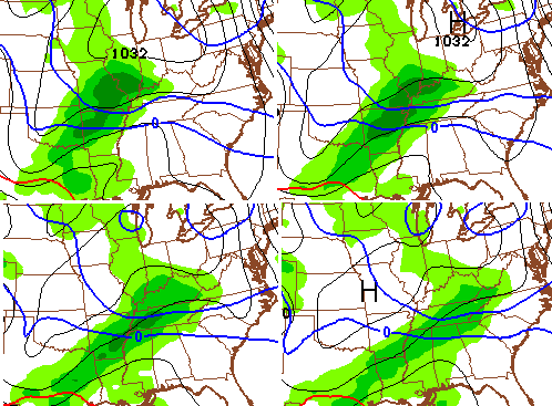
 The earlier run of the European Model is a little farther south with the heaviest snow…
The UKMET has a much stronger system that throws moisture farther north…

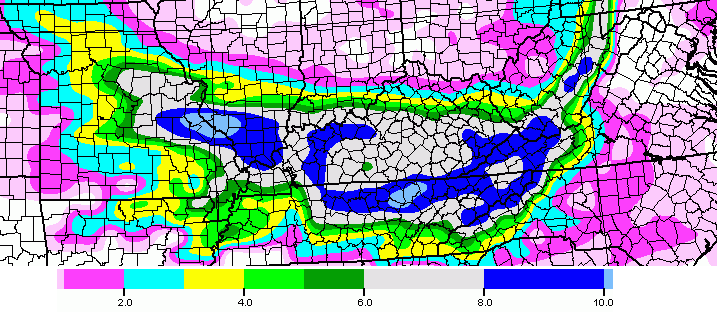
The WPC is highlighting areas along and south of Interstate 64 for the possibility of 4″ or more of snow…

I mentioned all the models, but the GFS are showing the Sunday night and Monday system. The GFS has nothing, but is trying to bring back the Tuesday and Wednesday system…
 Now do you see why I have been saying all week to wait until Friday night or Saturday to get a true idea of how this thing plays out? 😉
I will have a full update and a likely upgrade and likely first call late tonight. Enjoy the rest of your evening and take care.

Thanks
I once made the models do exactly what I wanted them to!!!! And I celebrated by walking my pet cobra on a leash through a wormhole to Planet Rolo!!!
To Bill Brasky!!!!!!!
This is awesome!
Either too high or too low for central KY. Always a bridesmaid never a bride.
parts of central KY was the bride earlier this season with 3+
some haven’t even had enough snow to equal an inch total. That would be people below the BubbaG river 😉
And I live just north of the Bubba River and I had 5-6 inches of snow. He is really serious when he says that is the cut off.
True stuff.
…concur…
Thanks Chris. I do not envy you your job! I will continue to hold out hope that we may see some real snow in Nelson County KY!
yeah this energy will finally arrived on land tomorrow morning. those model runs will be very interesting
Bring it North just a bit.
Central ky and northern kentucky had their show this winter.. looks like southern and southest ky will finally get their snow.. Sorry Central and northern kentucky..haha
I live in Louisville and I’m rooting for you guys down that way.
I would be satisfied with 2 to 4 inches here in the metro.
I hope you guys hit the bullseye.
Where I live in central ky we haven’t got anything close to a nice snow! Come north little by little plz!!
Let’s see what these models do…trust nothing yet folks!
Actually, northeast Kentucky has gotten zilch,
I hope we can get in on the 4+!
Nice write-up Chris. Thank you for including the GFS Model in this. Yeah, it is the out-to-lunch model, but it is our (U.S.) model. I am anxiously waiting to see if it springs back with the other models on the 00Z run. If the NAM continues its northward trend, one would think the GFS has to come back some as a part of the ensemble group. We shall see. Disclaimer: I could care whether it snows a flake or a foot. I am tired of the cold, but I love everything weather. As we say up in New York State; “I am a friggin weather geek”! Enjoy the storm everyone.
I am excited!!!! We have had a dusting here and a dusting there… Missed lots of school over little morning messes. I hope we finely get a few inches all at one time. That would be awesome !!!
I do dread these cd temps .
Sorry that should say cold temps .. ❄️❄️❄️⛄️⛄️⛄️
The NAM says BAM! We’re getting into that window where the NAM does good. Hope the 00z is good enough for Chris to upgrade to a WST.
Where??
Where what, Kat?
What does it say sorry, I’m in southern Indiana and have a lil one in head-start.
That run of the NAM only has the southern tip of Ind. in the several inch zone. Although the last two runs have been trending north, so need to watch next 2 or 3 runs.
Thank you
Go NORTH! Ashland/Huntington area needs at least one snowfall that amounts to something. Throw us a bone, Mother Nature! Thanks for your expert analysis, CB!
Agreed! Center this bad boy right on Boyd Co. & my house will be happy! 😉
I am in northeast ky and I’m rooting for yall in southern ky…but I’m telling ya, watch the northern trend closely
http://www.votersopinion.com/wp-content/uploads/2014/07/lucy1.jpg
She is waaaaiittiiinnnng! 😉
00Z NAM is running.
And???
Well, the new NAM basically lost the storm for Monday and has followed the GFS lead in trying to create one for the south on Wed. I think we may as well give up on the models this year and just wait until we can see whatever is going to happen with our eyes! NAM says no snow in central or east Ky.
Why is it the closer we get to the event that there is zero model consistency?
Actually Central KY should be thrilled right now. Virtually every storm the past 10 years has veered NW in the last 48 hours. Heavy snow for TN 48 hours out should put the I64 corridor in the sweet spot for this one.
The one time it doesn’t happen would be the time that it could put us in the sweet spot.
Thanks Chris for giving us the model runs and what they might possibly mean for those of us who are snow starved. Sometimes these models must seem like trying to read tea leaves. Anyway, let’s keep our fingers crossed and hope the snow dome cracks wide open.
What’s a good weather app to see these models
Looks like the GFS was on to something. NAM joins the GFS for a Dixie storm.
Chris just tweeted about a much bigger storm for tuesday
Is the cutoff low off the Baja going to come up and phase with the second piece of energy?
But that’s going to trend north, watch, just watch.
Notice he does not specify KY 😉 This stuff is most likely south as it has been showing. The big NW shift is what makes it over Tennessee. Seems an epic shift north to be over KY beyond a light snow for all but very south KY.
Seems a contradiction: On the TV just now CB literally said “a little bit more energy to work with on Tuesday”. This differs greatly with what CB tweeted saying much bigger system for Tuesday.
Which is it? Not an accusation, but a genuine question. Probably no harm no foul since most of the action should be south of most of us.
It would take a huge jog to the north to bring KY back into the game. But we first have to wait and see what tonight’s runs say.
00Z NAM says goodbye big snow for KY Sunday night. GFS wins… again.
And since the first wave Sunday night looks to be a dud, let’s see if the second wave can develop faster and move more north mid-week. That is KY’s best chance for heavy precip. Btw, heavy precip of any form would be welcome. Been a very dry start to the year. Louisville already running over 3 inches behind on the year.
Apps see’s phasing out in the Baja..Could really get interesting now..Lookout Northward and warm nose trend
Maybe GFS is on to something? The 00z NAM has joined lunch with the GFS. Hopefully the 00z GFS and ECMWF trend north? If it doesn’t tonight, then might as well give up on the chance for the storm to jog back north into KY. NAM printing out 10″+ for Atlanta. 4-6″ for Birmingham, Alabama. ZERO snow from Somerset, through Lexington and Louisville. Depressing run especially for SKY and TN folks to see a storm that could pas-s to the south. Anxious to see the 00z GFS and ECMWF tonight. Still keeping fingers and toes crossed!
Oh, and if a storm is still non-existent for KY on the 00z runs, then CB will likely not upgrade to WST, at least for tonight.
I am respectfully surprised CB is even mentioning storm in his thoughts here. That is unless his market coverage is a lot further south 😉
Still have not seen the rationale to explain why these potential events would defy the average model trends and start an epic shift north.
I can’t wait to see youtube videos of Atlanta drivers trying to contend with 10″ of snow.
OMG, when are you people going to realize that we can literally guess the weather about as well as these pathetic models? It’s quite entertaining…. one model run we’re all giddy and the next model run we’re all down in the dumps. This is better than a soap opera. lol Lighten up people!
A model on its own is a crap shoot and cherry pick, but the average and the trend usually does tell us. In spite of the waffles, the overall trend is south, but some folks seem to latch on to the ones that fit what wanting to see.
Not even Rolo is selling tickets for the Rolocoaster on this coming stuff.
It’s the Nam folks..When are you ever going to learn it’s the little brother of the GFS..Not to taken seriously…Anyways i would think you would want a little more amped up solution the more north you go..
And the NAM past 24 hours should never be taken too seriously. Surprised CB has been hyping it today and talking about issuing a first call on a event 48+ hours away. After the runs tonight no first call will be needed. Well, maybe a first call for an inch or so in southwest KY!
I’m sick of this crap wanting Snow is not going to happen in Northern Kentucky I know Chris was right when he said don’t get excited but I did anyway so I say spring on Spring early I do love summer as well as I do winter snow
CB again mentioned storm in newest tweet, but hat could be just for a fraction south in the state.
Not seeing it north like this so would appreciate his insight and what part of Kentucky.
GFS Tad more amped and north.
folks we are at least 4 days away from any type of a potential for a big storm…..you need to wait at least another day to day and a half and then all models should start converging on a solution……the gfs in its last 2 or 3 runs has been slowly but surely trending back west and north……patience my fellow friends is the key word.
Still a decent hit for South Eastern Ky…Just a guess but if it shifts more North then probably mixing issues..Freezing #### may come back into play..
WBIR Knoxville in agreeance with Chris’ tweet concerning “potential significant” accumulation Tuesday…east TN and southern KY. We shall see.
WTVF Nashville is also leaning a bit more at a bigger Tuesday snow.
WTVF currently going with 1 to 2 inches snow for Sunday evening.
And to think that I had laughed off the GFS, like I often do. But as Troy said, we shall see…..
There’s more drama here than at a kardashian family reunion
“climatology”