Good Saturday and Happy Valentine’s Day. Our arctic front is poised to sweep across the bluegrass state today and is going to cause some issues. This opens up a rather wicked period of winter weather that is likely to carry us through February and into early March.
Let’s start this party with a breakdown of our nasty weekend…
– The arctic front arrives early this afternoon and it is hammering down from northwest to southeast. Temps ahead of this will spike on a gusty southwesterly wind.
– A piece of energy is diving in behind the front from the northwest and will create widespread snow showers and squalls. Travel issues are a good possibility across the entire state this afternoon into the evening with light accumulations likely. Lots of coatings to 1″ with locally higher amounts.
– That will be a powdery snow that will whip around and may create whiteout conditions at times.
– Wind gusts to 40mph will be very possible as the flakes fly and the temps tank.
– Thermometers will hit the single digits in some areas during the evening as wind chills drop below zero.
– Lows Sunday morning will drop into the single digits for all and a few spots could be close to zero. Wind chills of -10 or lower will also be possible. This will be comparable to the bitter cold wind chills from early January.
This bring us to the complicated, yet pretty simple forecast scenario from late Sunday through early next week. We have two systems the models are trying to key on. The first one Sunday night into Monday and another Tuesday and Wednesday.
The Sunday night one holds the key to the entire scenario. If this system develops into a snow maker across our region, the second one likely stays weaker and well to our south. If the Sunday night system is weak or doesn’t develop, the second system would then develop farther north and stronger, and impact our weather.
We now have a worldly battle of the computer forecast models going on. The American models like the GFS and NAM are now going toward the second scenario. Other models like the Canadian and European are all in on the Sunday night and Monday snow system.
European Model Snowfall
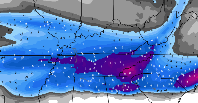 Canadian Model Snowfall

The GFS has only some very light snow across the far west and south Sunday night into Monday. That model is in the process of blowing the second system up and sending it much farther north and west compared to what it had been showing for Tuesday and Wednesday…
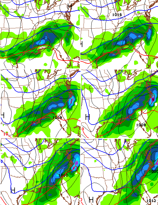
The UKMET offers a compromise of sorts as it brings a stronger system through here later Monday into Tuesday…
That scenario would actually result in the snowiest solution for the entire state.
To review… we have 3 different solutions on the table from Sunday night through Wednesday. Each solution would bring accumulating snows to Kentucky, but differ on where, how much and when to do it. Not one single solution brings anything other than snow. No rain or ice showing up on any of the models. That is a trend and one worth noting.
The bigger trend on which solution will verify is what should work itself out later today and tonight. I suspect a lot hinges on the New England blizzard over the next few days. How fast it moves will be a big factor in how things behind it play out.
Regardless of model solutions… all are going with another bitterly cold air mass by Wednesday and Thursday.
GFS

Canadian
Oh yeah… that shot may be followed up by another system by the end of the week into next weekend.
I just realized it’s after 2am and this is probably the longest post I’ve written in a long, long time. The things I do for you people. 😉
I will update things later today. For now, let’s track the wild stuff for later today…


Take care.

Ha. At least I’m not the only one up. Bring on the snow!
Been waiting for your latest update. Thanks for your generosity of time in sharing your latest thoughts with us starved snow lovers!!! Hope YOU have a good one and take care as well.
Thanks !!!
Well it looks like we have the cold air in place so whatever comes I think is going to cause some slick travel and it seems like you was going with Tuesday and Wednesday on us getting a lot of snow
Door #1, #2 or #3.. which one will it be?
I figure some snow out of sun nite and money. Not sure how much yet.
Seem more positive for this storm then any snow we had this year.. could this be feb 19th 2012 all over?
Hyped for the snow let’s hope it’s a good one. Only downside I may have to sleep at my office if it goes flippin’ crazy. Here’s to hopin it does. Cheers!!!!!!
Well my long post got deleted or didn’t show. I’m going with a blend of the UKMET and GFS. The other models do not look reasonable, IMO.
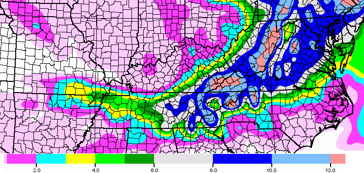
European with 9″ totals in Eastern NC, and Canadian with a sheared-out southern storm with almost a foot in AR.
Whoo hoo!!!
You are greatly appreciated Chris Bailey !!!
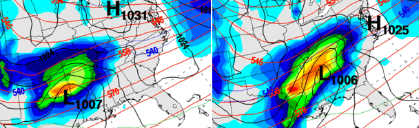
I can see why CB has written a long post. Most, if not, all are starting to jump on board with TWO winter storms to impact the region next week! Heck, the ECMWF is crancking out 40 inches plus and a widespread 3 feet of snow next week for Tennessee!!! I mean look at this map and tell me this is not a crazy run? Joe Bastardi actually pointed this out and said that the ECMWF was missing a key peice and that the next run would go bozonkers in the Tennessee Valley and up through New England. Now this is only ONE MODEL RUN, so take with a block of salt! http://pbs.twimg.com/media/B9zCqpoIMAEtB1i.jpg
This is map for both storms combined together!
Yeah if that much snow fell in TN, I think more than a block of salt would be needed. 🙂
Yep..I’m ready for it here in east tn!!!
Wow…and if they both pull north…ha ha
Thank u for all your hard work chris. You r the best choice to get our weather information!!
Thank you Chris for all your hard work and dedication
We are very blessed to have you here.!
🙂
Get some much deserved rest!
Accuweather has flurries for Corbin Monday, really hope we can slide into that heavier snow. Going to be a very sharp cutoff, here is SE KY.
Why bother with accuweather? They never have it correct
Thank you for the updates, we appreciate all of them.
Here in Northern Lawrence County the sky looks super thick with moisture, but absolutely nothing falling from it.
I have a feeling behind door #1, #2 and #3 is Lucy smiling at us in cky
I know what CB means, but this seems a very long and gracefully articulated met way of saying this thing is dynamic and I do not really know what is going to happen yet 😉
Still at this time seems to be a south system and folks are trying to will it and interpret based on the waffle direction that favors north. Lucy might break records with these next coming days.
Looks like the Ohio River counties are out of luck on this one. Hope you enjoy your snow Southern Kentuckiers.
Optimistic me hopes for a last minute northern push to get Louisville at least some festive flakes.
Thanks for the update CB. Stay warm fellow KWC friends.
As far as main action, it would seem you have to go down to the Kentucky welcome signs on the south border to be in the main action. Even then as CB noted that presumes the systems flow as he suggested.
SE KY would seem to have a good shot compared to the rest of Kentucky. After all the waffling over the last few days, still seems south, but you never know until the snow.
…we will need that north push as it seems that we have been left in the nothing to dusting category on the runs today…sad..
Long time follower, first time to comment. Just wanted to say thank you Chris for all of your hard work. It is greatly appreciated! With that said, I live in snow-starved South Central KY…so I say BRING IT to the snow!!!!
Thank you Chris for all your hardwork. I love checking out the weather everyday on this blog. Let’s hope we get the snowiest scenario!!!!! I would love to have enough snow to go sledding with my girls and build a snowman!!!! Let it snow!!!!!!!!
I don’t post comments very often but I just want to say Thanks to you Chris Bailey for your dedication to this weather blog. Let’s hope we get some decent snow to coincide with the cold temps, eh?
Canada is probably too far north 😉
Glad I held off on kicking the football on this one
Yet efforts to spot the ball continue 🙂
WINTER STORM WATCHES HAVE BEEN POSTED FOR PARTS OF TEXAS,OKLAHOMA ARK. WEST TENN. SOUTHERN TENN. MISS. ALABAMA.!! ……I’m getting ready for it here in east tn…
Looks like East tenn. is in a good spot right now..Early morning run of the GFS ticked a little Southeast..Nam is really trying to blow this up big time..Warmer air keeps going further north on the Nam..
Makes sense.
Thanks for your time and effort Chris, it’s very much appreciated. However, I feel that Lucy is getting ready to perform her usual antics. haha
At least for everyone except east Tennessee…. Think I’ll head to Knoxville tomorrow!
Back in April 1987, a storm system similar to this one showed up on models, most stations were reporting a chance for a wet snowflake, however a new station(TWC), before they went bonkers on the global warming bandwagon, reported some models showing 3 feet of snow. Everyone said that can’t happen, but it did, I measured exactly 36″ of snow in Pike County. So, maybe 28 years later, it could happen again.
Yes, that was April 3 1987. I was too young to remember much but it’s still fascinating to read about this storm. Even parts of northern Alabama had close to 10 inches; Birmingham got their latest measurable snow on record, it became known as the Dogwood Snow.
This happened exactly 13 years after the so-called Super Outbreak of tornadoes in 1974.
Festive flakes on the way for the Metro. Meh
Does it look like East TN will get any snow?
We are in a very favorable spot right now Mae..if the trend continues I see winter storm watches going up for our area late today or tonight! For Monday…
I’m ready for it down here in Sevier!
Thank you so much blizzardtim. Would appreciate it if you would keep posting for our area if you have time. I can’t read these things that Chris put out, but I always read this blog. Once again thanks for answering my post.
Not problem..as of now anyways looks like accumulating snow is likely in our area
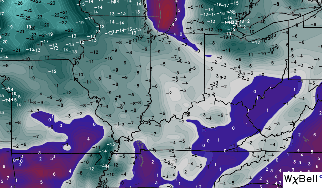
The upper level feature coming in behind the front this afternoon
is looking like few hour period of snow for 64 south..
Thank you Chris for all that you do for is. Your site is the first thing I read every day. Thank’s for the update my friend.
Agreed. It would be nice though for CB to have a bigger snow to talk about beyond a small fraction of his met coverage area. Not seeing that happen for this, but never know until the snow.
Thank you Chris for all the extra time you put in to keep us informed. Like I said yesterday these models are as easy to read as tea leaves. Anyway, I wished for a Valentine snow and I hope we get it. Hope everyone stays safe and has a wonderful Valentine’s Day.
Keep your updates coming and don’t forget about us here in the tn border counties. The lex and Knoxville stations leave us in the dark a lot … I depend on your forecasts 🙂 Think snow !!!
Not true. Knoxville stations always inclue the Middlesboro and southern KY region.
Lord help this blog from the backlash if all this ends in naught.
Of the few events so far, this seems the least of one to expect to hit beyond far south and has shown as such since Thursday night. Waffles and all. The only time this event was showing KY as the sweet spot was seven days out like they nearly always do.
Looked like the Sunday night system was weak..But the second system phased and was more south?..Figured it would be more North and west..Oh well it’s the Nam anyways..Maybe a clearer picture tonight..
I’m loving the NAM run. Big hit for my area.
so i guess no upgrade? I guess that says a lot in itself
Thanks for the updates Chris, always appreciate your thoughts
I’m so thrilled this snow storm is gong south. Tennessee can have and keep the storm. I’ve been praying hard to keep the snow away . Congratulations Tennessee
12z NAM showing significant snowfall for east tn..
nobody cares bout Tenn Tim.lol olny good thing bout Tenn is KEN MELLONS
Speak for yourself Rolo. 😉
Now rolo..you know you miss me..I can’t help I’ve got great powers with the snow mixer!!…lol..lol!
Spitting snow in Knox county
Just going by the GFS that went down hill fast..lol..what a model
Never trust 6 or 18z runs. They are just guessing cuz instruments are only sent up reading data in atmosphere twice daily. Only on 12z and 0 z runs. I’m betting 12 z today moves back north. Or should I say hoping! Lol
No upgrade …. So sad. We never get snow.
Thank you so much Chris for your devotion and time you give us so freely all the time!!!! You truly care and that is why your blog is the biggest and the best place to check out what is going on with the weather!!!! HAPPY VALENTINE’S DAY….stay safe and warm!!!
Let’s be honest, this will move north. It’s done it all season. For once though, the models have had this storm farther south longer. Just got a feeling most of Kentucky gets a good snow! At least I hope so.
Go Cats!!
It needs to go north for most of Tennessee to be the sweet spot. I think that is a main point here. Would need to be a mega epic north shift to make Kentucky that and the cold air is in place unlike the other events that did move north.
Seems too much against it happening, but can’t stop folks wanting to take a good kick 🙂 Never know until the snow. That is my new reluctant motto.
Bang on the drums, Bubba. I can hear them clear down here.
As far as most of Kentucky, I am not sure what drum there is to beat in regards to a bigger snow. Expectations seem off IMO and I do not see model info to support the expectations. Am I missing something as far as this being mainly a southerly event?
I am wondering the same thing. Define “event.” Chris specifically said in his post earlier that all three solutions bring accumulating snow to Kentucky, but differ on where, when and how much.
Unless I’m reading wrong, it seems as though you’re stating nobody in the state is going to see snow worth mentioning. Or are you just on the lookout for snow over 6 inches? Or maybe this last post was one of those “read between the lines” posts. Even the NWS in the latest winter storm watch for TN has 2-4″ for them–and that’s because their criteria for winter storm warnings is lower than ours.
I also do not know how expectations can be off when you don’t know what to expect. The folks in TN expect a “big snow?” Why?
Other than a few model runs, what do they have? Guess I better be careful in case it irks that someone else gets their beloved snow thrown into question. The shoe feels differently when it’s on the other foot.
Nothing of note predicted in the tri-state Hunt/Ashland area. After today’s non-exempt dusting only light mix/flurries predicted on Tuesday. More of the same dry wasted cold, so cruel now we lose out to Alabama for a snowstorm, spring can’t come fast enough.
I’m in Flatwoods, KY. Radar is lit up but nothing but wind. We need a big North shift to get anything… 🙁
Non-event that is.
Im still thinking the 12z GFS is in La La land to a point
…WIND CHILL ADVISORY IN EFFECT FROM 3 AM TO 9 AM CST SUNDAY… …WINTER STORM WATCH IN EFFECT FROM SUNDAY EVENING THROUGH MONDAY EVENING… THE NATIONAL WEATHER SERVICE IN NASHVILLE HAS ISSUED A WIND CHILL ADVISORY…WHICH IS IN EFFECT FROM 3 AM TO 9 AM CST SUNDAY. A WINTER STORM WATCH HAS ALSO BEEN ISSUED. THIS WINTER STORM WATCH IS IN EFFECT FROM SUNDAY EVENING THROUGH MONDAY EVENING. * TIMING…BELOW ZERO WIND CHILLS SUNDAY MORNING…SNOW ACCUMULATIONS SUNDAY NIGHT THROUGH MONDAY NIGHT. * ACCUMULATIONS…2 TO 4 INCHES OF SNOW…WITH LOCALLY HIGHER AMOUNTS POSSIBLE. * WIND CHILL VALUES…FROM ZERO TO 10 BELOW ZERO. * MAIN IMPACT…VERY COLD WIND CHILLS MAY LEAD TO FROSTBITE ON UNPROTECTED SKIN. ACCUMULATING SNOW MAY CAUSE HAZARDOUS TRAVEL CONDITIONS ACROSS THE AREA. * OTHER IMPACTS…SLIGHT CHANCES FOR SLEET AND/OR FREEZING RAIN MAY MIX IN WITH THE SNOW MAINLY SOUTH OF INTERSTATE 40 AND WEST OF INTERSTATE 65 SUNDAY NIGHT INTO THE DAY MONDAY. CHANCES FOR LIGHT SNOW MAY LINGER INTO TUESDAY…ESPECIALLY FOR AREAS NEAR THE CUMBERLAND PLATEAU.
nd here comes my winter storm watch!!!
Tennessee truly deserves a good snow as it has been without one for MANY years. Hope TN as well as my area on the TN border gets a good thumping but don’t be that guy…..the one that is rubbing it in everyone else’s face who won’t be getting one. 😉
I think Tim is trying to stir the pot and throw the fact he’s going get a big snow in Tennessee …hahahah.. I for one don’t want the snow.. Tim, you can keep it 🙂 Congratulations Tim
Yeah..haven’t had any snow This year..getting excited..not trying to rub it in…just feeling like a 5,year old in a candy store right now…
So much for today’s snow, sun now out in Hunt. WV.
boy the tenn. people are coming outta the woodwork today lol
There hasn’t been a reason for us to say anything before now, haha
Moved down here 2 years ago…and boy it can be rough on a snowlover…
hopefully u guys get what ur looking for
I really do hope you guys get your snow. I just hope mother nature can share. If I didn’t have to go out of town to go to work, I wouldn’t see snow. Lexington got 5″ a couple of weeks ago. Nasty on the roads. Back home in Richmond I think we got 5 flakes. Thank goodness I did at least get to see some snow this winter.
I’m glad the folks in TN are in line for a good one, living in Monticello I can feel their pain. I’m still hopeful we can squeeze a couple inches out of it!
Congrats Tennessee! I would rather you guys get snow than Ohio and Indiana again.
No big snow for kentucky… Yippie..haha
Surprised CB has not clarified so expectations are not off around here. Maybe CB has information that suggests to continue the impression of a chance?
Again, I refer to Kentucky being more the sweet spot rather than the far south.
I think u r correct sir….the north shift cant be ignored…but usually the trends/shifts always work against us …this would actually be great , so prob wont happen lol
Central KY is not a sweet spot, more like a sour note. Like lemons mixed with baking soda.
Are you waiting for him to say “this is not going to be a big snow for Kentucky?” If those are the words to “temper” expectations, he can say it right now. I’m not expecting three feet of snow or even three inches. Although one’s a whole heck of a lot easier to obtain than the other.
Sleeting in Burgin.. it has Ben doing this for like 30 to 45 minutes now.
Snowing sideways here in east Louisville.
I can sense the blog is getting a little restless waiting for the midday update from CB
Lol yes I am.
Chris just tweeted the European showing a healthy snow for much of kentucky monday
@Kentuckyweather: The European Model is farther north and stronger with the low across the south. Throws snow as far north as Indy and Columbus. #kywx
http://i.imgur.com/EM3fclZ.jpg
Wow! If that verifies we will ALL need shovels!
It is pouring the snow in greenup
Someone post a link to the Euro. I wanna see how healthy.
Cherry picking time 🙂
Seems like most of the models other than the GFS are coming around towards a healthy snow. As of right now the GFS looks to be the lonely cherry.
Guessing we get an update after UK plays. Patience, everyone 🙂 and go big blue!
Based on CBs conditions posted, that should mean the second system would be mainly south of KY.
I will trust CBs word here over my own model reading 🙂 😉
Just would like his thoughts to bridge my perception that could be right or wrong.
Guess the kentucky snow lovers are back on top of the crazy snow roller coaster. LOL
Shows up to 24 inches in southern ky, but I’m telling ya, the northern trend is STRONG
100+ comments on a toe biter of a storm.
Well I do have some big toes.
101 now, with yours.
well SE KY LONDON north to Richmond then east SE in for a good snow will be sharp cutoff in the north, but the deprived SE KY folks fixing get there snow. fact is MOST weather folk STILL don’t have clue of path ETC, I would hope CB comes with a STAND ob forcast by tonite run. fact is the Athmosphere is right and there going be a surprise as we get into Sunday/Monday runs a surprise to the good for KY snow luvers.
couple weeks ago we had a chance but as it develop it moVINDY was expecting 8 plus inches, it move futher north they got nothing. so go get ur popcorn,ur bread and milk cause this early week not going be a ankle biter, but will be a giraffe hunger!!!!!!!!!!!!!!!!!
Light sleet falling in Berea.
“snow don’t be bouncin’ off yur car hood and stuff like dat”, as the man at Wal-mart said earlier.
OMG look at the Euro model and it’s 48 hrs out!!! Take a deep breath Mark……Inhale……exhale……..slowly
Is there a site for the Euro snowfall map? Would like to see it.
Randy posted a link to it a few comments above this one.
http://i.imgur.com/EM3fclZ.jpg
Thanks guys! Appreciate it!
Are you in Lexington MarkLex? How much is it showing for Lex. At this time?
It looks like north part of Lex 9.5 inches and south part 12 inches. I mean, it may not happen, but it’s fun to look at when where that close to the storm. That’s usually eye candy we see 7 days out, never 2 days out!
Not happening
Have faith bud lol
You may be right, but you may be wrong……XD
I will say…someone asked Bailey on twitter if he believed the new euro….his response “gulp…yes”.
Did someone say snow? 🙂
Yeah it’s not entirely likely we get the huge amounts on the latest Euro, but it’s looking more and more likely that we will see a significant snowfall over a large area. Most of the time this year we have had models show a huge snow 5 or so days out and we had to hope for a correction 48 hours out. This time it just feels different where 48 hours out it is showing us under the heaviest snowfall.
Hoping for Rolo’s giraffe hugger… Lol.