Good Saturday afternoon, gang. Our arctic front is rolling across the bluegrass state with 40mph wind gusts and snow squalls that are putting down light accumulations. Blowing snow will increase as our temperatures rapidly decrease. Wind chills go well below zero. Basically, I have no changes to the forecast for tonight and Sunday morning.
Looking toward Sunday night into early next week… I have decided to go ahead and upgrade to a Winter Storm THREAT for the potential of 4″ or more of snow. A THREAT highlights the potential and if confidence increases… it will be upgraded to an ALERT. If confidence decreases… we would downgrade to a smaller event.
My confidence in snow for Monday is actually pretty high. The placement on where the heaviest snow will fall isn’t as high. The GFS and NAM continue to highlight western and southern parts of the region for the best chance at accumulating snow. The new European Model is in and is a big hit for the entire state…
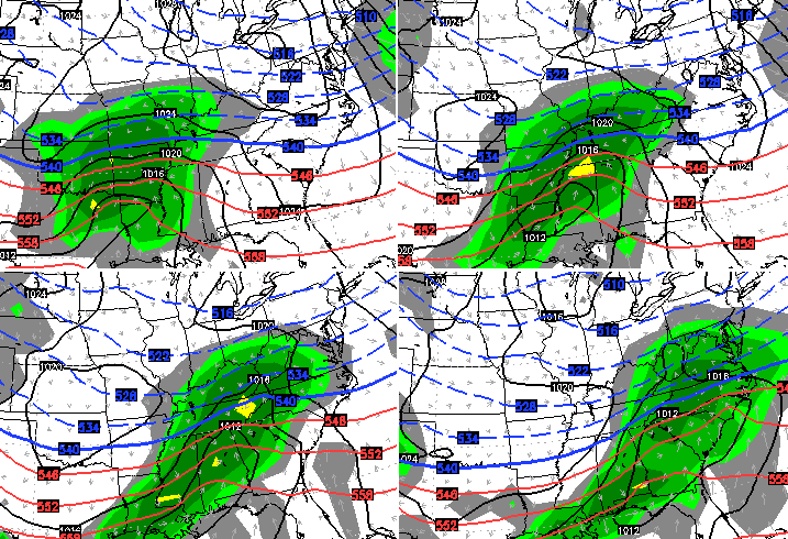
 Is that right? Well, we are within 48 hours of this system happening and it does have support from the UKMET…
So, I have seen enough to certainly warrant upgrading to a Winter Storm THREAT. As I mentioned, this could be upgraded to an Alert or downgraded depending on what I see later today and Sunday. As of now… it’s an increasing potential for a decent snowfall for, at least, parts of Kentucky.
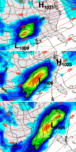
As that storm moves away… it allows for another strong arctic front to move through here on Wednesday. That looks to have a period of accumulating snow with it. The coldest air of the winter, so far, will follow this up by the middle and end of the week. This map looks very much like what we had during some of those brutally cold periods from last winter…

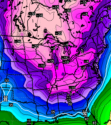 Below zero temps are a good possibility later in the week… and on more than one day. Wind chills could be deep into the danger category. Brutal.
I will update things again later this evening. Here are your squall and arctic cold tracking tools…


Hamburg Area from WKYT Studio
Lexington
I-75 @ Winchester Road Lexington
US 60 @ US 127 Frankfort

US 127 @ Frankfort Frankfort

US 60 @ US 460
Frankfort

I-75 MP 127
Georgetown
I-64 MP 97
Winchester
I-71/I-75 at I-275
Near Covington

I-275 at Mineola Pike
Near Covington

I-275 approaching KY 20/Airport
Near Covington

Bluegrass Parkway Bardstown

I-65 MP 32

Downtown Louisville @ 2nd & Broadway
Louisville

I-64 @ I-264
Louisville

I-264 @ Freedom Way
Near Louisville International Airport

I-75 at MP 36
London

I-75 at MP 23
Corbin

Enjoy the afternoon and take care.

This is good for the snow lovers…. Idk about these crazy cold Temps though…
Bring it!
Omg I hope this verifies. Think snow! We all deserve a good one.
I personally hope we don’t receive that much snow. My father has a bad heart and lives way out in the country, on a road that never melts or gets graded. I worry about him and other that have health issues. Especially those on oxygen. With heavy snow comes the greater chance of losing power. Heavy snow storms do make it harder to get medical attention if needed. But with that said, hope all has a great day. GO CATS
I I hope we don’t either because I have blood pressure issues and panic attacks.I don’t need this kind of news.
John Belskis confidence is still low on Louisville area getting accumulating snow.
http://m.wlky.com/weather/Accumulating-snow-chances-remain-on-the-low-side/31273928
I hope we get a North trend
on 18z run.
I want everybody down south to get thump.
I just want A 3to5 inch snow.
18z NAM coming north now….uh-oh Mr. Belskis lol.
NOT surprised by this. Isn’t the trend, the rule until broken. Just because it happens to be our friend this time around doesn’t mean we discount it people. 🙂
marvelous news
if the Gfs excepts the northern Trend
then I’m all in.
do not worry about John Belski you know my man is rooting harder than anybody for significant accumulation of snow in Louisville.
so if this happens Sunday night and Monday ….does that mean the Tuesday and Wednesday storm stays south?
are the models shown above for Sunday night into monday, or monday day?
Sunday night / Monday
Temp is at 39 flurries out with a DP of 25. If the air wasn’t so dry we could have had measureable snow in Knox by now.
I seem to remember systems where the air was so dry that it took hours of saturation to get the snow to hit the ground. Hope this isn’t one if the deals!
Rodger remembers those types of “storms” all too well. Yep, sometimes the warm air pushes the cold out of the way and KY gets rain and sometimes the air is too cold and dry and shoves the precip south … the dreaded “virga storm.”
It really is a wonder given how many factors need to come together that KY ever gets a big snow.
So says Rodger in Dodger!
Are you getting snow andy? Snowing here in clay. Sticking in spots of yard but not real bad just yet
southern ky may finally get something bigger then covering monday. I feel more postive then any system we had so far this winter.
there has been flurries since about 10:30 or so. Its snowing lightly atm but no where close to sticking
Snowing in Pikeville. Happy Valentines day everyone.
It has been snowing hard for the past couple hours here in greenup
It’s snowing in Winchester
I hope with everyone else we finally. Finally get a decent snow. This has been a SORRY winter. But it looks as though the wait will be worth it. Please Good Lord allow us a good snow to play in and enjoy on the long week end monday. I have as much snow right now on the ground as I ve had this winter in Lee co. and that ain’t saying much. THANKS Chris for all your work and keeping us posted protecting our saftey.
sleet/snow all melting to leave wet roads that will be flash freezing later today. Good luck out there tonight, you’ll need it.
Sounds like we may actually get some SNOW!!!!! Can’t wait to see next update from Chris. Don’t keep us in suspense to long Chris all us snow lovers have had our prayers answered. Snowing right now in Clay County, sticking some.
As much snow on the ground as we’ve had all year in Carrie, may get an inch out of today
In Lexington….aaaand its gone….
OLD SCOoL WArning!!!!!!!!!!
Soon to be followed with “move along folks nothing to see here”.
I thought Rolo would resist riding the Rolocoaster for this, but the temptation was too great. CB pushed him over the edge and the ride begins!
18z NAM IS coming in..and its singing A very snowy song up to 42 hrs.
I hear for most of kentucky as well!
Can someone post a link to nam?
http://mag.ncep.noaa.gov/model-guidance-model-parameter.php?group=Model%20Guidance&model=NAM&area=NAMER&ps=model
You can watch the run of it there.
http://wxcaster.com/models_main.htm
When it’s finished you can see the possible snow amounts there.
I can’t find it on those links
Nvm
Still 51 degrees in Nashville. That obviously won’t last much longer 😉 . Winds just now starting to pick up. Much of central Tennessee under Wind Chill Advisory for very early Sunday and then a Winter Storm Watch for late Sunday into Monday.
The wife and I have already made the dash to the supermarket 😉 .
Chris, or anyone
If this storm does verify and we are in a good spot, do we in fact need to worry about virga or verga (I forget how it’s spelled)
Thanks 😀
Lucy says: Business is really good 🙂
It’s a possibility the air will be pretty dry cause of the artic air. Might take a little time for the atmosphere to moisten up. Further south you go that will likely be not a issue.
being on the edge of the precip shield you always will deal with virga
Be very careful how you spell it!
Is that the sun shining at 2nd and Broadway in Louisville?
Entire stat of tn. Under a winter storm watch!! Wow.
Hoping SOMERSET gets some, let’s play in the snow, snow. Chris is SUNDAY it, or can we hope for more WEDNESDAY. Greedy? Yep I am.
Wow, that was insane!!! Just experienced blizzard conditions. Wind gusts were 40mph and a complete white out with nearly ZERO visibility. Snow accumulated to an inch in about FIFTEEN MINUTES!!! That’s 4″ an hour rate!!! All roads became wet to snow covered in 5 minutes and when mini blizzard stopped, 5 minutes later the sun came out and has been melting the snow on roads but sidewalks have melted and refroze so now my driveway and sidewalk is a slippery sheet of ice! Hopefully winds dry the roads up before they go below freezing tonight. Oh, and winds are extremely gusty and blowing snow creating pico to micro blizzards.
That same thing happened here in Floyd Co. along with thunder!
Winter Storm Watch issued for West KY for “Significant Snowfall”
Bread and milk warning! Oh, and chili fixings too!
If you want a good website to look at the GFS and NAM models, go to coolwx.com
Winter Storm Watch issued for southern KY. Jackson mentioning 4 plus inches likely
Anymore updates on the 1800 NAM precipitation total forecast for Sunday night/Monday. And if there is a North shift
And what that means for Lexington please
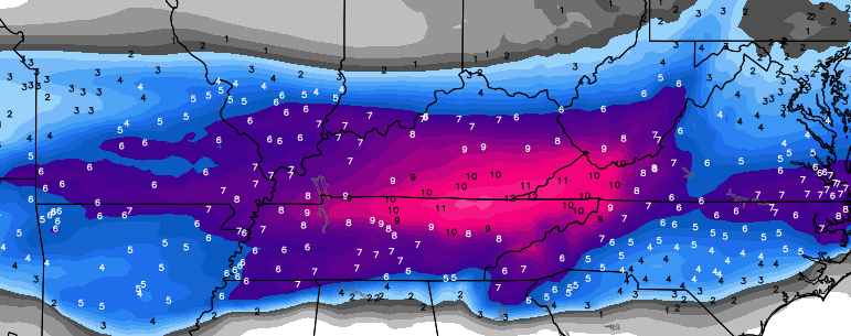
18z NAM looked to be around 1-3″ for Louisville to Lexington. Huge hit for around Middlesboro, around 10-12″. 8-10″ for most of southern Kentucky, 3-6″ for most of central and eastern Kentucky. 6-10″ for the counties that border Virginia.
No clue about Lexington, but currently central ky looks to be in the cutoff area. Southern ky and into tn look good for snow
It will tend more north…at least some, if stronger
Nope, arctic air will suppress track I bet
For those of us in the Charleston WV forecast zone. They have No precip predicted after tonight until next Friday. Looks like we are doomed again. Hopefully it is just another case where they are extremely slow to respond.
Say hi to Lucy for me folks
Well this might be the best shot at getting a good snow down in these parts in some time
I hope it really happens but i’m not betting on it
Gfs more north with the snow
Gfs more wide spread with moisture. Best snows in tn and southern counties, but a nice snow for nearly the whole state including Lou, lex, etc… 6 inches in central ky, maybe 10 inches in the southern counties.
Will have to watch overnight runs to see if the trend is still north
Also, take note im not sure if models are taking this into account. The snow ratios will be higher due to more of a dry powdery snow and not our usual wet sticky snow.
GFS snow map? Anyone?
Not out yet, probably will be close to 6.
OLD SCHOOL WARNING!!!!
Hide yo kids, hide yo goats.
NWS mentioning the possibility of extending the WSW a couple of counties north in the Jackson area. So counties like Rockcastle, Jackson and Owsley might go under.
Now a Winter Storm Watch for many KY counties on/close to the TN line. Bowling Green and Somerset included. As mentioned before, all of Tennessee under a WSW. Speaking of Bowling Green, they earlier had blowing snow while Nashville was in the 50s.
Interesting that – as noted above – the most recent GFS is tracking the heaviest snow a bit farther north.