Good evening, folks. Our Valentine’s Day is just flat out nasty for much of the bluegrass state. We’ve had snow showers and squalls covering roads, winds gusting to 45mph with crashing temperatures. The thundersnow potential I talked about several days ago verified in eastern Kentucky.
Bitterly cold temps with dangerous wind chills settle in this evening into tonight. Single digit lows with wind chills approaching -10 will be common.
Now it’s time to focus on our Winter Storm THREAT for Sunday night and Monday. This will likely be upgraded to an ALERT tonight as I’m feeling pretty good about the prospects of significant snows. Figuring out where the heaviest snow falls will be the issue I will have to tackle.
The NWS has issued a Winter Storm Watch for western and southern Kentucky…

I will state right off the bat, I don’t think those come far enough north. I would have issued them all the way to Interstate 64 to be honest and then adjust once you upgrade to warnings or advisories. This seems to be an increasing theme with the NWS folks to piecemeal watches and advisories by starting with a few counties then adding a few more with each update. How about we start with more counties then fine tune when the warnings are issued? It’s a much better concept because it raises awareness much, much more. Oh and we are talking about a watch not a warning.
Instead, my twitter timeline has been flooded with ” so it’s not hitting Liberty?… so it’s not going to snow in Richmond?…. so it’s all missing (fill in the blank) to the south?.
Severe thunderstorm and tornado watches always allow plenty of extra room… why not do the same with winter weather products? Rant over. 🙂
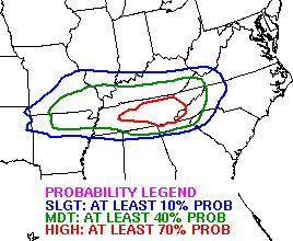
The latest from the Weather Prediction Center has much of the state in a slight risk for 4″+ snows and even has a moderate risk for a lot of folks…
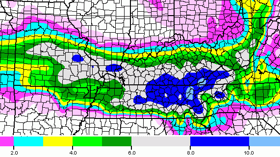
 The NAM and GFS runs from late this afternoon are strongly trending toward the snowier and more northward solution of the European Model.
GFS snowfall…
NAM snowfall…
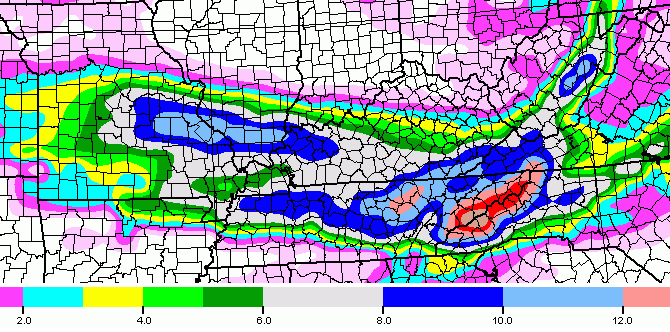
Again… both models continue to trend toward what this morning’s European Model was showing…
Bitterly cold air will follow that up for the middle and end of next week. Record cold temps may go way below zero with dangerous cold temps possible.
I may update again later this evening. Take care.

BAM!!! Bust that dome
Not too sure 4″ busts the dome, but at least covers it 😉
Aren’t you in Madison Co.? Why select the model with the least amount of snow? 6″-8″ in the other 2 models. Think positive, THINK SNOW
I take the average of the models and the reality they are at best 50% of the totals usually for the maps for Richmond.
If they say 6-8, it is near certain to be 3-4. If had a Men in Black pen to stare at I would be set 😉
I’m sitting between 8 and 12 in all three models. A 10 inch snow would be double anything that we have seen in a decade plus. Will probably end up with three or four. lol
more like a dusting to 1 inch 😉
I’m still very weary of this setup but it is somewhat encouraging.
1st time this season the road has been covered by something other than salt.
1st Alert of the year? I’m hoping for a North trend and Lex getting in on the act
“Like”
Still seems the main stuff is around the border area on down and a few inches above that. Sticking to my not-worth-much-guns here. Talked too much smack to deviate now 🙂
Still think Tennessee is going to get smacked real hard, but been saying that like a looping replay. It would be cool being stuck in a cabin in the Smokies. With lots of chow, drinks and a fireplace 🙂 Would be pretty lame if stuck up there without that stuff.
Please let it come to Mercer County !!!!
Laurel County 10 inches….RUN TO KROGER! Just grab anything…prepare! Sorry, just getting excited.
Don’t run to the grocery stores that’s just plain nuts! Lol
Kroger approves of this message 🙂
Next weekend looks like the same setup..can we get two in a row?..
7 days away. I doubt it. Besides technically nobodys got the first one yet.
Models had the potential for this system pegged 12 days out..Chris only mentioned it when it was still showing up 6-7 days ago..May or may not get something next week but at least something is showing up..Less than 36 hrs out the models would have to do a complete 360 for no one to get snow..Southern counties 6-10
🙁 Boyd Co. never gets nothin’.
I feel your pain.
Me too near Huntington WV
u not get nothing today jimbo?
Im not to sure if models are taking into account that the snow ratios will be higher given the dry powdery snow its not our usual wet sticky snow. Interested to see if the northern jog will continue???
I keep thinking of that post you had when someone asked what influences the low. It was one of the greatest replies and this may be the case again.
I keep thinking of that post you had when someone asked what influences the low. It was one of the greatest replies and this may be the case again.
Its the truth lol
“climatology” !
Nice to see it come back to around the 4-8″ for Bardstown (along the Pkwy’s) instead of the piddly “paw-nipper” earlier. I’ll believe it when I look out the doors/windows. It was bad enough to see heavy snow bands coming towards Bardstown/Nelson Co. earlier, then see the “big hole” surrounding us just before it got here (grauple or whatever for a time, then sun…..
Ho-Hummmm……………..{{yawn-wake me up if we get anything….}}
Since the maps show Richmond out of the main action for all the maps and getting mainly leftovers, the maps at least fit past maps and results. Does not matter where the system is coming from. Winning! 🙂 😉
I I live in southern Ohio and we have missed every storm & looks like the same for this one. But instead of north it’s south of me… Smh!
It seems that as of now, Ashland/Catlettsburgl line or bubble is getting nothing more than a dusting if that. We have the wind though!! I am still holding on to the possibility of a northern shift. Stranger things have happened!! Thanks Chris for keeping us up to date!!
Finger crossed!
And everyone in Lex and Richmond and Ashland are ecstatic for the Fine Folk of Southern Kentucky…..who have not seen snow worth anything since 1998….:-D
Right?…..Right?
does the trend to the north continue? in the famous words of the great philosopher Daniel Bryan….YES! YES! YES!
OLD SCHOOL WARNING!!!
We are on the upward direction of the Rolocoaster!
still in the station here. The roads are getting crunchy though
most every storm this season trends even farther north as it rolls out!!!
Rolo has made an old school call. Mark it down, this thing is happening. What’s your call for Clay/Knox Rolo?
I would if this was his first call and not his 100th for an old school that never transpired.
Lol. Rolo not made old school all year. (Well, maybe only a couple times ). Much less than years past.
Same results though: Up, down, up, down 😉
Should make my run down to Nashville fun Monday morning.
I see this this thing continuing to head north with around 8″ of snow in Lexington❄️❄️❄️⛄️⛄️⛄️❄️
Did your snores wake you from your dream? 🙂
* minus 1 this
I don’t know what to think in Hunt/Ashland area models look like we might have chance at something. But Charleston NWS and local tv no mention, maybe just wait and see.
nothing today for u jimbo? we r getting hammered as I type this
So this is for Sunday Night/ Monday. I guess the first wave is back. Just last night the first wave had disappeared and everyone was thinking this meant the 2nd wave had chance to trend north since weaker first wave. Now the models have the first wave again and showing it pretty strong. So confusing!!
hard to keep up sometimes lol things change quickly , normally for the bad though…bad meaning no snow
southern Kentucky is LONG overdue for a big un
Bubba
all you need is a 52to75 mile jog from the low towards the north and you will receive your long waited dome buster.
Not seeing it, but also not wanting to shovel my drive to get out a so win for me 🙂 The snow lost its magic to me with my kids in their late teen years. It was truly all about them. Not the same now.
My fixation is the constant models misses. The data forecaster in me is continually intrigued.
If you go by the blend of the Euro/GFS/NAM, areas like Knox county, Laurel County, Clay stand to pick up 6-8″ of snow.
Looking at the totals from all 3 maps Knox could get 8-12 IF taken verbatim
The little girl spotting the football approves 😉
is hart county ky getting any snow
Looks like 7″-9″ in Gart Co
Here in my neck of the woods we received some white stuff today, more than festive flakes & at times a near white out. Was hoping for a few inches but this Valentine’s afternoon the ground was white. Considering the few puny little dustings we have had, I guess today wasn’t a total bust. I’m gonna keep looking for the dome buster. I still think we will see it soon.
thanks
Perfect placement 36 hours out for a snow drought buster in Lexington. How many times in the past 5-10 years have the maps showed Lexington at 6″ plus 1 day or 2 out only to see it happen in Dayton or Indy? A dozen at least.
And the Louisville heat dome continues even in sub-zero wind chills. It looks like a dusting.
Part of my woods were under winter storm watch and there are really high that this will break our depth snow drought.
when will the snow move in to hart co ky
Not any snow to speak of, but the wind is as bad as I have heard in years. It is dangerously cold outside!
From NWS Memphis. Gawd:
IN THE
END SOME AREAS SOUTH COULD PICK UP A HALF INCH OF FREEZING
RAIN…MIDDLE SECTIONS AN INCH OF SLEET…AND TO THE NORTH UP TO
EIGHT INCHES OF SNOW. SIGNIFICANT TRAVEL IS EXPECTED. THERE WILL
LIKELY BE SCATTERED POWER OUTAGES FROM DOWN TREES AND POWER
LINES…ESPECIALLY ACROSS THE SOUTHERN MIDSOUTH COUNTIES.
Rolometer saying old school. Bring it.
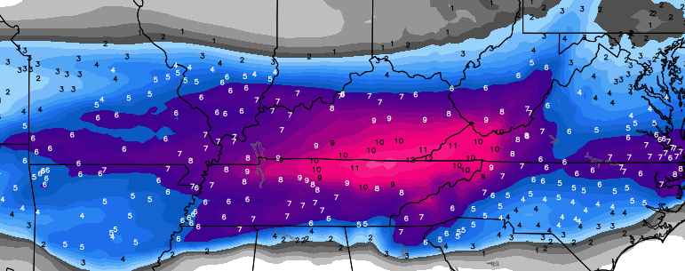
12z Euro EPS has 80-90% chance of over 6 inches for the southern counties..80-90% chance of over 3 inches for pretty much the whole state..
Show link please
I’m waiting impatiently for the models runs tonight.
http://i.imgur.com/eA27KyU.png
http://i.imgur.com/AhYyMex.png
that has a lot of people included with those maps
Thank u very much. Hoping this pans out. I’m bout 50miles west of the eastern tip of the state
Starting to really get pumped about this.
roads are really slick on 80 from prestonburgh to hindman in floyd and knott co got about 3 in best all winter
This is gonna be a powdery snow right?
I will gladly take a thumping
Winter storm threat here in Floyd co according to twc but also saying event total if 1-2 inches??! We got over an inch today and from the models I’ve seen all except the nam have us getting 6+”. But even nam has southern parts if the county getting close to 6″. Don’t understand why they are saying 1-2 total event. My area looks to be in the crosshairs for 6-10 from the models perspective
That is total event for today’s system 4+ for tomorrow nights system.
I get a kick out of those who take models so literally. Sometimes i laugh until I’m in tears..lol
Looks like ole Bill Meck is up to his tricks again.
Or that idiot, Bryant, that Chris finally booted.
oh you’re not going Bully me,doesn’t work that way. cyber bullies are hilarious.
And I’ve noticed from watching the feeds, that you springtimecharlies are the trouble making on here!.
and if you follow my link, you will see I’m no Charlie!!!
You are DEFINITELY not a Charlie 😀
opps i meant Bryant
3 inches of snow in Denver, Ky hear in Johnson County temp. Is 15 very strong winds. Hoping for 6 to 12 Sunday night Monday.
With this being a powdery dry snow with the amounts that are “potentially” projected 6+ inches, will power outages be likely?
@Kentuckyweather: Just saw the 21z SREF for this upcoming storm. It is loaded with moisture and much farther north. #kywx
Sounds like i better go to the grocery early tomorrow… and wine run tonight. Can’t buy wine on sunday..haha
@Kentuckyweather: For those asking about the SREF… the actual storm isn’t farther north. Just a ton more moisture that’s more expansive to the north. #kwyx
Can’t we all just enjoy the weather? It’s the only weather we have “Joe Bastardi”
more trends to the north? y yes ,that will be great please
Good thing about this tend is that CB noted it’s just showing more moisture and not the whole storm moving. I’m for everyone getting a good snow. This could be a good one.
I agree mr bob….this could bust a lot of trends
Yes I want everyone to get snow!
Looking more and more like a good ole fashioned thumping for a large number of us! Still brings out the kid in me, but as an adult, we also fear the loss of power!!! Bound to happen for some of us. ugh! Hope everyone has or has access to family or friends with backup heat.
Could be a good one. I’ve got kids that are fifteen and sixteen years old and probably not saw a snow over four or five inches. Would like for them to see a big one before they move out. Lol
Will Ashland KY get anything out of this? At least an inch? Weather gurus chime in!
Check in tomorrow. Should get a definitive answer by then.
Ahh come on now! I know some of you weather gurus wouldn’t mind making a prediction!
Probably not Ashland is too close to Huntington WV and we never get more than an inch.
6-12 inches Richmond south, more farther sout u go. top end Border counties
Even the nam has expanded north, we shall see
the BUBBA DOME will be thrashed, 12 plus in some areas.
Boom!!!!
I don’t to be without power for 2 weeks again.
Its the powder snow that came up we want, not the wet snow that cause the the power outages.
For whoever gets it: This
The weather channel is giving 6-8 inches of snow Monday for the Somerset area! Bring it!!
NAM is looking beautiful so far!
Chris said big time hit for entire state…anyone got a link
This is it at 39 hours. That’s as far as it is right now.
http://mag.ncep.noaa.gov/Image.php?fhr=039&image=data%2Fnam%2F00%2Fnam_namer_039_850_temp_mslp_precip.gif&model=nam&area=namer¶m=850_temp_mslp_precip&group=Model+Guidance&preselected_formatted_cycle_date=20150215+00+UTC&imageSize=M&ps=model
0Z NAM crushes KY
Link?
someone post the link to the NAM please
Heres a link: http://vignette4.wikia.nocookie.net/peanuts/images/a/a0/1107charlie_brown_lucy_football.jpg/revision/latest?cb=20100523172400
Just playing, hope we ALL get buried this time.
Remember CB’s bold prediction before winter? A double digit snow storm! Man just might hit that HOMERUN
coolwx.com has the NAM models
Why do I get a bad feeling about this? I am just really concerned this will be another eye candy big snow gone bad……
Wow what but but what .Im speechless..Bet some fols in Tenn. are sweating..
folks..lol
Show link!!! I can understand coolwx lol
Mother nature seems to ALWAYS find a way to make it NOT happen. Sometimes it’s the temperature so we get mostly rain. Others it’s taking it North. Others it’s air too dry, and we get this big storm on the radar and nothing hitting the ground…. Which will it be this time???
I don’t mean to be negative. I want this to happen as much as anyone else. But what I want to know is what could come in to play at this point that reduces or eliminates this event and then I will decide what I think.
http://twitter.com/kyfan502/status/566789397366861824/photo/1 new name is a snow hog.. taking it from Tn..lol
The northern trend continues
that was nam, not name..lol
From the looks of the run it looked to be as much if not more snow in Tennessee as Kentucky.
Yea Nam still has a good hit for Tenn..Looks like some of that may be sleet though close to the border of Ky..We sure don’t want the North trend to continue..The 21z SREF is unreal for folks out west..
New NAM shows the Dream Storm for SE Ky.!!
The NAM says BAM!
What will the ratios be? It has 3/4 to 1 inch qpf. As cold as it is, they would have to be at least 15:1
Latest runs look as if almost entire state of Ky to get hit. Anxious to see next model runs! Got my coffee fix! Gonna be a late one tonight folks!!