Good Tuesday, everyone. The snow dome came tumbling down on Monday as a major winter storm pounded the bluegrass state with record snows for some. Much of the state picked up double digit snow totals with parts of the east seeing up to 18″.
This marked the first widespread double digit snowstorm since February 1998. Something about that line sounds familiar.
#WKYTRulesWinter for a reason. @kentuckyweather Winter Forecast (Nov. 20, 2014). Many thanks to him and all of @WKYT pic.twitter.com/YxPTimc9YP
— Andrew Bailey (@_andrewbailey_) February 17, 2015
I should probably just quit forecasting at this point and walk away on a high note. Don’t worry, I’m still here and will blow a forecast soon enough to make you forget all about that. 🙂
Ok, let’s get down to business because we have some serious weather rolling in. Temps this morning may actually start out below zero for some areas. Afternoon highs will reach the upper teens and low 20s as clouds roll back in. Those clouds are ahead of another strong arctic system that is likely to produce snow late tonight through Wednesday…

That’s ugly and will likely put down another 1″-4″ of snow across the state. Winds will be gusty and could hit 30-35mph at times with blowing and drifting snow a good possibility. Temps will stay in the low and mid teens for most of the day. Wow!
Speaking of wow… the computer model temps for Thursday into Friday are frightening. Check out the low temps from the GFS…
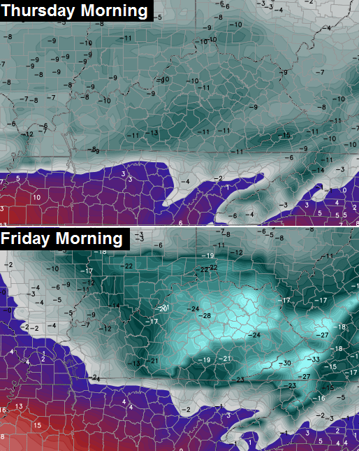
Not only would daily records be shattered, but monthly and all time records would be in jeopardy. For perspective… the coldest temperature ever recorded in Lexington is -21. The GFS has -28 as the Friday morning low.
The European Model also has temps getting into the -20 range during the exact same time.
You should take all necessary precautions to get ready for these brutally cold temps!
The weekend looks interesting as another storm system targets our region for winter weather. I’m just now beginning to really look at this setup and it has the look of snow and ice in our region. The European Model shows where the winter weather sets up through the weekend…
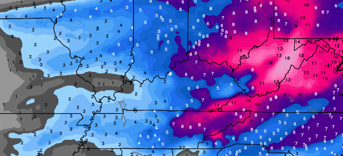
The Canadian is similar…
I don’t want to get too specific on this system until I can devote more time to studying it today.
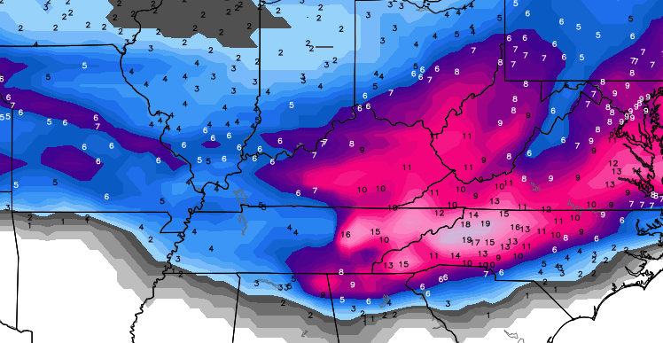
For the fun of it, look what the European Model says follows this system into next week…

Last week I said we were likely heading into a memorable period of winter weather. I was wrong… this period will likely be remembered as historic.
Regular updates return later today. Take care.

Looks like we’re getting what we wished for. Thanks Chris for keeping us updated. Everyone stay safe.
Mr. Bailey will hart co KY be in for 2-4 snow on Wednesday
Wow this is down right scarey. Snow is fun and exciting, but to see temperatures like this is really scary.
Thank you Chris for all your hard work. you come into all of our homes and keep us up to speed with the weather. You feel like much more than a weather man to us, you are a friend. Good job.
Well said! I agree with those sentiments exactly. Those brutal temps that are coming are just unbelievable everyone stay safe and check on the elderly and bring your pets indoors
Agreed, kman! Chris, thank you so much for what you do — sacrificing sleep, too. Most important, you help keep us safe and give us advance warning to prepare.
Ricvice is right — PLEASE do not leave animals outside in this, and check on your neighbors.
Amen!
Couldn’t have said it better myself! Thanks, Chris, for your dedication!!!
So I guess this new climate change means if you are cold, it is brutal and if you are hot, it is sweltering. There seems to be no in-between.
ManBearPig approved! Super cereal!
You know how you like a comedian, but you keep seeing them recycle the same material until it becomes cringe-worthy?
Great job CB, 12″ 3 miles west of Winchester.
According to the nws brodhead area of rockcastle received 14 inches, which Would be in line with my measurements.
Thanks Chris for all you do.
Looks like we are in for a rough ride.
First thank you Chris for the great work and dedication, it is much appreciated. We miss you in WV but you are still close enough to follow. I didn’t quite reach double digits at my house but still nice about 8 inches. Perhaps if we don’t melt too much today, after tonight’s snow we might get to double digits. I am near Hurricane WV.
The snowpack is really taking a toll on temperatures here this morning. Louisville Int’l reports 5 degrees with 7″ on the ground.
Valley Station just southwest of the airport, I have 7.5″ with a temperature of -2. Frankfort already at -7. We haven’t hit bottom yet this morning.
It will be interesting to see how cold we get this week.
I really thought the airport would have more than 7″.
We got in on a really nice band for about 3 hours that brought our total to 8″ in Worthington Hills.
I also seen several reports from J’town of 10″.
I will still never understand how a city makes their official snowfall total from a heat island at SDF.
Even though my air temperature is much colder than the airport this morning, this snow event marked one of the very few times that I had more snow than the airport. Sometimes I think my location is the ‘snow dome capital of Jefferson County’.
-7 in Covington this morning. I hope the cars will start later!
Yea, it is odd…
Just on cue, I’m watching WDRB, and Jude Redfield says this “the official temp is 5 in Louisville right now, but not alot of people live at the airport on that heat island. Most places are below zero.”
Seems like it would make more sense to have the official temp and weather measurements at the NWS office.
Because it helps push the global warming argument. If the world believes there is global warming then the government will give me more money to the scientists to study the event.
Never try to stop an agenda with common sense… Gets in the way of funding…
Not mentioning any names, but one local weatherman reported that the snow would go south and give us “very little snow”…..That turned out to be 9” here in the Huntington area! So glad to have someone who is ever vigilant in checking ALL the models to give us the most accurate forecast possible. I appreciate all you do to help us be prepared!
Not quite a dome buster here but still a decent snow/sleet event
What did you end up with Andy?
I haven’t measured this morning but it was around 5 inches total last I measured
Just measured close to 6 inches with 1ft drifts around parked vehicles.
Still have some very light snow falling I should add
Wish it could have been more, but I’m truly happy to hear you finally received a healthy amount. Looks like you’ll be seeing white for a while, too.
My dad measured close to 7 late last night in Knox. Without the three hours of sleet we would of hit double digits . I think we were the only area not directly on the border that had significant sleet.
Have you been to town yet?
Snowfall totals vary here in Laurel. We are about 2-3 miles south of London, we picked up around 9″. I know my fellow London blogger on here, Axl, said he got 11″ out in cold hill. Up near Livingston, 12″
What are some of you other Laurel county folks measuring?
10″ in the middle of town.
Just shy of 11″ in Sublimity.
Unless the temps get above freezing a few hours before the weekend event, rain is nothing but bad. Let us hope snow if not 🙂
1000% this
Agreed…even snow “haters” better be wishing for snow and/or sleet worst case.
NO icing on my cake, please.
Best perhaps also not to underestimate the impact of adding a few more inches with tonight’s expected event. None of this is going away and the super cold kicks in.
The positive though is the snow we had was a light powdery snow and not sticking on stuff. Ice on top of a heavy snow would probably make 2009 seem wimpy. I did not put 2003, since folks south of river only got rain, so not as many were hit.
Will be interesting to see what hits this weekend. Also curious if the snow pack is part of the considered factor as far as what falls this weekend. The outlook could be under appreciating this and off with temperatures as a result.
exactly on the temp part….I’ve already seen local MET’s adjust their highs from the upper 30’s in Louisville, to the low 30’s. I don’t see just plain rain being a factor.
Very hopeful it is only snow, or sleet or a bit of both.
Rain or sleet coating and then temps bottoming out followed by more snow…I remember that from the late 70’s. Then the snow melted and still cold so that water and sewer pipes were frozen at schools for weeks. 2003 the ice literally stopped in my acre sized yard…north face of house was a sheet of ice and the drive was wet and as we drove south…open. As Bubba, Mike and I know: in N Madison a mere mile or two present a vast change in weather product. The difference in exits 99, 97, 95….like microclimes often.
About 6 inches in Pine Knot yesterday with larger drifts in places. We had a lot of sleet yesterday too. It’s beautiful and still snowing this morning!
Minus 9 in frankfort this morning
We have all wished for snow and boy, did we get some! The wicked cold out there is bone chilling, but what could be here Thus.-Friday is scary cold. I’m thinking about the people who have to work in all of this and that would be road crews, construction workers, all emergency workers, plumbers, and of course, weather people. Many thanks and prayers for your efforts and safety.
Sorry, if I left some out….prayers and thanks for everyone who works out in this cold.
Accuweather predicted 3-4° F for this morning for Henderson; Nature chose -9° F. Clearly records will be shattered this week.
Crackuweather
Here’s the weather.com page for octavia snow totals and LOTS of KY pictures if you scroll to the bottom…….Some of them are wild looking!
http://www.weather.com/storms/winter/news/winter-storm-octavia-reports-snow-ice
Those are some really good photos, glad I looked at them.
Thanks for the link Mark.
Most of the models was showing round 2 for Ky for the weekend….Scary look..
You have a link?
Here’s one link Vinny..This is Oh Canada..Shows the QPF out to 240 hrs in inches….Look at Tenn..around 9 inches..Don’t know the precip type but that’s a lot of precip
http://tapatalk.imageshack.com/v2/15/02/15/005cd8493c2ace9fcbc96370bc234893.jpg
Ice seems to be a factor this time. And, another cold blast following this weekend’s event.
How do you even prepare for -20º??
Get in plenty of firewood, leave water running…. what else can I do to ensure that my house doesn’t crack wide open from sheer brittle-ness?
Kidding… kind of.
Thanks Chris. I appreciate your skill and humility.
Lexington doing a nice job on the roads. Subdivisions and cross piles are the sticking points.
Thank you so much for your tireless efforts in getting us through yesterday’s storm and preparing us for the upcoming potentially historic cold. Try to rest up for the next round coming up this weekend. God bless you buddy.
I just looked at the Jackson snow map and the Knox area had the lowest totals. There was more snow SW of us, more snow directly east of us. How we got significant sleet and areas just SW of us didn’t is odd. There was a report out of Lee co, Virginia yesterday which is SE of Knox and they did not get the sleet. Stayed pretty much all snown over there. Weather is an odd thing. If we stay snow like everyone around us, we get four more inches. Still a nice snow, but just pointing out how odd it was. Middlesboro probably low total in state.
You NAILED this one CB! I love that your Bold Statement panned out. No other meteorologists will go out on a limb like that but you are not afraid to take the risk and trust your knowledge. We appreciate that more than you know!
Now, as much as a winter weather lover as I am, I am officially done.
Not exactly looking forward to the next several days and what may be lurking for the weekend.
Anybody following CB’s tweets? Looks like tonight/tomorrow snow may turn into something more than a dusting. Not like yesterday, but with cold and wind, could make for an interesting day.
yes, new data coming in suggesting area wide 2-5″ of snow through tomorrow.
Mr. Bailey was NOT messing around when he said this time period through the end of February, 2015, will be historic!
This weekend looking a mess, as well.
Louisville is saying less than an inch tonight. I trust Chris…
they haven’t caught up, yet….I think you will see them adjusting later this afternoon or evening. Probably waiting on other models to come in before they up their totals.
Last I saw, every channel in Louisville was saying less than an inch for tonight, except for WHAS. They were saying we could see 1 – 2 inches. Has this changed, Lisa?
Christy Dutton just said maybe an inch on the 11 am news.
WDRB saying 1-2 effecting the morning rush
Two questions for any listeners…
1. How are the roads from jessamine into Fayette? Has anyone been out and about?
2. How confident are we in the 2-5″ tonight? I am thinking my kids may be out all week. Jessamine may be in school till July!
Thanks for all your hard work yesterday CB. I apopreciate your dedication to the blog and the people of KY. Your forecasts are the only ones we watch!
can’t answer the first part, as I live in Jefferson co…
However, I would bet on at least the low end of that (2″)…but, prepare for possibly more.
Thank you!
NWS in Jackson said that ratios could be up to 20:1 tonight. The new NAM has nearly all of Kentucky between 0.10 and 0.25 QPF for tonight so I’d say the 2-5″ call is very possible.
Thank you!
I haven’t been on 127, but I’ve been on New Circle, Tate’s Creek and Harrodsburg Rd. All were in decent shape. Neighborhood roads are definitely the most challenging.
New NAM consistent run of 1-3″, maybe more with higher snow ratios. Remember, though, not as much Gulf moisture with this one, just pure energy
that’s what is so impressive….this is an advisory level system coming in, and as you said, just pure energy from another arctic front.
I would be thinking advisories will be placed from the NWS by this evening.
So far, NWS is not saying ‘game on’, maybe up to an inch for a few.
we shall see….underestimating this system, wouldn’t be the first time the NWS has done so.
Impact alone (timing) should warrant advisory levels warnings. I’m sure CB will agree.
Well the last arctic front that came through the snow wasn’t impressive. I think isolated locations got white out conditions and a quick burst of snow, but most of us just saw scattered snow that wasn’t that impressive. Maybe the NWS are thinking this will be the same? I dunno…..I guess we will see. But we’re in a wild patterns where anything can happen.
there is more energy in the atmosphere, though, to work with this time around.
It really isn’t like any other system this winter. The NWS has been extremely conservative until the systems are almost on top of us.
Some places in Eastern Ky received almost 3 inches from the last one..
I better correct myself from a comment above. The 1-3″ amounts that may include higher totals takes into account everything that falls tonight and all day Wednesday into Wednesday night and thru Thursday morning rush. Therefore, a couple of waves could produce these amounts.
Yes, agreed to a point….
But, most of this will fall late tonight and early morning Wednesday in Louisville.
There will be leftover snow showers and squalls, which will be hit or miss. Most of the 1-3″ would be from the initial wave, it seems.
just showed my 5 year old daughter how to make snow cream and wow the look on her face when she took that first bite was priceless, she asked me how come it didn’t snow like this every year 🙁
Nws in Jackson just issued a winter weather advisory for tonight and tomorrow.
Thank you for your hard work Chris! I have been depending on your forecasts since March 2010 and you are my first port of call EVERY morning. Your forecasts have saved our bacon on more than one occasion, I can tell you – remember Chris’s Superstorm Sandy snow predictions anyone??? They laughed at me whenI ordered up snowshoes!! We ended up with 38″ of snow the day after they arrived!
Can someone with more knowledge than me please explain why this weekend’s system is looking more like an ice event rather than a snow event?
Thanks in advance.
Warm air from the gulf
Locked in cold air at the surface, overrunning warm air aloft = ICE
What parts of the state as of now are the models showing to be affected??
KY Mesonet site for Harrison Co this morning -14 degrees
NWS in Louisville updated their SPS from traveler’s advisory to info about 1-2″ tonight/tomorrow with locally higher amounts. Discussion stated that day shift would take a look at data today before decidimg whether or not to issue a winter weather advisory. Exciting weather week!
Hey, MikeS, I guess you can’t catch a break…The official total from the SDF (airport) heat island, was updated to 8.2″.
Not sure why it took until the day after to verify this.
Also, seeing NWS changing their tune possibly about the system moving in overnight.
Looks like from Chris’s last tweet….feedback issues fromt he NAM regarding the weekend….will need a few more model runs to to get a better handle on that threat. It could be interesting though and bears watching.
Can someone please post the new GFS with the feedback issues? Just curious to see what it says.
Thanks to the folks who answered my question above.
Might end up just to warm although the models might not take into account the snow pack we have on the ground already and how that can help keep temps down. There is a good discussion on this on the NWS site under forecast discussion if anyone is interested.
If I’m reading it correctly, much of the state just went under a Winter Weather Advisory for tonight.
It’s official…Winter Weather advisory in effect for the snow late tonight into Wenesday for most everyone!
Tough sledding out there today folks.
I’ve always heard this…..about models not taking snow pack into consideration……At this point, we have had a foot of snow, and a five inch snow before that; not to mention what we had in November. And now, another winter weather advisory for tonight, and then talk of snow pack keeping temps colder than forecast for the weekend with another storm??…….How much more excitement do you need in the winter weather world than this?
Ain’t it fun!!!
1 6 inch snow with a few coatings does not make for much excitement. Now driving a Mustang GT in a couple inches of snow now that’s excitement LoL 😉
No advisory that I can see for northeast kentucky yet. Are we out of this one???