Good afternoon, gang. This is a history making weather week across the commonwealth of Kentucky. Several days ago, I said this week may come up just short of producing the history making stuff from January, 1994. This week now looks to be on par with what happened back then.
Snow moves in tonight and Wednesday and will put down widespread accumulations…
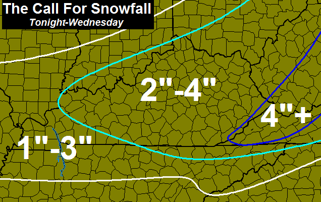
Locally higher amounts will be possible as a potent arctic system works through here. Winds will be very gusty with blowing and drifting snow a good bet. Temps tomorrow will stay in the teens.
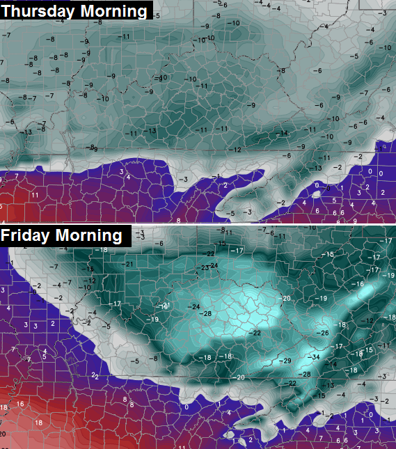
History making cold is likely for Thursday and Friday. I firmly believe we have a shot at monthly and all time record lows by Friday. The numbers from the GFS might even be too warm…
Historic!
To illustrate the point of how cold things can really get with a deep snowpack in place. Check out the lows from this morning…

The air in place last night was nowhere near as cold as the air coming in behind tomorrow’s system.
The weekend continues to look very messy with ice and snow possible.
The latest on all this on WKYT-TV starting at 4pm. I leave you with some tracking toys…


Take care.

Snow dome busted.
It’s all happening 🙂
That’s an aggressive snow map for tonight/Wednesday… I’ve not dug out from yesterday yet!!!
looking icy this weekend 🙁
2-4 inches on top of yesterday’s 15 inches, seems like last week we couldn’t buy a flake. When it rains it pours,
I still can’t believe that we’re looking at a possibility of -28 Friday morning!
WOW! Rodger felt Mr Bailey was thinking this was all possible reading “between the lines” of this blog in the last ten days. Congrats on your status, Mr Bailey, as the Weather Prediction King in Kentucky!
Rodger is flying to Vegas later today but will be back for much of the weekend mischief. Hoping it won’t be a cold rain.
weatherforkentucky.chatango.com/?flash
I am more concerned with the ice potential this weekend. How much moisture is the question…
Stop it Bubba….this is not an option.
Snow snow snow
ur obsessed with ice ….maybe u should seek someone out to talk to..:)
That’s funny. 😉
People talk about snow a lot more, so do they also need someone to talk to? 😉
Legit concern that COULD trump the snow for news. Not as glamorous but nasty stuff.
I think it is a matter of temprature this weekend rather then the amount of mostiure. Will guess CB will start to have a btter handle on the weekend tonight but will be tricky until we get much closer like Thursday evening.
I can’t even………
Please don’t say ICE. 🙁
As of 1:20 PM, it looks like Charleston and Wilmington are still asleep on the winter storm watch. Typical, though. NEKY and NKY usually get “surprised” whenever we watch Cincy or Huntington stations for our weather reports. Can’t all be winners, I guess.
Me too BubbaG ice is a very real concern on Tennessee border for me.
CBs post tonight could help clarify, but still several days out so maybe not. The snow we have outside was looking one state south for at the same time frame for perspective 😉
c-BIV, I saw your comment from earlier today about an adjusted total at the airport?
There was a total of 8.1″ reported at the NWS office near Theiler Lane out near Gene Snyder and Smyrna Road.
I still outdid the ‘official’ 7.0″ at the airport
no, they actually updated the “airport” snowfall was adjusted from 7.0″ to 8.2″…Jude Redfield added that in this morning to his broadcast. That was released to The Weather Channel and they changed it from 7.0″ to 8.2″ on their map.
Speaking of totals at airports. It’s still weird to me that KLEX reported 1.02 or 1.03 of liquid precip, yet 10.2 inches of snow – this all in 11 degree temps……so that would mean the ratio (at least for KLEX) was indeed 10 to 1.
well OLD SCHOOL 2 coming/ not ice!!!! remember little house on prarie when it was up to the top window, get ready
The current high on Saturday is supposed to be in the 40’s, are yall thinking because of the snowpack, the temps being much lower, and whatever precipitations falls, will be either snow or Ice?
What are we looking at here? Possible scenarios?
I guess my point is I would have thought that if the temps were too high, CB would be pointing that out already. The outlooks tend to get temps wrong with snow packs and therefore the type of precipitation sometimes as well.
CB did not bring this up, so perhaps he agrees with the temps and precip type… Wait for his evening post 🙂
I was thinking the temperatures are too high since the snow pack might not be considered for the weekend temps, but would have thought CB would mention this. Guess we will see.
Honey it is already like that here well close.
I have been watching the weather like a hawk this week. How did I miss this storm coming tonight? Whatever happened to surprise storms that dumped much more than expected. That’s what I like. I love hearing that a dusting is expected, then 6″ falls.
Maybe because weather is monitored to death in this day and age with technology, so nothing is as much of a surprise and it used to be…that’s my guess.
My brain –> “omg this is awesome. Looks so cool. Winter rules!”
My muscles and back from shoveling —> “please.make.it.stop.”
☝️☝️☝️This
not the temps though, nothing good about that
I just don’t see it doing a near 50 degree temp flip between Friday and Saturday night for the weekend system to be mostly rain. I’m betting it’s ice and wintry mix.
Don’t like the word MESSY for the weekend. Maybe the snow will keep temp down for plan snowc
What is the timing for tonights snow?
Love that episode of little house…so excited❄❄
Thanks Chris for all you! There is not a meteorologist I trust any more.
We are in the 2-4 inches area, but I’m thinking our Advisory hasn’t been issued yet, but may be as the front approaches. I guess it’s a rolling advisory? Somehow I don’t think the snow is going to stop at the Rowan- Carter line. Well, I guess it could, but like Chris said on Sunday, these advisories should go ahead and be issued to cover all areas to be affected.
NWS is concerned about possible white out conditions tomorrow due to winds and snow squalls.
The NWS in Louisville is saying the weekend system will start out as snow, then freezing rain, then to all rain Saturday with 1 to 2 inches possible. Can we really go from 12 for a high on Thursday, 20 for a high Friday to 40 for a high on Saturday?? It would take an extremely strong southern flow to get this much cold out of here.
I’ve ask CB about this very thing, but he’s too busy for lil o’ me (he says sarcasticly)
Short answer is yes. This cold is a from the displacement of the polar vortex. When the PV rotates out, there is usually good warming to its south and west as it does.
Still, it’s hard to believe Louisville can go from -15 to rain in just 36 hours. That’s nearly a 50 degree temperature difference.
my thoughts, exactly….it will have to be an EXTREME warm flow from the south.
How many times do these models not take into account the actual snowpack the warm air has to eat into. I’m starting to worry Bubba could be correct and this may be a bad ice situation.
Our best bet would be snow or sleet.
Ice and even just cold rain (1-2″) would be horrible. I mean, that would just lead to flooding.
Rodger has seen that much of temp swing before. If we’re south of a vigorous low pressure system, the cold air will say bye-bye very quickly. Big IF at this point. Models won’t handle KY’s deep snow very well and some mets think storm will take similar path to Monday’s biggie.
So says Rodger in Dodger!
Record cold to 1 to 2 inches of rain 2 days later……………..wow
With that much cold along with snow on the ground, how will we get 2″ of rain? We’ll see.
2-4″ tonight. 4″ would double what fell here yesterday Guess we’ere getting what we asked for! Thanks for the continued info Chris.
Considering it could be as cold at 20 below zero on Friday morning in Louisville, it’s amazing the weekend storm could be mostly rain for the city with a bit of frozen precipitation to start and end.
I’d like to think the large area of cold will force the storm to the south and east and keep much of the state on the cold side, but when the PV pulls out it usually results in a quick warm up on it’s south and west side.
I agree. There’s just alot of questions that need to be answered. Im surprised the NWS went out on a limb for this weekend storm way to many unanswered questions. Its a pretty much given this will start as a wintery event but how much what falls and when and if the changeover even occurs is completely unknown. If it gets as cold as predicted is it a sure thing we can scour the cold quick enough for the majority of what takes place this weekend to be a primarily a rain event?
I’m not buying it (1-2″ of rain for Louisvillle).
-19 is the all-time lowest temperature for February in Louisville.
Just wanted to pop in and tell everyome to keep an eye on this weekend. This system is 10 degrees from being 2009 all over again. If this rain turns to freezing rain at the same magnitude then we are talking almost 2 inches of ice. Lets pray this isnt the case. But hey im pretty sure 2009 wasnt expected to be that much ice til the day of.
I will bet anyone on hear that temps do reach 40 degrees in Lexington on Saturday. No way! Will guess you will see the temps begin to be lowered for the weekend tonight and tomorrow. Just a guess but I ma sticking to. Too much snow cover w more coming and super cold temps coming Thursday-Friday…..now ay 40 on Saturday! High in mid 30’s maybe!
FAYETTE Co. Schools have close for Wednesday, 2/18
I’ve seen it go from the teens to mid 40s and rain……so it can happen. I also read in the forecast discussion that, although there IS a snow pack, the air coming from the south is NOT coming from air over a snow pack….so those upper 30s to 40s could definitely happen….then again, who knows. It’s been so extreme this week that anything can change since it’s still only Tuesday (4 days out)
That makes sense and could be a problem if the rain falls a lot while the surface is still frozen.
Looking like a whole lot of spring starting after next week. 50-60’s, the last thing I want to see is winter end with a ice storm. This system looks like rain, which is good.
Yes, the warmer air comes in from up above and then tries to scour out the colder air below. Depends on how stubborn that cold air is, which can be most difficult to erode right near the surface of a snowpack.
Can someone tell me why I am seeing seagulls in Powell County with all this snow?!?! CRAZY!!
They are probably on the way to my house my Husband says I will feed anything.I can’t help it I love animals so much Birds Squirrels whatever.
Jefferson County Schools closed Wednesday.
When do the models come out that can give us a better idea for tonight/tomorrow? This winter weather has been great! Hope we can add some more tonight and maybe even more this weekend. I am fine if it continues as long as it wraps up by March 20th. First Day of Spring! Sounds like it may be a snow week instead of a snow day.
I am very interested in the Saturday/Sunday storm? Not sure anyone knows much about it yet. But I just saw on one website they are giving lows of 29 for Saturday night, yet heavy rain? With the snow still being around which, it should by Saturday as cold as it is going to be. If it does rain won’t it freeze on contact? Let the battle between Artic Cold and Southern Warmth take place.
Who wins???
Seems CB not noting besides “messy” suggests he might agree with the warmer air. If he thought it was something more, CB probably would have noted it in his post and also tweeted.
Folks might want to take a picture before Saturday, since might not be as picturesque then. Question though remains how much rain falls while the surface is frozen?
MEHHH
This weekend perhaps a big MEH
ss
It’s interesting that the state all time record lows are relatively recent. The 90s and possibly upcoming, since the 1800s. I mean, look how horrible winters were back in the day, yet the all time low temps have been modern. Just sayin’
You’re killing Al Gores agenda!!!
Watch out, there are agents on this blog. They push the narrative, yet respond with incredulity if refuted 🙂 Winning!
This is why we need a “like” button!
I’m just trying to get through the next few days. 🙂 Ugly, ugly setup this weekend. Signed Rob Van Winkle
I see what you did there
Thank you Vinny!!; I stated before I’m going say it again WHAT WARMING CLIMATE hog wash!!;;
Tell that to the people in Tennessee that used to get several 6″+ snowfalls on a yearly basis…yet hasn’t gotten a single 6+” snow in over 20 yrs. 😉
Chris just now reported 32• for a high this Saturday and 31 Sunday with crashing temperatures Sunday. Snow/Ice Saturday and all snow Sunday. it was on his 4pm WKYT news cast. I trust him more than anyone. Said it could down to as low as -28(actuall temperature) for Friday morning. Historical.
Ruh roh!
I agree. The NWS didn’t make a call until late Saturday for the Monday storm and they’re going to call this 5 day’s out? I don’t think so.
I would say I’m very surprised at the NWS doing this. But, really, when do any of their forecasts and advisory decisions make sense these days?
They did seem overly confident when they called for 1-2″ of rain over the weekend, with flooding potential. I’m still not buying in.
Ice and snow seems way more plausible.
http://gray.ftp.clickability.com/wkytwebftp/NEW7DAY-HD600_WEB.jpg
looks like the weekend is going to be a wash out calling for mid 40’s this far north
im up in Athens Oh
As of today last year, we had 18.9″ of snow. This year 18.4″. 🙂
Hey! Good stat MichaelT.
Snow is falling in West Knoxville. The temp is 19 with a wind chill of 10. Large flakes are being blown about by the wind. The trees are still ice covered so there is fear that the gusty winds may result in power outages. It is pretty but very dangerous. Stay safe.