Good evening, all. Our wild week of winter is about to get even wilder as we track more snow, historic cold and another possible weekend winter storm.
I have no changes on the snow for tonight and Wednesday… 2″-4″ for many as a potent system moves through here. Winds will be gusty with some blowing and drifting snows a good bet.
The cold coming in for Thursday and Friday continues to look totally out of control. Many areas will reach -10 to -20 by Thursday morning if skies clear. Thursday night looks even colder and could put some areas on a patch to monthly and all time record lows. The latest from the GFS…

Great googly moogly ! Wind chills would be way, way colder. All those numbers are deep into the danger category, so take any precautions to get ready. If we are to reach the absolute coldest numbers, we will need to keeps skies clear. If that happens… wow.
Snow will develop later Friday across western Kentucky and lift to the northeast as another storm system develops to our southwest. The models are going to struggle with the amount of cold and snow pack we have across our region. Once they figure that out, they will have a much better handle on how things pay out.
I continue to favor snow and ice and an overall nasty mix starting late Friday through Saturday with a change to plain snow late Sunday as temps crash.
The European Model shows the entire state dealing with wintry weather…
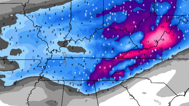
The Canadian Model does the same thing…
 Don’t look at those numbers as pure snowfall numbers. Those models are just showing you where they think both snow and ice will occur. Ugly!!
A full update comes your way later tonight. Take care.

Holy Cow. This upcoming weekend looks awful. Please more snow than ICE!!! Thanks for all your hard work this week CB. We really appreciate the job that you do.
I wonder what the NWS in Louisville was looking at when they called for 1 to 2 inches of rain this coming weekend. I just cant see us going from negative 10 to 15 Friday morning to around 40 Saturday. It has happened, but not with the entire state having 6 to 18 inches of snow on the ground and this isnt melting before Saturday.
The low would have to go well north of the state for this to happen, I think.
Thanks Chris
Chris, I am concerned about the weekend storm also. I noticed the NWS mentioning rain also, perhaps heavy. I too am having a hard time seeing the temperatures go from record cold to warm enough tor rain. I am concerned about the possibility of flooding were we to have heavy rain. Thankfully, I see you are not mentioning rain at this time. What is your thought on the possibility of rain? By the way, great job as usual predicting our giant snowfall!
One silver lining to the cold is at least we have enough snow on the ground that water lines should be okay. I dug under the snow today and the ground is not frozen. Snow is as good insulator.
So the snow pack is probably not factored after all. Makes more sense and more likely we get smacked with stuff (ice) other than snow for part of the weekend. We probably do not want a lot of moisture from this since warm air aloft could be a main player.
NWS is wrong on this weekends storm.
All-time record lows could be in serious jeopardy if that pans out! Then 36 hours later we reach the 40’s possibly. I know, we have a deep snowpack across the entire state of Kentucky, but just like CB says “Never underestimate the northwest flow,” we should also never underestimate the southerly flow, since we do live in KY. WAA is powerful, and can raise temps into the 50’s if it wants to with a 3 foot snowpack. It’s not like the snowpack is way down south in New Orleans, or else, I would believe we wouldn’t get that high in temps. I mean, why doesn’t it reach 70 degrees in Ontario, Canada in the winter? Because of all the thousands of miles of cold air and snow the warm air would have to go though. Regardless, I really hope we stay below 32 degrees this weekend, (without ice) but that would be a far stretch, especially for Southern KY.
So essentially what you’re saying is a snow pack doesn’t matter if there is no snow pack south of you?
Yeah, and warm air can easily make it through if strong enough, which it will most likely be this weekend.
wrong
Lol, well it does matter, just nowhere near as much if you have strong WAA.
No matter what happens let’s say Saturday cause appears Friday will be wintry. Not looking good and even a cold rain will be too close for comfort for another potential ice storm.
http://forecast.weather.gov/product.php?site=PAH&issuedby=PAH&product=AFD&format=CI&version=1&glossary=1
that warm air will fool some people blowtorch temps on sat and sunday
Oh look Bryant is back!! Sooooo….. What’s your definition of blowtorch temperatures for the weekend? Please humor me Im in need of a good laugh.
mid 40’s rain with melting snow
Wow not much of a torch lol
I don’t get the vibe that that’s Bryant. If I remember correctly, he used proper grammar and formed complete sentences.
Maybe that’s part of his disguise lol
I’M WITH CHRIS ON TOTALS HE IS GOOD FROM FAR OUT. OH YEA GO VOLS TONIGHT!!!!!!
With two bogus goal tending calls and three ghost fouls, I think the officials might be with you 😉
i hope it does not get that warm i want all snow
I’m with ya Adam. GO VOLS!!!
On a weather note. Those temps look insane!
Hey Chris, it’s time to start banding these fools..! J/K
Go Cats, BBN…! 26-0
Expected a closer game but Vols missed a bunch of 3s and free throws. Surprised of this at home.
Unfortunately we blew it. Oh well, I’m ready for football anyway!
Negative 20 to 40 above and rain within 36 hours. I know it’s possible, but any thoughts as to if that really may happen. Water sitting on snow….flooding….then all that water freezes with snow on top. Sounds terrible.
This all from the thoughts of NWS
Temp was for cast to be 13 for low tonight in Pine Knot . It’s already 10 ! I dread the cold …
I am in awe of the beautiful nature photos that people tweet. Gorgeous sunsets with snow covered fields and such.
If this weekend is all snow we would get dumped on. It appears it may be everything. It will be interesting to see how it plays out.
We want snow or nothing for obvious reasons. Hopefully CB sees a lot more snow than rain. That, or the blow torch overwhelms and we get mid 40s rain 😉
I’m not picky…I’ll take mid-30s and rain. As long as it’s the “R” word and not the “I” word…
If it is going to be winter, it might as well snow. If it is going to be cold, it might as well be record cold. Otherwise, it is just a dreary season with nothing happening. Of course, may all keep safe throughout. Hopefully this weekend is snow, not rain or ice.
26-0.
The 400 Thousand a Year President Benson at EKU has decided to open Richmond Campus tomorrow at Noon with normal schedule resuming after being closed since Monday. Apparently he thinks this is wise with 2-4 more inches coming tonight and the brutal cold temps coming. Its just absolutely ridiculous. Doesnt he watch Chris Bailey and follow the state’s best weather blog??
Is there any end in sight to the snow and cold?
Please. Make it stop. Spent all day shoveling the Braskey driveway, which is FOUR FOOTBALL FIELDS LONG, and the pet cobra was no help. Guess Bill Brasky will TIP ANOTHER, OR FIVE
Only five? But, you are BILL BRASKY
I’ve seen a mention elsewhere of thundersnow being possible, is this something Chris thinks may be a possibility too?
On second thought, i’ moving back to NOLA. I would rather deal with the hurricanes than this crap. And Rolo, f u.
That’s not appropriate, since kids read this blog too
…….. food utensils? I think Rolo has some of those already.
So how about them Vols! 😛
This is going to be both the snowiest and coldest week of my life. Wow.
Here we go again some people like to twist and turn in what the weather gonna be this weekend. Let CB do the Job and quit second guessing what mother nature gonna do.Life will go on regardless what happens
The 0Z NAM tells the GFS to get with the program for the weekend.
going to be ugly this weekend.
1-2″ of rain? uh….not happening.
but, sleet, snow and even freezing rain are all happening.
Explain please
As CB mentioned, the models should start to pick the snow pack up. Should be a cold verses warm battle. Hoping snow or the less harmless version of rain wins.
bm –
That’s what the comment section is for, to discuss the weather, etc. I mostly come on to ask questions. I’ve learned several things over the years…..For instance, I never knew a snowpack could cause a sunny day to be a cloudy day. I didn’t know that snow could evaporate even if it’s frozen solid (called sublimation) And quite honestly, until a few years ago, I had no idea snow cover could cause temps to be colder than if it were bare ground…..
I love learning more about weather, it is such a great field of study that I would love to get into, and I will soon!
Chris’ latest tweet!
Cool Snow Lexington Time-Lapse I found from the Monday storm.
http://www.youtube.com/watch?v=K6de83keibw
Anyone wishing for more snow and ice is ignorant!!! I have over 15 inches in my yard and it’s horrible.. my neighbor Alice, fell and broke a hip today in this horrible mess. Seeing people suffer isn’t fun or cute when it comes to weather.
Sorry to hear that 🙁 I hope she’s ok
Again, more people are hurt in good weather, so perspective is needed the other direction as well 😉
Snow is better than ice, so that is the point.
Then this blog isn’t for you. According to the deffinition you’ve laid out, most of us on here are ignorant.
No one wishes harm or injury to another human, but extreme weather is fascinating and that’s why blogs like this are so popular.
Snow storms, blizzards, tornados, hurricanes, floods, etc…. Are fasenating, and people have unfortunate accidents (mostly due to blind stupidty) and not preparing, but it doesn’t make them any less fasenating.
I love extreme weather and I’m not about to apologize or take the blame for others misfortune.
Ok, I’m done
This blog isn’t just about snow , vinny !!!!
It pretty much is in the winter and don’t worry Barb, you’ll have your turn in the spring , summer and fall when it’s not snowing.
Some Louisville Mets are saying this weekend system is making them a little uneasy.
Yep.
What does the 0z NAM look like prelude?
Hopefully not for Wagner’s Ride of the Valkries 😉
This winter reminds me of 93, cold and snow early then very warm January and some of February, then several winter storms in late feb and the epic superstorm in march!
Snow has started falling in New Albany, Indiana!!! New Albany is right across the Ohio River from Louisville.