Good Wednesday, everyone. Another round of snow is rolling across the state today and is adding to our already crazy snow depth. This will be followed up by the potential for blockbuster cold temps for Thursday and Friday. Those numbers may rewrite the cold weather history books.
The snow out there this morning will zip through pretty quickly and could be heavy at times. Some blowing snow is likely as this initial system works through here. Snow showers and squalls will then kick in this afternoon and evening. Many areas should be able to puck up, at least, a couple of inches out of this. 2″-4″ looks like a good bet between this morning’s stuff and the squalls later today.
Winds will be very gusty and could top out at 35mph at times. That could create some blowing and drifting snow. I have also seen similar setups produce some thunder and lightning.
The cold that comes in behind this is absurd. Readings by Friday morning will drop to -5 to -15 and that would shatter records. Highs during the afternoon will stay in the single digits. Wind chill numbers will be MUCH colder than what the actual temps are and that’s bad news. I can’t rule out some snow showers and flurries during the afternoon.
Thursday night and Friday morning may see temperatures head into the history books…

Do whatever you need to do to prepare for that kind of crazy cold!
Friday afternoon will see moisture returning from the southwest. The initial surge is likely to be in the form of snow and that may introduce a very messy weekend of weather around here. It will be another day or two before the models catch on to the snowpack and the depth of the arctic cold.
The NAM seems to be figuring things out before some of the others. Look at the ugly stuff from Friday afternoon through Saturday morning…
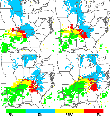
Snow, sleet and freezing rain show up across much of the state during this time. That’s a situation to monitor closely in the coming days.
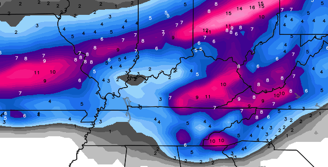
The Canadian Model keeps showing a lot of frozen precipitation here this weekend…
I leave you with the tools to track the snowy weather we have out there today…


Hamburg Area from WKYT Studio
Lexington

I-75 @ Winchester Road Lexington
US 60 @ US 127 Frankfort

US 127 @ Frankfort Frankfort

US 60 @ US 460
Frankfort

I-75 MP 127
Georgetown
I-64 MP 97
Winchester
Mountain Parkway near Slade

US 23 at 119

I-71/I-75 at I-275
Near Covington

I-275 at Mineola Pike
Near Covington

I-275 approaching KY 20/Airport
Near Covington

Bluegrass Parkway Bardstown

I-65 MP 32

Downtown Louisville @ 2nd & Broadway
Louisville

I-64 @ I-264
Louisville

I-264 @ Freedom Way
Near Louisville International Airport

I-75 at MP 36
London

I-75 at MP 23
Corbin

US 41A Gate 5 Fort Campbell Entrance
Fort Campbell

I-24 MP 4 @ US 60
Paducah

I-24 MP 7 @ US 62
Paducah

I-65 MP 36
Near Bowling Green

I-65 @ 234
Near Bowling Green

I will have updates later today. Take care.

Thanks Chris. Here’s hoping Lex avoids ice this weekend. Bring on more snow! Get some rest, Mr. Bailey
Hopefully no heavy rain this weekend and just a small amount of ICE, more snow will be the best senerio at this time!
Wow! Looks like a whole week out for the kiddo’s!
Heavy snow in frankfort the last hour, huge flakes rockin baby!
Sorry if that sounded like duke Vital
Woke to an inch of new snow here in Berea. Still coming down.
Not sure what’s going on. I’m certain I set my Amazon “Subscribe and Save” auto-delivery to once per month for snow.
Was 2 degrees here in my area of Knott County at 2:00 A.M.
It’s up to 10 now……
Started out at 1F and it warmed to 10F
Kids say they got 11″ on the hill in bimble…
a drift I could see but not outside of drifts most areas in Barbourville seen 6 inches or so I had 1ft drifts yesterday
Overachiever here in Hartland on SE side of Lex; at least two inches of fresh snow and still snowing. It has replaced anything that melted in the sunshine yesterday and more and of course covered the driveway and sidewalks again. More shoveling! But I love it!!
Husband just said we have about 2.5 maybe 3 New snow here in Burgin.
slushy streets under the snow with dropping temps all day, I’m worried about it getting so cold that the slush freezes to a thick layer of ice and really get chaotic out there. The effective temps for the chlorides used on the streets is only to 10 degrees.
pouring snow in London – very low visibility, extremely bad roads
I just hope and pray with the temperatures forecasted that the power doesn’t go out.
Still a lot of ppl without power here in east tn..due to icestorm
I hate to hear that. Hopefully they can get people back on before tonight through Friday. It’s going to be brutal!
Actually getting something other than freezing rain here!!pouring the Snow about half inch on top of freezing rain accumulation of .50″..
Athen,tn.
Snow
18°
Canadian model has snow/sleet/zr for the weekend.Apps says yuck.Although looks more like snow than anything.just one model though,
Stuck in my subdivision and driveway this morning so no work for me today.
2″ of new snow on top of our 8.5″ from Monday.
10.5″ now and currently NE Louisville is under a heavy snow squall. Visibility about a quarter mile.
K, so looking outside my subdivision, driveway covered, people’s footprint’s covered. Maybe 2 inches and it’s still snowing……
The snow has started in Pikeville. Thanks Chris for all you do. Group Hug for warmth.
Thanks Chris. We have about two inches of new snow this morning and it is still coming down at the moment. In fact it is pouring! Don’t know how much longer it will snow but it sure is doing it right now.
I am concerned about the weekend, with the chance of freezing rain.
ON toop of all the snow, that could be brutal. But I know you will keep us up to date. Thanks for all you do, Chris. Everyone have a safe, happy, and WARM hump day!
Id rather have rain this weekend than snow.I’m sick of seeingthis stuff.I really am.I have a back ache now because of shoveling the snow that snowlovers out there love and I don’t like.I’m not blaming anyone,I’m just tired of snow.
The weekend could likely be bad for some folks, any way it pans out:
1. Heavy snow sticking on trees an lines and adding to current totals.
2. Rain falling with frozen surface: Same as above
3. Blow torch kicks in and we have upper 30s to low 40s there could be flooding.
Combination of all the above perhaps.
Maybe the system will not have as much energy and be light to moderate 🙂
The warmer air would be further south. CB still thinks the models are off on temps and will eventually show colder. Snow pack attack!
I agree…ground temps could struggle to get above freezing, but with the low cutting west of us the temps above us will start to go above freezing giving us a potential period of freezing rain before the warm air wins out. Just hope we don’t get the heavy rain
3″ of new snow this morning near downtown Lexington off of Southland Drive. I now have a 13.5″ snowpack in my yard. Going to be interesting to see if we can add to it this afternoon and the rest of the week and upcoming weekend. Will the deep snowpack and Artic air keep the weekend storm all snow in and near Lexington? We will just have to wait and see. The models seem to be figuring out all of this and making the appropriate adjustments with each run. It will be interesting to see what it does with all of this. I’m leaning to an all snow event in Lexington. If that’s the case,then we could add another 6″-10″ to our current snowpack. And then another shot of Artic air Sunday? That’s just unreal. After all of this, I will officially have had my fair share of winter and be looking forward to spring. I really enjoy reading everyone opinions on this board. Thanks to,Roger in Dodger,Bubba,Andy Rose,Upslope,Tony,Rolo(Coaster),Coffeelady,Mark in Lexington,C-Biv,Jeff Hamlin,Appsrunner,Blizzard Tim,Todd,Allen and anyone else I forgot. I may not always agree with everyone,but it is very educational and entertaining at the same time. I have learned something about weather from everyone of you guys. Please keep it coming and thank you to to best Weather-Dude in all of Kentucky,Mr Chris Bailey….you are the man CB..
I hear my wind chimes so I looked outside my window and it was a total whiteout. Wild looking……..
I found this posted on YouTube yesterday. It was posted yesterday it looks like but I do not think this is from the current snowstorm……but it’s still very cool!
http://www.youtube.com/watch?v=6YYRK9OsZrE
Current data from Clays Ferry Bridge on I 75 N-S…..frequent accident area between exits 104 and 95:
AIR 20.6 PAVEMENT 23.8 SUB-PAVEMENT 29.4
all that means it is treacherous and icy…Be Careful out there!
3″ of new Snow on top of 11″ of old snow in South East Clark Co this morning. This snow seems a little wetter and much slicker than the large snowfall we just had. Roads are a mess but road crews are doing what they can. Will soon be to cold for Salt to work, these roads may stay this way a day or two.
I’ve got around 3 inches of new snow in J’town as well, an inch of which came in the last half hour with an extremely heavy squall, NWS even put out a special statement for the squall. Would be crazy if we were to end up with like 5 inches after the squalls this afternoon.
Yes, Jude Redfield on WDRB said people in NE Louisville could see up to 5″ of snow today because the squalls are going over and over the same areas.
We picked up 2″ from the original snow ahead of front this morning and now have 2″ more of fresh snow. 4″ now.
MikeS, you really must have a snow forcefield around your home!
Officially over a foot of snow on the ground now, at my house.
I dont get it I know parts of Valley Station has around 10 inches and they just got a very decent snow squall I literally just drove through.
It’s odd, for sure.
We have over 12″ of snow on the ground now in NE Louisville.
I got the shoveling out of the way. It’s just going to be almost impossible to shovel by evening.
This is wild stuff. Everyone keeps mentioning Ice but Chris never has mentioned he thought it would be ice has he? He was thinking all snow right?
There is a lot of black ice under this new snow in Lexington. The hills on Upper and Mill are closed, and Nicholasville Rd. and Rose Street near UK have cars stuck everywhere.
PLEASE MAKE IT STOP!!!!!!!!!
Over 2″ of new snow to push us over 10″ for the week and it’s still coming down.
How many inches does hart co ky have any body please
Thank you Chris. Roads are pretty bad in Lexington. Fresh coat with ice underneath. Please take it easy out there.
I had a bare road in my subdivision in east Louisville last night. It’s gone again. Measured a little over 3 inches new snow. About 9 total now. My son is out of Mt Dew and cheez-its. I’m thinking a trip to Kroger before the wind starts would be a good idea.
Brian Goode tweeted that the WPC had put a good chunk of the area in a slight risk of 4+ inches of snow for Friday PM before warming changes into freezing rain.
Those are not happy words.
Snow to freezing rain . . .
I do love all this snow.
About 2″ of fresh snow on top of my 10″ here in London. If we can get a couple of squalls to form up, could easily hit 4-5″
Drove to Lex from Berea at 7 AM and then back again. Roads are utter crap going NB on 75. Usually only the middle lane clear. Didn’t see any trucks on the way up but a couple of 75 SB coming back.
75 SB is either in decent shape or bad depending on where you are.
It seems many drivers in Lex think that the only way to drive in the snow are
1) stomp gas and spin
2) stomp brake and slide
3) change direction quickly to go off of road.
GEARS people, everyone has them for a reason.
Lots of crazy (weather and people) out there. Be careful.
SNOWING again in Clay County. We have about 15 inches total snow now. Still snowing here.
NWS jackson mentioning winter storm potential for friday night and into saturday, before turning into rain. Several inches of fr rain, snow, sleet on top of the 12″ plus, add some heavy rain, and talk about epic mess.
couple more inches in the Annville area in Jackson Co, total little over 15 inches..
Wow! It is snowing extremely hard right now, white out conditions. A quick 2 inches already this morning.
We’ve been sitting in a nice snow squall for a while. Snow is coming down very heavy.
Crossing fingers the energy is weaker for the weekend. Could be rough if not.
Picked up about 3 inches in the Lyndon area of Louisville. Around 9 AM or so, it was all but a white out. Officially, SDF has now recorded 9.9 inches this week. I haven’t seen that much, though.
I’m still focused on the weekend. The consensus seems to be a question of when and not if the precipitation turns to rain. I’m still hopeful of a more southern track that spares many of us ice.
Sun shinning in Spencer County near Taylorsville. Snow covering all the hard work my husband did over the last couple of days. Looks like I will be making up school days in June….again. However, I am enjoying the time off. Stay warm!
This mornings snow is beautiful. Picked up about 2-2.5″ bringing us to around 6″ total this week.
Snow is tapering to a few flakes, and the temperature has RISEN to 26 degrees. Some winds have picked up and the sky looks ready to clear. We have maybe 1-2 inches here in NEKY, not much fell this a.m. For this weekend, I hope we get snow & not freezing rain or ice. With all this snow we don’t need more, it’s just that the ice is wicked evil. Yep, the sun just broke through.
Just wondering… You know how we fill the blog with “You mean you got ___ inches! we only got ____ (always way less)! Must be the ‘dome’. ” Well, is there any place in KY that did NOT get at least 6 inches? (6 is my bar for a “good” snow fall. What do you think? I heard the extreme southeast – M’boro may be the light end and central KY the heavy end. What do you think?
Mets are starting to pick up on what CB has been talking about for the weekend. It appears to be tracking more north which means bigger chance for impact and snow pack becoming a factor. Would not be surprised to see an update from CB today that discusses the potential.
Bubba-
What are your thoughts on the weekend?
All depends on the flow and how the cold air hangs on. Seems could be half snow and half mix. What type of mix depends on how south your location and off course the actual flow of the system.
Still hoping the energy is less to reduce impact. Mix of snow could be higher. CB post should be interesting.
I live in Middlesboro and we do seem to be on the light end. Not sure how much we have but way less than most of the totals I’ve seen on here.
Can’t wait to see how the weekend plays out! The battle over the temperature! My bet is temps will not be as high as projected. I am doubting 40 degrees!
WSWARNING now out for eastern ky!!! 3-8 inches
Where?
bright sunshine in London right now, should help melt roads back off again.
That Met. Henry on AccuWeather has been saying for two days rain and flooding KY and WV this weekend. I hope he is wrong, since he usually only focuses on the northeast. Chris is way better. By the we have pouring snow and sun at the same time near Hunt. WV.
Still sunny and a “warm” 26 degrees here. Roads are melting some, very few flurries. The high was supposed to be 19….sun is getting things warmer. Hope we do not get rain this weekend. Please.