We have wrapped up a very soggy day across the Commonwealth of Kentucky. This messy run isn’t finished with us just yet. More rain will be coming in the days a head. But something falling from the sky isn’t new for us at all… right?
Most areas will catch a break from rainfall on Wednesday. I said most areas, not all areas. The same system the passed through Kentucky on Tuesday will not be far enough away to keep rain chances down completely. There will be just enough energy off in Tennessee to keep rain chances alove and well for Southeastern Kentucky. Keep in mind that this is the same place that received more widespread high water issues from our last winter storm. While many were seeing snow pile up… they were seeing rainfall accumulations add up to some pretty impressive amounts. These showers will be light in nature, but just enough to keep the already overly saturated ground well… overly saturated.
Here’s what the NAM is showing with that system. Showers linger into eastern Kentucky. into the early morning hours.
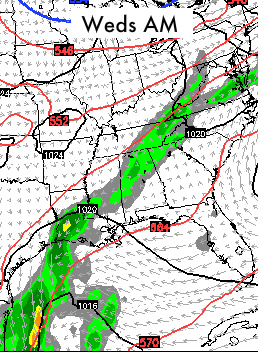
Again… this amount of rain isn’t a big deal when looking straight at the data. It’s all about keeping the rain around! That’s exactly what we have in these projections.
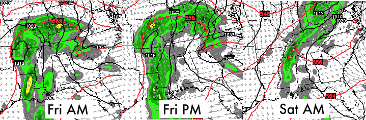
The moisture supply from the gulf of Mexico is running wide open. The conveyor belt of moisture will continue to push into the Kentucky well past the end of this first round of showers. Keeping everything drenched and ready for the next round. This round has a very similar and saturated origin. Most areas picked up around 1″-2″ of rainfall from the Tuesday system. Our Thursday night/Friday system will bring amounts that will rival that or perhaps even surpass in some cases.
It’s the late week system that has me a little more concerned. With no solid drying out period expected, the next wall of water won’t have a tough battle to cause more high water issues this week.
The GFS is picking up on the idea and actually keeps some of that heavy rain in the area for early Saturday morning too.
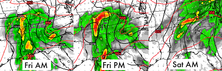
The NAM barely gets this in its sites due to it only being an 84 hour window of time. While the differences between the NAM and GFS are not completely obvious there are a few clear differences that you can note. As I have said for a while, I know this new version of the GFS is supposed to be better but there are certain precipitation set-ups that it still over does. Just like in this case. The NAM is picking up on a break in Southern KY while it appears to rain non-stop on the GFS. I think the end solution will look more like the NAM (BELOW) and there will be a small window of no rain for some. It won’t last long though as some heavier amounts will try to wok back into the region.
These numbers look right on track with my thinking as we move forward into the middle and end of the week. This is a lot of water for anytime of year, but given the current circumstances it’s even more. The soil acts like a sponge and it can absorb an enormous amount of water. But even a sponge knows when to say enough is enough. The saturated ground is about to cry uncle with all of the recent snow and rain.
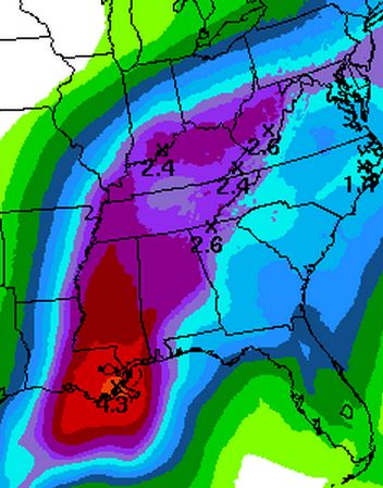
Within that swath you can expect somewhere between 1″-3″ of new rainfall. I wouldn’t be surprised if some areas picked up a little more under some of the heavier bands of rain.
As for temperatures… it’s al mild until Sunday when a quick shot of cooler air arrives. I promise it won’t be the last! Still looks like some much cooler air gets to Kentucky and stops! It doesn’t make it much farther south. We’ll take a closer look at that in my next post.
Take Care

You know it’s bad when I’m following winter weather in Hawaii than here. Blizzard warnings for the Big Island summits.
Hmm… this post is so odd to me. Probably because of the variations in the forecasts and uncertain-ty that is being explained in great detail on this post. I feel like I’m reading the style CB writes for snows, but for rain. Regardless, great job CB! Keep up the good work!
So according to the Courier Journal, the Louisville MSD folks don’t seem concerned about flooding potential. Should they be?!
I only wanna hear about rain if Luke Bryan is singing about it.
Sick. Of. It!
At least he said much “Cooler” and not much “Colder”….I’m looking for anything positive after this past month.
I notice you are not saying Cold air, so maybe we dodge the white stuff 🙂
And especially the salt.
don’t want rain anymore than I want snow. Would rather have is 30 degrees and dry than 60 degrees a wet.