Good Thursday everyone and welcome to more of the same. As a matter of fact the next 48 hours can produce a major severe weather outbreak for much of the country and that would include Kentucky.
Since this promises to be another active day on the blog… I will hit the high notes to get things started out. We have to be watching the northwestern sky today for rounds of thunderstorms that will come rolling our way. Damaging winds and large hail will be the main severe threats. As always the isolated tornado cannot be ruled out. The boundary that was the focal point of the storms Wednesday was situated across southern Kentucky. As this returns slowly north today… the storms to our northwest will use this as the train track if you will.
Here is the latest from the storm prediction center for today…
Radar…
DO NOT underestimate the flash flood potential!! The ground is waterlogged across much of the state and just can’t take another drop. Please watch the streams as well as the sky!
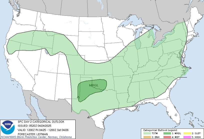
Later Friday into Friday night is likely to feature some wicked weather across the region. The Storm Prediction Center has already outlooked much of the area in a slight to moderate risk for severe storms. If you know how the SPC works… a moderate risk on a day 2 map is big time! Here is their outlook…
The blog will be on top of things today as usual so please check back for updates. The Twitter feed has been having some issues in recent days but I will continue to update it and go live on this blog. You can sign up for free cell phone text messages from me.
Have a great day and take care.
Select Page
Hey Chris
We’ve been lucky with most of the flooding/storms in Lexington. Nothing much here YET. Anyway, do u think the pattern will dry out next week or is it going to be more of the same? I was reading where the ridge would try to build in from the west but at the same time the trough would be on the east coast and cool weather would be there and Kentucky would be in between the extreme hot and cold weather which could cause storms; I don’t see anything for next weeks forecast indicating rain at all though. Hopefully nothing for south/east KY. They have had way too much!
DERECHO IN PROGRESS MAKING A B-LINE FOR KENTUCKY!! WEEE!!!
Just wanted to let everyone know that my husband passed away last week. We were in the hospital 21 days, but in the end the infection won out. I probably won’t be on again until this fall as I am not staying at home much right now. Please keep me in your prayers.
Getting real concerned about this radar here in Scott County. At least give the weathermen a chance to sleep in today. It looks like a severe storm watch has just been posted for someone closeby.
here we go again http://www.spc.noaa.gov/products/md/md1199.html
and WXMan you can take your Derecho and stick it in ya Garage 😉 SE KY had enough yesterday
this derecho means business with heating of the day underway and a lot of mositure i doubt it will weeken much. severe thunderstorm watch up for the west.
so, with this next round of storms, what about east. ky, especially pike co?
the Weather Channel shows that these storms will be taking a SE flow. Anyone else agree with that?
Yes it does mean business! WoW! 2″ of rain falling with this one Derecho! 14″ trees snapped off! Holy smoke!
I think the blob is moving SE, but the actual line inside the blob is moving more due south. Looks like a heavy rain event at least for Central KY.
Really cool pics on the NWS Jackson website. One of a wall cloud and one of a funnel cloud from yesterday..
Out of Indiana..
18″ diameter trees snapped, railroad cars turned over, windows blown out of houses, etc. WOW. But…it’s all going to miss the Bluegrass counties.
Well since people live in other areas besides the bluegrass we need to be concerned about those folks to especially those that have been hit twice already this week
http://www.spc.noaa.gov/products/md/md1201.html
Will it miss Bluegrass or just be weaker?