Good Sunday, everyone. We have a very steamy day taking shape across the bluegrass state. The very warm and humid air mass will pave the way for an increase in showers and storms tonight and Monday. Severe thunderstorms will be possible during this time.
Highs today will reach the mid and upper 80s for much of the region with a 90 possible here or there. Humidity levels will be much higher than what we’ve had recently.
A strong cold front arrives Monday with a couple waves of thunderstorms. The first arrives overnight into Monday morning and should be weakening as they move in, but severe weather is possible across the north.
Skies will try to clear a bit ahead of the actual cold front and that should help increase the instability already in place. Showers and storms will then blow up and could congeal into a healthy line of severe storms sweeping quickly across the state. Damaging winds and large hail will be the primary players to watch for.
Here’s the Monday threat area from the Storm Prediction Center…

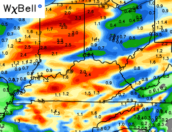
The NAM continues to be rather aggressive with the storms and heavy rainfall…
I have you all set to see track what’s going on out there today…

Today’s risk area

Current watches

Possible watch areas 


I will have updates as needed. Enjoy the day and take care.

Extremely dense fog on the drive from Richmond to Danville this morning. Looking forward to the storms later but hopefully nothing too crazy. 😉
No surprise with the fog, dewpoints and actually temperature are running about the same.
This is why you should always keep some John Carpenter music in your car or on your phone.
I’ll listen to some now. 🙂