Good Sunday afternoon, folks. A strong cold front is slowly approaching the bluegrass state from the northwest and will touch off some big boomers when it arrives. I’m seeing a pretty good signature for strong and severe storms as we roll our way into Monday.
The first line of storms drops in late tonight and early Monday. That line weakens as it crosses into Kentucky. Another line of storms will quickly develop during the afternoon and sweep across the state through the evening. That line may bring an increased threat for damaging winds.
The future radar from the NAM shows a heck of a line of storms…
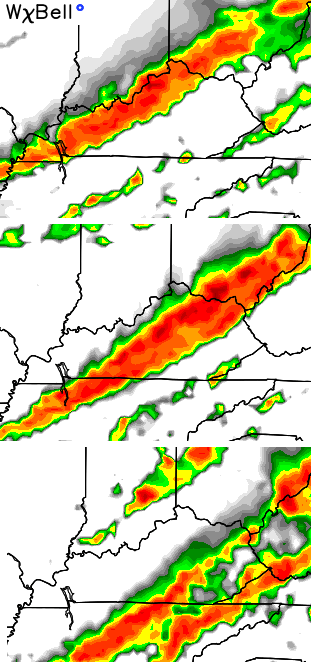 The higher resolution NAM shows something very similar…

Here are the threats in order of potential…
1. Damaging winds
2. Heavy rains that cause local flash flooding
3. Large hail
4. Small tornado risk
These storms should also contain a lot of lightning (LOL) as they roll through here.
I’ll hook you up with all the severe weather tracking tools you need with the overnight update. Here are some to track today’s steam and scattered storms going up…


Enjoy the afternoon and take care.

Looks like a good opportunity to fire up Periscope at the Station for Continuous coverage
Perhaps a sign of things to come. A new Severe Thunderstorm Watch now out for central and northern parts of Illinois and Indiana. As CB pointed out, severe straight-line winds will be the risk with the highest chances.
Don’t need the severe storms, but we do need something to wash away these allergies. Today is the worst one I’ve had in years.
We still need rain in some areas in KY! GFS has failed most of us with the ridiculous amounts of rain forecasted from mid May to today’s current date! I only picked up 1.5 inches for the entire month of May plus .55 inches for the first week of June. However, I like how NAM handles short-term severe weather systems and feel more confident that this data will better represent what will happen compared to the crazy GFS runs over the past few weeks:)