Good Saturday, everyone. The past few days of weather have me thinking fall and football, and I’m sure many of you may be thinking the same way. If this didn’t do the trick, just wait until next week! We have a big blast of late September air on the way to our region.
Before we get to that blast of September, we have a warmer weekend taking shape. Highs will hit the low and middle 80s today for many areas. Some upper 80s will be possible in the west.
Sunday will see more humidity and temps increasing just a bit. Isolated showers and storms will develop as the day wears on.
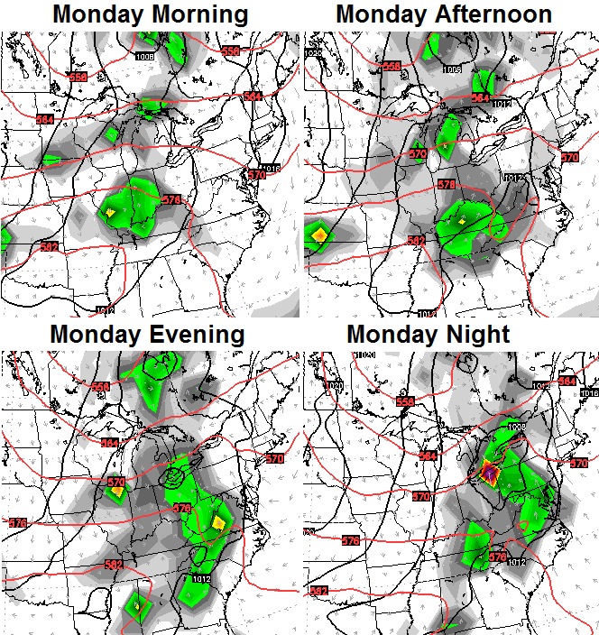
A strong cold front then sweeps into the region on Monday with widespread showers and thunderstorms…
Check out the blast of awesome air coming in behind that system…

Temperatures from Tuesday through Friday may struggle to get out of the 70s for many areas with lows deep into the 50s. Given the cool first week of August, this is very likely to make this a colder than normal month overall.
Tonight’s update will have a lot of winter talk. See ya then!
Enjoy your day and take care.

Finally through the worst of it! 🙂
Dang, you cool weather lovers, I guess it’s time to shut the pool down for the summer, way too early I might add. We’ve got all fall for cool weather. Some of you would just take 68-70 degrees year round I guess. Hot summers make you appreciate the cooler falls. I’m over this ridiculously rainy summer. Don’t care if I see another green lawn this year.
Dont shut ‘er down yet lol – some other forecasts for SE Ky. anyway show weds and thurs in the upper 70s dancing right back to mid 80s by Friday. Remain calm and put away the snow boots LOL
Yes, please. I’ll gladly mow the nice green lawn until November. Since winters last till April now, let’s keep the heat till Thanksgiving.
I think if will be a warmer summer….I hope not, but doesn’t el nino usually cause above avg temps?